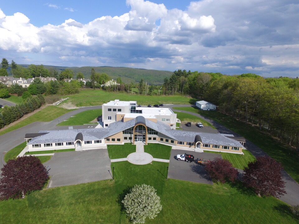
Property Record
150 Pittsfield Rd, Lenox, MA 01240


Current Lease Availabilities
NEARBY LISTINGS FOR SALE OR LEASE
Property Detail
150 Pittsfield Rd
Pittsfield, MA
Berkshire
LENO-000022-000034
Massachusetts
Commercialnec
5.97 AC
2020
Massachusetts North/West Area
2024
Other Market Areas
913100
DEMOGRAPHICS near 150 Pittsfield Rd
1 Mile
3 Mile
5 Mile
2024 Total Population
1,194
6,416
29,584
2029 Population
1,220
6,504
29,335
Pop Growth 2024-2029
+ 2.18%
+ 1.37%
(0.84%)
Average Age
51
52
47
2024 Total Households
529
3,047
13,507
HH Growth 2024-2029
+ 2.46%
+ 1.44%
(0.84%)
Median Household Inc
$86,111
$80,826
$67,129
Avg Household Size
2.00
2.00
2.10
2024 Avg HH Vehicles
2.00
2.00
2.00
Median Home Value
$387,878
$370,811
$277,283
Median Year Built
1973
1967
1951
Nearby Places
- Restaurants
- Banks
- Shops
- Fitness
- Groceries
PUBLIC TRANSPORTATION
COMMUTER RAIL
Pittsfield Amtrak Station (Empire Service - Amtrak, Lake Shore Limited - Amtrak)
DRIVE
WALK
Distance
Pittsfield Amtrak Station (Empire Service - Amtrak, Lake Shore Limited - Amtrak)
10 min
5.0 mi
Freight Ports
Albany, NY Port
DRIVE
WALK
Distance
Albany, NY Port
66 min
50.9 mi
Nearby Properties
Address
Land Use
TOTAL SIZE
Lot Size
Zoning
Address
Land Use
TOTAL SIZE
Lot Size
Zoning
91.73 AC
R-1A
Address
Land Use
TOTAL SIZE
Lot Size
Zoning
60.39 AC
R-1A
Address
Land Use
TOTAL SIZE
Lot Size
Zoning
34.68 AC
C-1A
Address
Land Use
TOTAL SIZE
Lot Size
Zoning
29.60 AC
R-1A
Address
Land Use
TOTAL SIZE
Lot Size
Zoning
32.73 AC
C-3A
Address
Land Use
TOTAL SIZE
Lot Size
Zoning
59,169 SF
10.10 AC
R-1A
Address
Land Use
TOTAL SIZE
Lot Size
Zoning
286 AC
LDI
Address
Land Use
TOTAL SIZE
Lot Size
Zoning
19,286 SF
32.70 AC
R-1A
Address
Land Use
TOTAL SIZE
Lot Size
Zoning
57,676 SF
6.68 AC
C-3A
Address
Land Use
TOTAL SIZE
Lot Size
Zoning
17.26 AC
BG
Address
Land Use
TOTAL SIZE
Lot Size
Zoning
41 AC
R4
Address
Land Use
TOTAL SIZE
Lot Size
Zoning
12.16 AC
R-1A
Address
Land Use
TOTAL SIZE
Lot Size
Zoning
1.90 AC
COMMER
Address
Land Use
TOTAL SIZE
Lot Size
Zoning
469 AC
R-3A
Address
Land Use
TOTAL SIZE
Lot Size
Zoning
79,785 SF
2.29 AC
BG
Address
Land Use
TOTAL SIZE
Lot Size
Zoning
142,802 SF
13.74 AC
IL
Address
Land Use
TOTAL SIZE
Lot Size
Zoning
44,912 SF
6.55 AC
C-1A
Address
Land Use
TOTAL SIZE
Lot Size
Zoning
12.76 AC
R-1A
Address
Land Use
TOTAL SIZE
Lot Size
Zoning
12.96 AC
BG
Address
Land Use
TOTAL SIZE
Lot Size
Zoning
27,569 SF
10.40 AC
C-3A
Address
Land Use
TOTAL SIZE
Lot Size
Zoning
38,500 SF
4.80 AC
R-15
Address
Land Use
TOTAL SIZE
Lot Size
Zoning
340.40 AC
R-3A
Address
Land Use
TOTAL SIZE
Lot Size
Zoning
7.79 AC
R-30
Address
Land Use
TOTAL SIZE
Lot Size
Zoning
122.70 AC
R43
Address
Land Use
TOTAL SIZE
Lot Size
Zoning
7,136 SF
31.10 AC
C-3A
Address
Land Use
TOTAL SIZE
Lot Size
Zoning
312.94 AC
R-1A
Address
Land Use
TOTAL SIZE
Lot Size
Zoning
19.24 AC
C-1A
Address
Land Use
TOTAL SIZE
Lot Size
Zoning
112,374 SF
19.30 AC
INDUST
Address
Land Use
TOTAL SIZE
Lot Size
Zoning
8,236 SF
43 AC
RA-C
Address
Land Use
TOTAL SIZE
Lot Size
Zoning
4,749 SF
13.70 AC
R4
The World's #1 Commercial Real Estate Marketplace
Connect with us
© 2025 CoStar Group
The information above has been obtained from sources believed reliable. While we do not doubt its accuracy we have not verified it and make no guarantee, warranty or representation about it. It is your responsibility to independently confirm its accuracy and completeness. Any projections, opinions, assumptions, or estimates used are for example only and do not represent the current or future performance of the property. The value of this transaction to you depends on tax and other factors which should be evaluated by your tax, financial, and legal advisors. You and your advisors should conduct a careful, independent investigation of the property to determine to your satisfaction the suitability of the property for your needs.