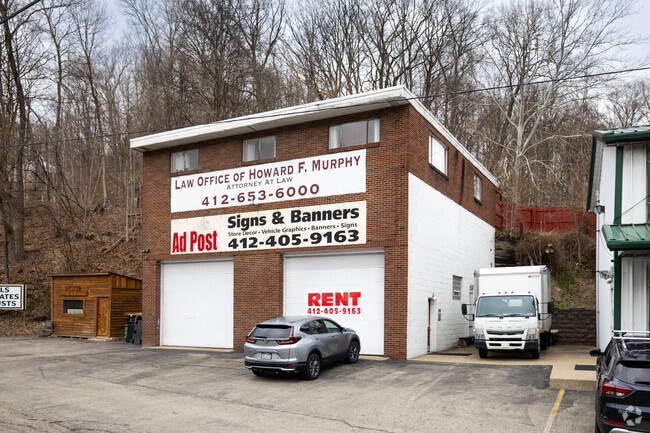
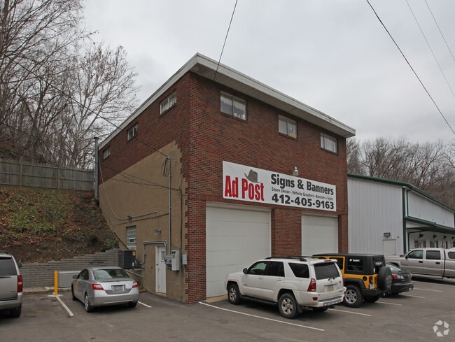
Property Record
1501 Route 51, Clairton, PA 15025

NEARBY LISTINGS FOR SALE OR LEASE
-
-
-
-
-
-
-
800 Fifth Street, West Elizabeth, PA 15088
Elizabeth, PA 15037
$8.00 - $12.00 SF/YR
775 - 3,500 SF
Retail
-
View all Clairton listings for lease on LoopNet.com
Property Detail
1501 Route 51
Pittsburgh, PA
LOT 223.87XAVG84.5X192.34 RR LEWIS RUN RD 1 STY ALUM HSE 501 1 CAR FRA GAR
0766-L-00200-0000-00
Allegheny
Retailwithmorethanonenonretailuse
Pennsylvania
X
200
42003C0491H
0.80 AC
2024
South Pittsburgh/Rte 51
2025
Pittsburgh
491200
DEMOGRAPHICS near 1501 Route 51
1 Mile
3 Mile
5 Mile
2024 Total Population
1,905
33,967
95,308
2029 Population
1,874
33,528
94,072
Pop Growth 2024-2029
(1.63%)
(1.29%)
(1.30%)
Average Age
44
43
43
2024 Total Households
712
14,110
40,413
HH Growth 2024-2029
(1.69%)
(1.25%)
(1.32%)
Median Household Inc
$118,749
$70,429
$66,086
Avg Household Size
2.50
2.30
2.30
2024 Avg HH Vehicles
2.00
2.00
2.00
Median Home Value
$332,368
$194,838
$161,595
Median Year Built
1983
1957
1957
Nearby Places
Map Layers
Map Styles
 Street
 Aerial
- Restaurants
- Banks
- Shops
- Fitness
- Groceries
PUBLIC TRANSPORTATION
AIRPORT
Pittsburgh International
DRIVE
WALK
Distance
Pittsburgh International
49 min
27.2 mi
Arnold Palmer Regional
DRIVE
WALK
Distance
Arnold Palmer Regional
63 min
38.6 mi
SALE & LEASE HISTORY
LISTING DATE
SALE/LEASE

Dec 12, 2018
For Lease
Nearby Properties
Address
Land Use
TOTAL SIZE
Lot Size
Zoning
Address
Land Use
TOTAL SIZE
Lot Size
Zoning
183.54 AC
Address
Land Use
TOTAL SIZE
Lot Size
Zoning
237.75 AC
Address
Land Use
TOTAL SIZE
Lot Size
Zoning
160.53 AC
Address
Land Use
TOTAL SIZE
Lot Size
Zoning
25.50 AC
Address
Land Use
TOTAL SIZE
Lot Size
Zoning
33.09 AC
Address
Land Use
TOTAL SIZE
Lot Size
Zoning
14.61 AC
Address
Land Use
TOTAL SIZE
Lot Size
Zoning
10.21 AC
Address
Land Use
TOTAL SIZE
Lot Size
Zoning
460.86 AC
Address
Land Use
TOTAL SIZE
Lot Size
Zoning
2.98 AC
Address
Land Use
TOTAL SIZE
Lot Size
Zoning
72.10 AC
Address
Land Use
TOTAL SIZE
Lot Size
Zoning
74.33 AC
Address
Land Use
TOTAL SIZE
Lot Size
Zoning
37.90 AC
Address
Land Use
TOTAL SIZE
Lot Size
Zoning
36.27 AC
Address
Land Use
TOTAL SIZE
Lot Size
Zoning
Address
Land Use
TOTAL SIZE
Lot Size
Zoning
35.72 AC
Address
Land Use
TOTAL SIZE
Lot Size
Zoning
2.77 AC
Address
Land Use
TOTAL SIZE
Lot Size
Zoning
11.25 AC
Address
Land Use
TOTAL SIZE
Lot Size
Zoning
242.22 AC
Address
Land Use
TOTAL SIZE
Lot Size
Zoning
10.79 AC
Address
Land Use
TOTAL SIZE
Lot Size
Zoning
Address
Land Use
TOTAL SIZE
Lot Size
Zoning
Address
Land Use
TOTAL SIZE
Lot Size
Zoning
Address
Land Use
TOTAL SIZE
Lot Size
Zoning
4.84 AC
Address
Land Use
TOTAL SIZE
Lot Size
Zoning
14.49 AC
Address
Land Use
TOTAL SIZE
Lot Size
Zoning
11.81 AC
Address
Land Use
TOTAL SIZE
Lot Size
Zoning
28.05 AC
Address
Land Use
TOTAL SIZE
Lot Size
Zoning
Address
Land Use
TOTAL SIZE
Lot Size
Zoning
Address
Land Use
TOTAL SIZE
Lot Size
Zoning
Address
Land Use
TOTAL SIZE
Lot Size
Zoning
The World's #1 Commercial Real Estate Marketplace
Connect with us
© 2025 CoStar Group
The information above has been obtained from sources believed reliable. While we do not doubt its accuracy we have not verified it and make no guarantee, warranty or representation about it. It is your responsibility to independently confirm its accuracy and completeness. Any projections, opinions, assumptions, or estimates used are for example only and do not represent the current or future performance of the property. The value of this transaction to you depends on tax and other factors which should be evaluated by your tax, financial, and legal advisors. You and your advisors should conduct a careful, independent investigation of the property to determine to your satisfaction the suitability of the property for your needs.