Property Record
15090 Highway 6, Rosharon, TX 77583
Current Lease Availabilities
NEARBY LISTINGS FOR SALE OR LEASE
-
-
View all Rosharon listings for lease on LoopNet.com
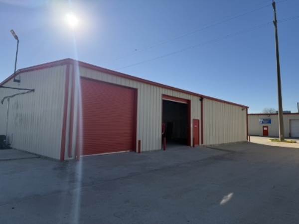
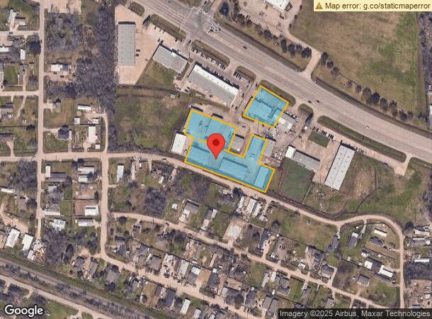
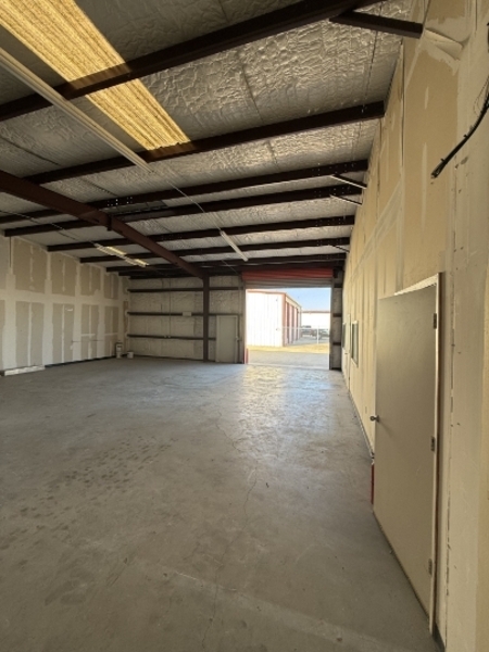
Property Detail
15090 Highway 6
Houston-The Woodlands-Sugar Land, TX
Braebend Estates (A0280 H T & B R R)
2140-0255-000
BRAEBEND ESTATES (A0280 H T & B R R) BLK 14 LOT 11-12 - BLK 15 LOT 4-5-6-8-18TO22
Commercialnec
Brazoria
X
Texas
48039C0105K
11
2023
2.46 AC
2023
South Hwy 35
6619001007
Houston
35,930 SF
DEMOGRAPHICS near 15090 Highway 6
1 Mile
3 Mile
5 Mile
2024 Total Population
6,015
45,980
135,592
2029 Population
6,759
54,710
158,399
Pop Growth 2024-2029
+ 12.37%
+ 18.99%
+ 16.82%
Average Age
35
34
35
2024 Total Households
1,814
13,952
42,230
HH Growth 2024-2029
+ 12.46%
+ 19.41%
+ 17.11%
Median Household Inc
$117,897
$79,046
$103,278
Avg Household Size
3.20
3.20
3.20
2024 Avg HH Vehicles
2.00
2.00
2.00
Median Home Value
$273,384
$238,559
$304,740
Median Year Built
2009
2010
2010
Nearby Places
- Restaurants
- Banks
- Shops
- Fitness
- Groceries
PUBLIC TRANSPORTATION
AIRPORT
William P Hobby
DRIVE
WALK
Distance
William P Hobby
35 min
20.6 mi
Freight Ports
Port of Houston
DRIVE
WALK
Distance
Port of Houston
40 min
27.4 mi
Nearby Properties
Address
Land Use
TOTAL SIZE
Lot Size
Zoning
Address
Land Use
TOTAL SIZE
Lot Size
Zoning
70,000 SF
64.91 AC
Address
Land Use
TOTAL SIZE
Lot Size
Zoning
15.28 AC
0015
Address
Land Use
TOTAL SIZE
Lot Size
Zoning
105,790 SF
12.82 AC
X
Address
Land Use
TOTAL SIZE
Lot Size
Zoning
13.85 AC
Address
Land Use
TOTAL SIZE
Lot Size
Zoning
82,400 SF
10.85 AC
I
Address
Land Use
TOTAL SIZE
Lot Size
Zoning
2,000 SF
24.84 AC
Address
Land Use
TOTAL SIZE
Lot Size
Zoning
28,633 SF
9.36 AC
Address
Land Use
TOTAL SIZE
Lot Size
Zoning
44,735 SF
120.87 AC
0010
Address
Land Use
TOTAL SIZE
Lot Size
Zoning
214,827 SF
15.70 AC
0033
Address
Land Use
TOTAL SIZE
Lot Size
Zoning
94,094 SF
5.86 AC
Address
Land Use
TOTAL SIZE
Lot Size
Zoning
127,500 SF
7.60 AC
Address
Land Use
TOTAL SIZE
Lot Size
Zoning
98,957 SF
10.70 AC
Address
Land Use
TOTAL SIZE
Lot Size
Zoning
103,673 SF
20.13 AC
0007
Address
Land Use
TOTAL SIZE
Lot Size
Zoning
75,548 SF
12.30 AC
Address
Land Use
TOTAL SIZE
Lot Size
Zoning
37,000 SF
6.06 AC
0218
Address
Land Use
TOTAL SIZE
Lot Size
Zoning
17,481 SF
12.54 AC
Address
Land Use
TOTAL SIZE
Lot Size
Zoning
9,940 SF
2.08 AC
Address
Land Use
TOTAL SIZE
Lot Size
Zoning
29,625 SF
2.01 AC
Address
Land Use
TOTAL SIZE
Lot Size
Zoning
14,575 SF
2.13 AC
Address
Land Use
TOTAL SIZE
Lot Size
Zoning
2.92 AC
Address
Land Use
TOTAL SIZE
Lot Size
Zoning
14,543 SF
2.22 AC
Address
Land Use
TOTAL SIZE
Lot Size
Zoning
13,328 SF
5.33 AC
Address
Land Use
TOTAL SIZE
Lot Size
Zoning
9,298 SF
3.22 AC
Address
Land Use
TOTAL SIZE
Lot Size
Zoning
6,538 SF
9.85 AC
0039
Address
Land Use
TOTAL SIZE
Lot Size
Zoning
6,538 SF
4.42 AC
Address
Land Use
TOTAL SIZE
Lot Size
Zoning
25,613 SF
10.11 AC
0034
Address
Land Use
TOTAL SIZE
Lot Size
Zoning
67,064 SF
5 AC
0034
Address
Land Use
TOTAL SIZE
Lot Size
Zoning
6,710 SF
1.93 AC
Address
Land Use
TOTAL SIZE
Lot Size
Zoning
832 SF
0.96 AC
S
The World's #1 Commercial Real Estate Marketplace
Connect with us
© 2025 CoStar Group
The information above has been obtained from sources believed reliable. While we do not doubt its accuracy we have not verified it and make no guarantee, warranty or representation about it. It is your responsibility to independently confirm its accuracy and completeness. Any projections, opinions, assumptions, or estimates used are for example only and do not represent the current or future performance of the property. The value of this transaction to you depends on tax and other factors which should be evaluated by your tax, financial, and legal advisors. You and your advisors should conduct a careful, independent investigation of the property to determine to your satisfaction the suitability of the property for your needs.