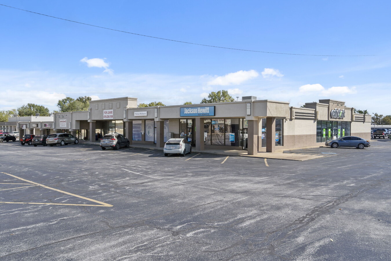
Property Record
151 E Highway 412 Hwy E, Siloam Springs, AR 72761

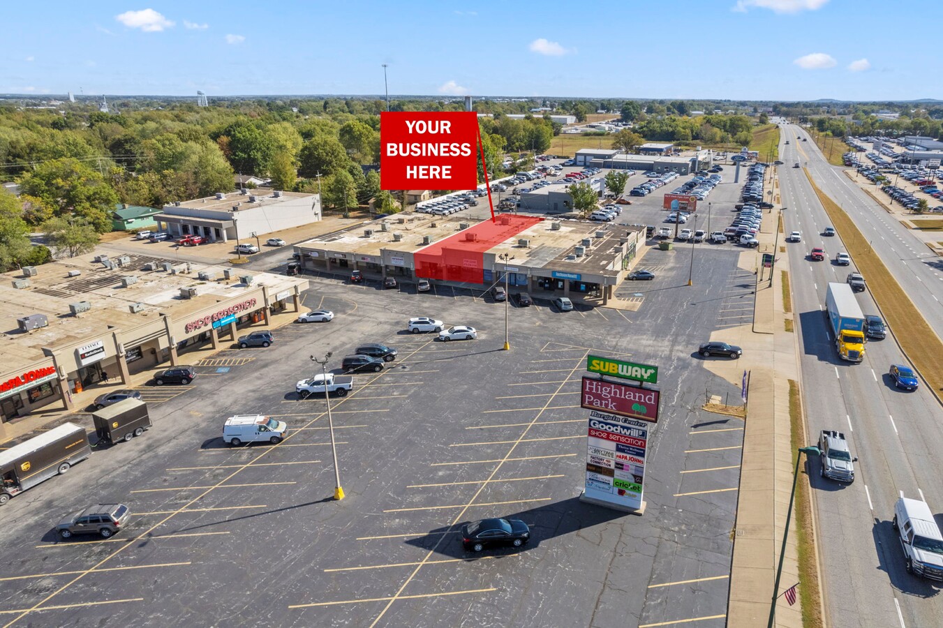
Current Lease Availabilities
NEARBY LISTINGS FOR SALE OR LEASE
Property Detail
151 E Highway 412 Hwy E
03-00219-000
Siloam Springs
Regionalshoppingcenterormallwithanchorstore
PT S/2 NW NW NE, N PT SW NW NE BEG NW/C L 1 CARNEYS CORNER (E30 S10 NW/C NE/4) THENCE N88*E421 S0*E100 S88*W125 S150 N88*E115 CURVE LEFT 124.22 S89*E189.10 S309.70 S89*W488.12 N01*W153.90 S87*W140 N01*W498.79 TO POB
X
Benton
40041C0600E
Arkansas
2024
4.19 AC
2024
Outlying Benton County
021101
Fayetteville/Springdale/Rogers
22,320 SF
Fayetteville-Springdale-Rogers, AR-MO
DEMOGRAPHICS near 151 E Highway 412 Hwy E
1 Mile
3 Mile
5 Mile
2024 Total Population
6,384
21,511
26,470
2029 Population
7,479
25,241
30,899
Pop Growth 2024-2029
+ 17.15%
+ 17.34%
+ 16.73%
Average Age
36
36
37
2024 Total Households
2,267
7,413
9,175
HH Growth 2024-2029
+ 17.20%
+ 17.37%
+ 16.73%
Median Household Inc
$52,566
$60,301
$61,367
Avg Household Size
2.70
2.70
2.70
2024 Avg HH Vehicles
2.00
2.00
2.00
Median Home Value
$175,643
$188,754
$194,023
Median Year Built
1984
1992
1992
Nearby Places
- Restaurants
- Banks
- Shops
- Fitness
- Groceries
PUBLIC TRANSPORTATION
AIRPORT
Northwest Arkansas Regional
DRIVE
WALK
Distance
Northwest Arkansas Regional
32 min
22.5 mi
Freight Ports
Port of Shreveport
DRIVE
WALK
Distance
Port of Shreveport
1 min
268.8 mi
Nearby Properties
Address
Land Use
TOTAL SIZE
Lot Size
Zoning
Address
Land Use
TOTAL SIZE
Lot Size
Zoning
85,903 SF
10 AC
Address
Land Use
TOTAL SIZE
Lot Size
Zoning
91,795 SF
Address
Land Use
TOTAL SIZE
Lot Size
Zoning
140,452 SF
9.28 AC
Address
Land Use
TOTAL SIZE
Lot Size
Zoning
183,822 SF
23.62 AC
Address
Land Use
TOTAL SIZE
Lot Size
Zoning
190,712 SF
15.73 AC
Address
Land Use
TOTAL SIZE
Lot Size
Zoning
119,258 SF
16.25 AC
Address
Land Use
TOTAL SIZE
Lot Size
Zoning
398,700 SF
61.85 AC
Address
Land Use
TOTAL SIZE
Lot Size
Zoning
30,542 SF
66.48 AC
Address
Land Use
TOTAL SIZE
Lot Size
Zoning
190,790 SF
25.17 AC
Address
Land Use
TOTAL SIZE
Lot Size
Zoning
422,489 SF
57.90 AC
Address
Land Use
TOTAL SIZE
Lot Size
Zoning
53,071 SF
2.07 AC
Address
Land Use
TOTAL SIZE
Lot Size
Zoning
110,904 SF
15.22 AC
Address
Land Use
TOTAL SIZE
Lot Size
Zoning
54,187 SF
18.61 AC
Address
Land Use
TOTAL SIZE
Lot Size
Zoning
264,685 SF
14.13 AC
Address
Land Use
TOTAL SIZE
Lot Size
Zoning
23,133 SF
3 AC
Address
Land Use
TOTAL SIZE
Lot Size
Zoning
98,492 SF
6.33 AC
Address
Land Use
TOTAL SIZE
Lot Size
Zoning
20,475 SF
19.62 AC
Address
Land Use
TOTAL SIZE
Lot Size
Zoning
21,974 SF
3.87 AC
Address
Land Use
TOTAL SIZE
Lot Size
Zoning
92,300 SF
6.35 AC
Address
Land Use
TOTAL SIZE
Lot Size
Zoning
144,166 SF
12.49 AC
Address
Land Use
TOTAL SIZE
Lot Size
Zoning
87,684 SF
5.43 AC
Address
Land Use
TOTAL SIZE
Lot Size
Zoning
36,185 SF
0.78 AC
Address
Land Use
TOTAL SIZE
Lot Size
Zoning
64,710 SF
2.32 AC
Address
Land Use
TOTAL SIZE
Lot Size
Zoning
57,503 SF
7.08 AC
Address
Land Use
TOTAL SIZE
Lot Size
Zoning
41,748 SF
5.44 AC
Address
Land Use
TOTAL SIZE
Lot Size
Zoning
6,547 SF
5.48 AC
Address
Land Use
TOTAL SIZE
Lot Size
Zoning
20,714 SF
0.57 AC
Address
Land Use
TOTAL SIZE
Lot Size
Zoning
40,709 SF
4.24 AC
Address
Land Use
TOTAL SIZE
Lot Size
Zoning
61,560 SF
9.33 AC
Address
Land Use
TOTAL SIZE
Lot Size
Zoning
4,888 SF
5.30 AC
The World's #1 Commercial Real Estate Marketplace
Connect with us
© 2025 CoStar Group
The information above has been obtained from sources believed reliable. While we do not doubt its accuracy we have not verified it and make no guarantee, warranty or representation about it. It is your responsibility to independently confirm its accuracy and completeness. Any projections, opinions, assumptions, or estimates used are for example only and do not represent the current or future performance of the property. The value of this transaction to you depends on tax and other factors which should be evaluated by your tax, financial, and legal advisors. You and your advisors should conduct a careful, independent investigation of the property to determine to your satisfaction the suitability of the property for your needs.