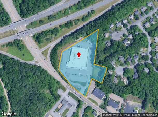
Property Record
151 Main St, Shrewsbury, MA 01545
NEARBY LISTINGS FOR SALE OR LEASE
-
-
-
-
No Photo
-
-
-
-
View all Shrewsbury listings for sale on LoopNet.com
Property Detail
151 Main St
Hospitalprivate
Worcester
X
Massachusetts
25027C0620E
4.93 AC
2025
Worcester Metro
2025
Boston
739500
Worcester, MA-CT
40,733 SF
SHRE-000019-000000-144000
DEMOGRAPHICS near 151 Main St
1 Mile
3 Mile
5 Mile
2024 Total Population
5,244
82,140
220,270
2029 Population
5,245
81,556
218,257
Pop Growth 2024-2029
+ 0.02%
(0.71%)
(0.91%)
Average Age
41
40
39
2024 Total Households
2,087
33,002
85,730
HH Growth 2024-2029
+ 0.05%
(0.75%)
(0.90%)
Median Household Inc
$102,026
$75,606
$72,890
Avg Household Size
2.40
2.40
2.40
2024 Avg HH Vehicles
2.00
2.00
2.00
Median Home Value
$427,032
$374,592
$372,636
Median Year Built
1979
1958
1957
Nearby Places
- Restaurants
- Banks
- Shops
- Fitness
- Groceries
PUBLIC TRANSPORTATION
COMMUTER RAIL
Worcester Union Station (Lake Shore Limited - Amtrak)
DRIVE
WALK
Distance
Worcester Union Station (Lake Shore Limited - Amtrak)
8 min
5.1 mi
Worcester (Framingham/Worcester Line - Massachusetts Bay Transportation Authority Commuter Rail (Purple Line))
DRIVE
WALK
Distance
Worcester (Framingham/Worcester Line - Massachusetts Bay Transportation Authority Commuter Rail (Purple Line))
8 min
5.2 mi
AIRPORT
Worcester Regional
DRIVE
WALK
Distance
Worcester Regional
18 min
9.6 mi
Freight Ports
Port of Boston
DRIVE
WALK
Distance
Port of Boston
61 min
41.2 mi
Nearby Properties
Address
Land Use
TOTAL SIZE
Lot Size
Zoning
Address
Land Use
TOTAL SIZE
Lot Size
Zoning
457,170 SF
29.92 AC
ML-.5
Address
Land Use
TOTAL SIZE
Lot Size
Zoning
20.01 AC
BG-2
Address
Land Use
TOTAL SIZE
Lot Size
Zoning
26,152 SF
7.97 AC
COM BU
Address
Land Use
TOTAL SIZE
Lot Size
Zoning
155,421 SF
65.04 AC
RL-7
Address
Land Use
TOTAL SIZE
Lot Size
Zoning
51.05 AC
BO-1
Address
Land Use
TOTAL SIZE
Lot Size
Zoning
524,527 SF
45.16 AC
BL-1
Address
Land Use
TOTAL SIZE
Lot Size
Zoning
362,937 SF
91.58 AC
Address
Land Use
TOTAL SIZE
Lot Size
Zoning
Address
Land Use
TOTAL SIZE
Lot Size
Zoning
43.07 AC
COM BU
Address
Land Use
TOTAL SIZE
Lot Size
Zoning
295,000 SF
194.17 AC
RUR B
Address
Land Use
TOTAL SIZE
Lot Size
Zoning
16.01 AC
COM BU
Address
Land Use
TOTAL SIZE
Lot Size
Zoning
50.11 AC
RS-7
Address
Land Use
TOTAL SIZE
Lot Size
Zoning
272,824 SF
14.95 AC
BL-1
Address
Land Use
TOTAL SIZE
Lot Size
Zoning
30.93 AC
RG-5
Address
Land Use
TOTAL SIZE
Lot Size
Zoning
Address
Land Use
TOTAL SIZE
Lot Size
Zoning
176,316 SF
19.57 AC
RL-7
Address
Land Use
TOTAL SIZE
Lot Size
Zoning
70,514 SF
31.64 AC
RL-7
Address
Land Use
TOTAL SIZE
Lot Size
Zoning
15.42 AC
RG-5
Address
Land Use
TOTAL SIZE
Lot Size
Zoning
194,264 SF
4.32 AC
BL-1
Address
Land Use
TOTAL SIZE
Lot Size
Zoning
142,438 SF
14.26 AC
RES B-
Address
Land Use
TOTAL SIZE
Lot Size
Zoning
174,807 SF
32.43 AC
RES B-
Address
Land Use
TOTAL SIZE
Lot Size
Zoning
203,184 SF
10.01 AC
MF-1
Address
Land Use
TOTAL SIZE
Lot Size
Zoning
491,632 SF
RL-7
Address
Land Use
TOTAL SIZE
Lot Size
Zoning
15.36 AC
RS-7
Address
Land Use
TOTAL SIZE
Lot Size
Zoning
9.70 AC
COM BU
Address
Land Use
TOTAL SIZE
Lot Size
Zoning
154,200 SF
4.87 AC
BL-1
Address
Land Use
TOTAL SIZE
Lot Size
Zoning
10 AC
MF-1 9
Address
Land Use
TOTAL SIZE
Lot Size
Zoning
13.95 AC
RG-5
Address
Land Use
TOTAL SIZE
Lot Size
Zoning
217,500 SF
51.71 AC
LIM CO
Address
Land Use
TOTAL SIZE
Lot Size
Zoning
121,780 SF
1.39 AC
BG-6
The World's #1 Commercial Real Estate Marketplace
Connect with us
© 2025 CoStar Group
The information above has been obtained from sources believed reliable. While we do not doubt its accuracy we have not verified it and make no guarantee, warranty or representation about it. It is your responsibility to independently confirm its accuracy and completeness. Any projections, opinions, assumptions, or estimates used are for example only and do not represent the current or future performance of the property. The value of this transaction to you depends on tax and other factors which should be evaluated by your tax, financial, and legal advisors. You and your advisors should conduct a careful, independent investigation of the property to determine to your satisfaction the suitability of the property for your needs.