Property Record
151 Montgomery Xing, Biscoe, NC 27209

NEARBY LISTINGS FOR SALE OR LEASE
Property Detail
151 Montgomery Xing
7568-10-26-6150
Alta Acsm Land Title Survey And Minor Su
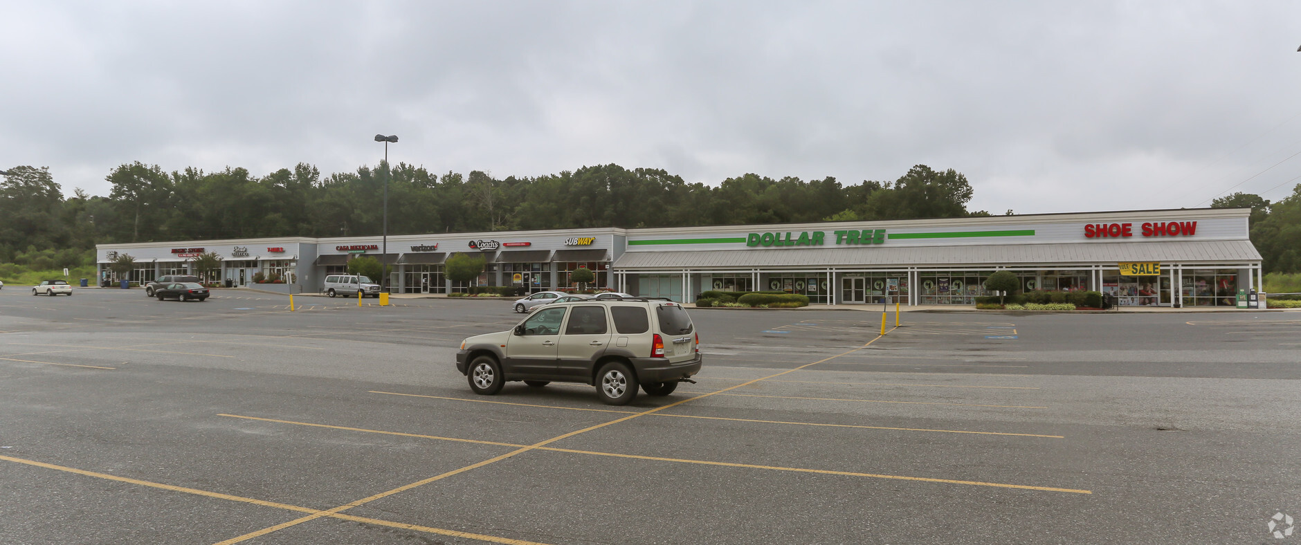
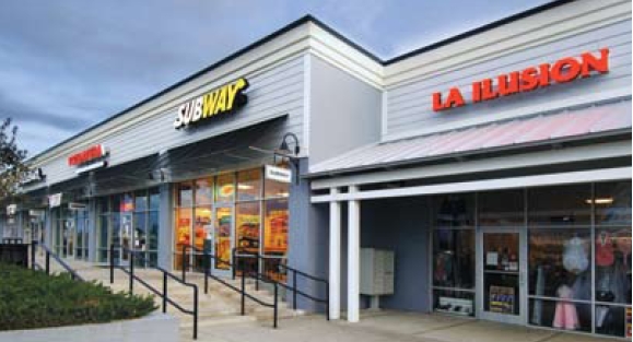
Regionalshoppingcenterormallwithanchorstore
MONTGOMERY CROSSING LODESTAR - TRACT 2 LODESTAR #2
AE
Montgomery
3710756800J
North Carolina
2024
3.61 AC
2024
North Carolina Southeast Area
960102
Other Market Areas
25,440 SF
DEMOGRAPHICS near 151 Montgomery Xing
1 Mile
3 Mile
5 Mile
2024 Total Population
965
3,207
5,774
2029 Population
928
3,084
5,599
Pop Growth 2024-2029
(3.83%)
(3.84%)
(3.03%)
Average Age
37
38
39
2024 Total Households
320
1,113
2,043
HH Growth 2024-2029
(4.38%)
(4.31%)
(3.43%)
Median Household Inc
$38,499
$40,085
$41,579
Avg Household Size
2.70
2.70
2.60
2024 Avg HH Vehicles
2.00
2.00
2.00
Median Home Value
$162,272
$146,385
$141,655
Median Year Built
1973
1972
1973
Nearby Places
- Restaurants
- Banks
- Shops
- Fitness
- Groceries
SALE & LEASE HISTORY
LISTING DATE
SALE/LEASE

Sep 25, 2016
For Lease
Jan 14, 2020
For Lease
Nearby Properties
Address
Land Use
TOTAL SIZE
Lot Size
Zoning
Address
Land Use
TOTAL SIZE
Lot Size
Zoning
97,930 SF
44.22 AC
SCHOOL
Address
Land Use
TOTAL SIZE
Lot Size
Zoning
73,811 SF
53.83 AC
SCHOOL
Address
Land Use
TOTAL SIZE
Lot Size
Zoning
107,231 SF
13.41 AC
DISCOUNT S
Address
Land Use
TOTAL SIZE
Lot Size
Zoning
30,096 SF
34.29 AC
Address
Land Use
TOTAL SIZE
Lot Size
Zoning
82,280 SF
113.49 AC
SCHOOL
Address
Land Use
TOTAL SIZE
Lot Size
Zoning
42,315 SF
7.83 AC
SCHOOL
Address
Land Use
TOTAL SIZE
Lot Size
Zoning
47,914 SF
6.94 AC
SKILLED NU
Address
Land Use
TOTAL SIZE
Lot Size
Zoning
77,511 SF
197.08 AC
INDUSTRIAL
Address
Land Use
TOTAL SIZE
Lot Size
Zoning
63,123 SF
10.46 AC
INDUSTRIAL
Address
Land Use
TOTAL SIZE
Lot Size
Zoning
13,328 SF
3.93 AC
Address
Land Use
TOTAL SIZE
Lot Size
Zoning
44,144 SF
8.28 AC
Address
Land Use
TOTAL SIZE
Lot Size
Zoning
13,238 SF
4.79 AC
Address
Land Use
TOTAL SIZE
Lot Size
Zoning
358,859 SF
21.89 AC
INDUSTRIAL
Address
Land Use
TOTAL SIZE
Lot Size
Zoning
20,540 SF
14.61 AC
INDUSTRIAL
Address
Land Use
TOTAL SIZE
Lot Size
Zoning
14,391 SF
2.42 AC
SKILLED NU
Address
Land Use
TOTAL SIZE
Lot Size
Zoning
17,344 SF
1.50 AC
HOTEL/MOTE
Address
Land Use
TOTAL SIZE
Lot Size
Zoning
3,513 SF
0.82 AC
FAST FOOD
Address
Land Use
TOTAL SIZE
Lot Size
Zoning
13,020 SF
0.57 AC
CHURCH
Address
Land Use
TOTAL SIZE
Lot Size
Zoning
3,888 SF
0.85 AC
FAST FOOD
Address
Land Use
TOTAL SIZE
Lot Size
Zoning
10,080 SF
10.06 AC
APARTMENTS
Address
Land Use
TOTAL SIZE
Lot Size
Zoning
18,485 SF
18.83 AC
Address
Land Use
TOTAL SIZE
Lot Size
Zoning
9,291 SF
7.01 AC
CHURCH
Address
Land Use
TOTAL SIZE
Lot Size
Zoning
4,925 SF
0.90 AC
Address
Land Use
TOTAL SIZE
Lot Size
Zoning
111,700 SF
6.25 AC
INDUSTRIAL
Address
Land Use
TOTAL SIZE
Lot Size
Zoning
8,530 SF
2.53 AC
CHURCH
Address
Land Use
TOTAL SIZE
Lot Size
Zoning
7,425 SF
2.85 AC
MEDICAL OF
Address
Land Use
TOTAL SIZE
Lot Size
Zoning
7,360 SF
1 AC
Address
Land Use
TOTAL SIZE
Lot Size
Zoning
3,727 SF
0.97 AC
FAST FOOD
Address
Land Use
TOTAL SIZE
Lot Size
Zoning
7,300 SF
0.81 AC
The World's #1 Commercial Real Estate Marketplace
Connect with us
© 2025 CoStar Group
The information above has been obtained from sources believed reliable. While we do not doubt its accuracy we have not verified it and make no guarantee, warranty or representation about it. It is your responsibility to independently confirm its accuracy and completeness. Any projections, opinions, assumptions, or estimates used are for example only and do not represent the current or future performance of the property. The value of this transaction to you depends on tax and other factors which should be evaluated by your tax, financial, and legal advisors. You and your advisors should conduct a careful, independent investigation of the property to determine to your satisfaction the suitability of the property for your needs.