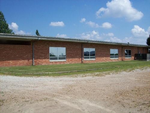
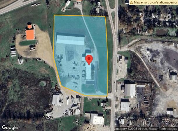
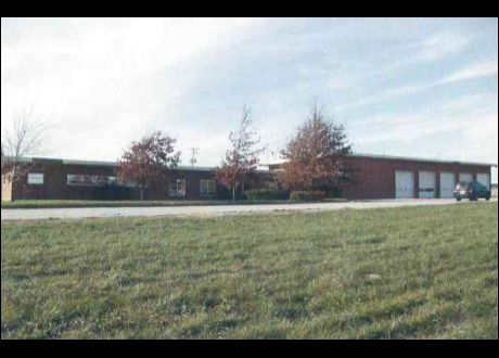
Property Record
1511 N Ohio Ave, Sedalia, MO 65301
NEARBY LISTINGS FOR SALE OR LEASE
Property Detail
1511 N Ohio Ave
108033000002007
BEG W ROW LI HWY 765 311.32' S LI N 1/2 NE, TH N 371.81', N 310.84', NW 144.69', W 533.61', S 429.68', SE 316.49', SE 272.8',
Commercialacreage
Pettis
2023
Missouri
2023
10 AC
480600
Other Market Areas
1,770 SF
Sedalia, MO
DEMOGRAPHICS near 1511 N Ohio Ave
1 Mile
3 Mile
5 Mile
2024 Total Population
1,293
22,869
31,349
2029 Population
1,345
23,524
32,090
Pop Growth 2024-2029
+ 4.02%
+ 2.86%
+ 2.36%
Average Age
37
38
39
2024 Total Households
478
9,236
12,433
HH Growth 2024-2029
+ 3.97%
+ 2.90%
+ 2.41%
Median Household Inc
$33,349
$46,876
$51,737
Avg Household Size
2.60
2.30
2.40
2024 Avg HH Vehicles
1.00
2.00
2.00
Median Home Value
$57,323
$114,713
$141,420
Median Year Built
1966
1963
1969
Nearby Places
- Restaurants
- Banks
- Shops
- Fitness
- Groceries
PUBLIC TRANSPORTATION
COMMUTER RAIL
Sedalia Amtrak Station (Lincoln Service Missouri River Runner - Amtrak, Missouri River Runner - Amtrak)
DRIVE
WALK
Distance
Sedalia Amtrak Station (Lincoln Service Missouri River Runner - Amtrak, Missouri River Runner - Amtrak)
3 min
1.1 mi
Freight Ports
Tulsa Port Of Catoosa
DRIVE
WALK
Distance
Tulsa Port Of Catoosa
319 min
275.5 mi
SALE & LEASE HISTORY
LISTING DATE
SALE/LEASE

May 18, 2018
For Sale
Nearby Properties
Address
Land Use
TOTAL SIZE
Lot Size
Zoning
Address
Land Use
TOTAL SIZE
Lot Size
Zoning
Address
Land Use
TOTAL SIZE
Lot Size
Zoning
52,605 SF
26.56 AC
Address
Land Use
TOTAL SIZE
Lot Size
Zoning
201,452 SF
15 AC
Address
Land Use
TOTAL SIZE
Lot Size
Zoning
494,190 SF
45.23 AC
Address
Land Use
TOTAL SIZE
Lot Size
Zoning
121,591 SF
15.30 AC
Address
Land Use
TOTAL SIZE
Lot Size
Zoning
69,763 SF
9.96 AC
Address
Land Use
TOTAL SIZE
Lot Size
Zoning
440,184 SF
26 AC
Address
Land Use
TOTAL SIZE
Lot Size
Zoning
49,341 SF
3.37 AC
Address
Land Use
TOTAL SIZE
Lot Size
Zoning
303,444 SF
40.75 AC
Address
Land Use
TOTAL SIZE
Lot Size
Zoning
223,284 SF
38.25 AC
Address
Land Use
TOTAL SIZE
Lot Size
Zoning
13,158 SF
9.20 AC
Address
Land Use
TOTAL SIZE
Lot Size
Zoning
11,149 SF
3.81 AC
Address
Land Use
TOTAL SIZE
Lot Size
Zoning
41,130 SF
2 AC
Address
Land Use
TOTAL SIZE
Lot Size
Zoning
8,699 SF
0.70 AC
Address
Land Use
TOTAL SIZE
Lot Size
Zoning
8,700 SF
6.62 AC
Address
Land Use
TOTAL SIZE
Lot Size
Zoning
22,950 SF
3.34 AC
Address
Land Use
TOTAL SIZE
Lot Size
Zoning
52,400 SF
4.74 AC
Address
Land Use
TOTAL SIZE
Lot Size
Zoning
2,800 SF
171.52 AC
Address
Land Use
TOTAL SIZE
Lot Size
Zoning
14,190 SF
1.58 AC
Address
Land Use
TOTAL SIZE
Lot Size
Zoning
41,054 SF
10.74 AC
Address
Land Use
TOTAL SIZE
Lot Size
Zoning
32,640 SF
2.17 AC
Address
Land Use
TOTAL SIZE
Lot Size
Zoning
63,240 SF
6.12 AC
Address
Land Use
TOTAL SIZE
Lot Size
Zoning
24,905 SF
4.13 AC
Address
Land Use
TOTAL SIZE
Lot Size
Zoning
30,000 SF
5.54 AC
Address
Land Use
TOTAL SIZE
Lot Size
Zoning
47,268 SF
7.50 AC
Address
Land Use
TOTAL SIZE
Lot Size
Zoning
31,026 SF
1.87 AC
Address
Land Use
TOTAL SIZE
Lot Size
Zoning
6,088 SF
7.02 AC
Address
Land Use
TOTAL SIZE
Lot Size
Zoning
75,245 SF
1.04 AC
Address
Land Use
TOTAL SIZE
Lot Size
Zoning
70,075 SF
7.90 AC
Address
Land Use
TOTAL SIZE
Lot Size
Zoning
12,887 SF
5.85 AC
The World's #1 Commercial Real Estate Marketplace
Connect with us
© 2025 CoStar Group
The information above has been obtained from sources believed reliable. While we do not doubt its accuracy we have not verified it and make no guarantee, warranty or representation about it. It is your responsibility to independently confirm its accuracy and completeness. Any projections, opinions, assumptions, or estimates used are for example only and do not represent the current or future performance of the property. The value of this transaction to you depends on tax and other factors which should be evaluated by your tax, financial, and legal advisors. You and your advisors should conduct a careful, independent investigation of the property to determine to your satisfaction the suitability of the property for your needs.