Property Record
1515 Coleman Loop Rd, Hillsborough, NC 27278


NEARBY LISTINGS FOR SALE OR LEASE
-
-
View all Hillsborough listings for lease on LoopNet.com
Property Detail
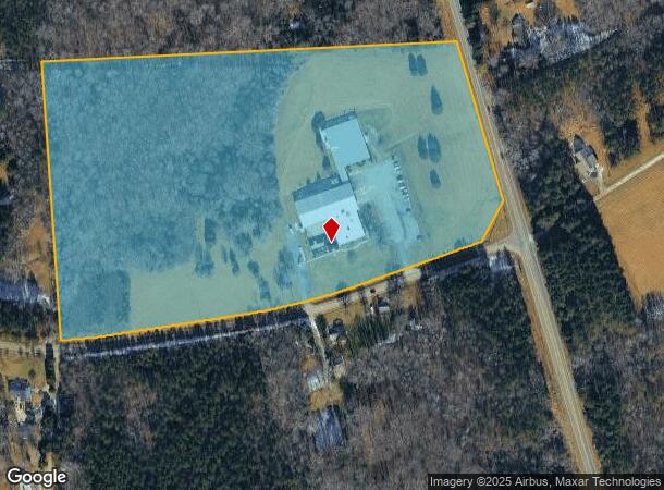
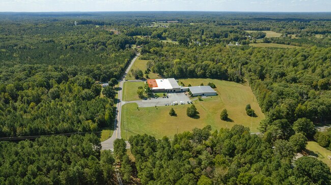
1515 Coleman Loop Rd
9865685784
Property Of Major Business Forms Inc
Industrialgeneral
NE INT SR 1332 & HWY 86 P39/33
X
Orange
3710986500J
North Carolina
0
21 AC
2025
Orange County
011103
Raleigh/Durham
19,764 SF
Durham-Chapel Hill, NC
DEMOGRAPHICS near 1515 Coleman Loop Rd
1 Mile
3 Mile
5 Mile
2024 Total Population
704
10,040
25,217
2029 Population
661
9,308
23,374
Pop Growth 2024-2029
(6.11%)
(7.29%)
(7.31%)
Average Age
42
43
42
2024 Total Households
263
4,022
10,029
HH Growth 2024-2029
(6.46%)
(7.53%)
(7.56%)
Median Household Inc
$34,757
$95,497
$89,516
Avg Household Size
2.60
2.50
2.40
2024 Avg HH Vehicles
2.00
2.00
2.00
Median Home Value
$174,589
$350,000
$306,109
Median Year Built
1985
1982
1989
Nearby Places
Map Layers
Map Styles
 Street
 Aerial
- Restaurants
- Banks
- Shops
- Fitness
- Groceries
PUBLIC TRANSPORTATION
AIRPORT
Raleigh-Durham International
DRIVE
WALK
Distance
Raleigh-Durham International
42 min
29.5 mi
Freight Ports
Virginia Port Authority - Richmond
DRIVE
WALK
Distance
Virginia Port Authority - Richmond
185 min
159.9 mi
SALE & LEASE HISTORY
LISTING DATE
SALE/LEASE

Sep 30, 2022
For Lease
Sep 25, 2016
For Lease
Oct 02, 2017
For Lease
Nov 16, 2016
For Lease
Jan 26, 2018
For Sale
Jan 26, 2018
For Sale
Aug 10, 2020
For Lease
Apr 25, 2018
For Lease
Nearby Properties
Address
Land Use
TOTAL SIZE
Lot Size
Zoning
Address
Land Use
TOTAL SIZE
Lot Size
Zoning
39,139 SF
34.34 AC
Address
Land Use
TOTAL SIZE
Lot Size
Zoning
61,329 SF
9.85 AC
Address
Land Use
TOTAL SIZE
Lot Size
Zoning
58,370 SF
7.04 AC
Address
Land Use
TOTAL SIZE
Lot Size
Zoning
144,303 SF
17.41 AC
Address
Land Use
TOTAL SIZE
Lot Size
Zoning
88,288 SF
18.13 AC
AR
Address
Land Use
TOTAL SIZE
Lot Size
Zoning
56,146 SF
11.92 AC
Address
Land Use
TOTAL SIZE
Lot Size
Zoning
40,236 SF
1.05 AC
HI
Address
Land Use
TOTAL SIZE
Lot Size
Zoning
38,810 SF
11.25 AC
Address
Land Use
TOTAL SIZE
Lot Size
Zoning
86,400 SF
10.15 AC
HI
Address
Land Use
TOTAL SIZE
Lot Size
Zoning
68,879 SF
20.38 AC
HI
Address
Land Use
TOTAL SIZE
Lot Size
Zoning
Address
Land Use
TOTAL SIZE
Lot Size
Zoning
33,114 SF
5.72 AC
HI
Address
Land Use
TOTAL SIZE
Lot Size
Zoning
47,080 SF
0.59 AC
Address
Land Use
TOTAL SIZE
Lot Size
Zoning
384 AC
ARHIPID
Address
Land Use
TOTAL SIZE
Lot Size
Zoning
22,497 SF
9.39 AC
HI
Address
Land Use
TOTAL SIZE
Lot Size
Zoning
23,892 SF
0.50 AC
Address
Land Use
TOTAL SIZE
Lot Size
Zoning
73,024 SF
10.54 AC
HI
Address
Land Use
TOTAL SIZE
Lot Size
Zoning
49,715 SF
9.26 AC
Address
Land Use
TOTAL SIZE
Lot Size
Zoning
65,235 SF
25.62 AC
HI
Address
Land Use
TOTAL SIZE
Lot Size
Zoning
7,828 SF
5.90 AC
ARHI
Address
Land Use
TOTAL SIZE
Lot Size
Zoning
6,000 SF
46.49 AC
Address
Land Use
TOTAL SIZE
Lot Size
Zoning
20,661 SF
4.08 AC
HI
Address
Land Use
TOTAL SIZE
Lot Size
Zoning
110,712 SF
1 AC
Address
Land Use
TOTAL SIZE
Lot Size
Zoning
25,766 SF
9.02 AC
Address
Land Use
TOTAL SIZE
Lot Size
Zoning
26,040 SF
9.20 AC
Address
Land Use
TOTAL SIZE
Lot Size
Zoning
11,984 SF
2.22 AC
HI
Address
Land Use
TOTAL SIZE
Lot Size
Zoning
4,352 SF
62.73 AC
Address
Land Use
TOTAL SIZE
Lot Size
Zoning
10,824 SF
0.51 AC
HI
The World's #1 Commercial Real Estate Marketplace
Connect with us
© 2026 CoStar Group
The information above has been obtained from sources believed reliable. While we do not doubt its accuracy we have not verified it and make no guarantee, warranty or representation about it. It is your responsibility to independently confirm its accuracy and completeness. Any projections, opinions, assumptions, or estimates used are for example only and do not represent the current or future performance of the property. The value of this transaction to you depends on tax and other factors which should be evaluated by your tax, financial, and legal advisors. You and your advisors should conduct a careful, independent investigation of the property to determine to your satisfaction the suitability of the property for your needs.