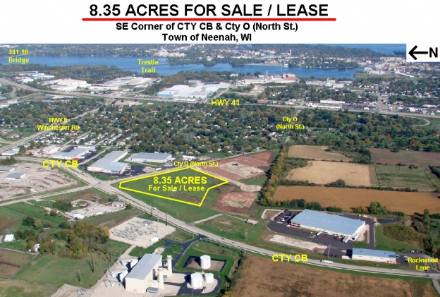
Property Record
1515 County Road O, Neenah, WI 54956
NEARBY LISTINGS FOR SALE OR LEASE
Property Detail
1515 County Road O
Oshkosh-Neenah, WI
PT SW NW & PT SE NW DESC AS LOT 1 OF CSM-7472 9.84 A.
010-0211-0101
Winnebago
Industrialgeneral
Wisconsin
X
1
55087C0430D
9.84 AC
2023
Appleton/Oshkosh
2023
Other Market Areas
003400
DEMOGRAPHICS near 1515 County Road O
1 Mile
3 Mile
5 Mile
2024 Total Population
3,007
39,072
72,204
2029 Population
3,003
39,077
72,376
Pop Growth 2024-2029
(0.13%)
+ 0.01%
+ 0.24%
Average Age
39
40
40
2024 Total Households
1,225
16,665
30,663
HH Growth 2024-2029
(0.33%)
(0.15%)
+ 0.11%
Median Household Inc
$64,767
$65,722
$66,950
Avg Household Size
2.40
2.30
2.30
2024 Avg HH Vehicles
2.00
2.00
2.00
Median Home Value
$186,800
$178,809
$188,374
Median Year Built
1973
1971
1974
Nearby Places
- Restaurants
- Banks
- Shops
- Fitness
- Groceries
PUBLIC TRANSPORTATION
AIRPORT
Appleton International
DRIVE
WALK
Distance
Appleton International
14 min
6.9 mi
Green Bay/Austin Straubel International
DRIVE
WALK
Distance
Green Bay/Austin Straubel International
44 min
35.8 mi
Freight Ports
Port Milwaukee
DRIVE
WALK
Distance
Port Milwaukee
117 min
101.0 mi
Nearby Properties
Address
Land Use
TOTAL SIZE
Lot Size
Zoning
Address
Land Use
TOTAL SIZE
Lot Size
Zoning
156.36 AC
M1
Address
Land Use
TOTAL SIZE
Lot Size
Zoning
120.73 AC
M2
Address
Land Use
TOTAL SIZE
Lot Size
Zoning
1,975 SF
2.40 AC
M2
Address
Land Use
TOTAL SIZE
Lot Size
Zoning
11.99 AC
Address
Land Use
TOTAL SIZE
Lot Size
Zoning
11.22 AC
Address
Land Use
TOTAL SIZE
Lot Size
Zoning
800 SF
19.84 AC
I1
Address
Land Use
TOTAL SIZE
Lot Size
Zoning
178,750 SF
0.43 AC
C2
Address
Land Use
TOTAL SIZE
Lot Size
Zoning
59,584 SF
12.11 AC
C1
Address
Land Use
TOTAL SIZE
Lot Size
Zoning
103,427 SF
0.56 AC
PDD
Address
Land Use
TOTAL SIZE
Lot Size
Zoning
89,042 SF
2.83 AC
C2
Address
Land Use
TOTAL SIZE
Lot Size
Zoning
9.40 AC
Address
Land Use
TOTAL SIZE
Lot Size
Zoning
89,576 SF
1.03 AC
C2
Address
Land Use
TOTAL SIZE
Lot Size
Zoning
11,340 SF
0.92 AC
C2
Address
Land Use
TOTAL SIZE
Lot Size
Zoning
105,852 SF
0.39 AC
PDD
Address
Land Use
TOTAL SIZE
Lot Size
Zoning
67.41 AC
I2
Address
Land Use
TOTAL SIZE
Lot Size
Zoning
29.32 AC
I1
Address
Land Use
TOTAL SIZE
Lot Size
Zoning
210,214 SF
16.44 AC
I1
Address
Land Use
TOTAL SIZE
Lot Size
Zoning
6.75 AC
M1
Address
Land Use
TOTAL SIZE
Lot Size
Zoning
10.42 AC
Address
Land Use
TOTAL SIZE
Lot Size
Zoning
54,690 SF
4.96 AC
I1
Address
Land Use
TOTAL SIZE
Lot Size
Zoning
15.73 AC
B5
Address
Land Use
TOTAL SIZE
Lot Size
Zoning
85,527 SF
7.79 AC
I1
Address
Land Use
TOTAL SIZE
Lot Size
Zoning
145,322 SF
11.20 AC
PDD
Address
Land Use
TOTAL SIZE
Lot Size
Zoning
92,039 SF
13.55 AC
I2
Address
Land Use
TOTAL SIZE
Lot Size
Zoning
32.60 AC
Address
Land Use
TOTAL SIZE
Lot Size
Zoning
4.33 AC
Address
Land Use
TOTAL SIZE
Lot Size
Zoning
31,400 SF
0.37 AC
PDD
Address
Land Use
TOTAL SIZE
Lot Size
Zoning
11.77 AC
R5
Address
Land Use
TOTAL SIZE
Lot Size
Zoning
22.72 AC
I1
Address
Land Use
TOTAL SIZE
Lot Size
Zoning
48,933 SF
2.80 AC
PDD
The World's #1 Commercial Real Estate Marketplace
Connect with us
© 2025 CoStar Group
The information above has been obtained from sources believed reliable. While we do not doubt its accuracy we have not verified it and make no guarantee, warranty or representation about it. It is your responsibility to independently confirm its accuracy and completeness. Any projections, opinions, assumptions, or estimates used are for example only and do not represent the current or future performance of the property. The value of this transaction to you depends on tax and other factors which should be evaluated by your tax, financial, and legal advisors. You and your advisors should conduct a careful, independent investigation of the property to determine to your satisfaction the suitability of the property for your needs.