Property Record
1519 W Airline Hwy, Waterloo, IA 50703
NEARBY LISTINGS FOR SALE OR LEASE
-
-
View all Waterloo listings for sale on LoopNet.com
Property Detail
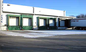
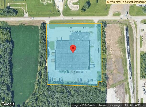
1519 W Airline Hwy
8913-10-126-008
Waterloo
Warehouse
UNPLATTED WLOO EAST N 1102 FT S 1044 FT OF E 1069 FT NW 1/4 SEC 10 T 89 R 13 EXC RD EXC E 352 FT OF S 1044 FT OF N 1102 FT OF
AE
Black Hawk
19013C0186F
Iowa
2024
11.40 AC
2024
Other Market Areas
001702
Waterloo-Cedar Falls, IA
167,053 SF
DEMOGRAPHICS near 1519 W Airline Hwy
1 Mile
3 Mile
5 Mile
2024 Total Population
1,245
16,698
72,519
2029 Population
1,228
16,524
72,033
Pop Growth 2024-2029
(1.37%)
(1.04%)
(0.67%)
Average Age
40
39
38
2024 Total Households
530
7,151
30,750
HH Growth 2024-2029
(1.32%)
(1.13%)
(0.67%)
Median Household Inc
$51,122
$50,455
$53,834
Avg Household Size
2.30
2.30
2.30
2024 Avg HH Vehicles
2.00
2.00
2.00
Median Home Value
$119,430
$120,737
$146,682
Median Year Built
1958
1955
1958
Nearby Places
- Restaurants
- Banks
- Shops
- Fitness
- Groceries
Nearby Properties
Address
Land Use
TOTAL SIZE
Lot Size
Zoning
Address
Land Use
TOTAL SIZE
Lot Size
Zoning
9,719 SF
42.81 AC
Address
Land Use
TOTAL SIZE
Lot Size
Zoning
1,355.76 AC
Address
Land Use
TOTAL SIZE
Lot Size
Zoning
171,885 SF
20 AC
Address
Land Use
TOTAL SIZE
Lot Size
Zoning
97,401 SF
21.83 AC
Address
Land Use
TOTAL SIZE
Lot Size
Zoning
41,999 SF
10.74 AC
Address
Land Use
TOTAL SIZE
Lot Size
Zoning
18,000 SF
141.74 AC
Address
Land Use
TOTAL SIZE
Lot Size
Zoning
10,016 SF
16.22 AC
Address
Land Use
TOTAL SIZE
Lot Size
Zoning
1,600 SF
9.51 AC
Address
Land Use
TOTAL SIZE
Lot Size
Zoning
26.27 AC
Address
Land Use
TOTAL SIZE
Lot Size
Zoning
74,115 SF
10.60 AC
Address
Land Use
TOTAL SIZE
Lot Size
Zoning
1,560 SF
13.92 AC
Address
Land Use
TOTAL SIZE
Lot Size
Zoning
162,000 SF
16.20 AC
Address
Land Use
TOTAL SIZE
Lot Size
Zoning
41,472 SF
5.97 AC
Address
Land Use
TOTAL SIZE
Lot Size
Zoning
360 SF
21.25 AC
Address
Land Use
TOTAL SIZE
Lot Size
Zoning
8.14 AC
Address
Land Use
TOTAL SIZE
Lot Size
Zoning
15,912 SF
2.50 AC
Address
Land Use
TOTAL SIZE
Lot Size
Zoning
14,142 SF
3.42 AC
Address
Land Use
TOTAL SIZE
Lot Size
Zoning
3,200 SF
7.83 AC
Address
Land Use
TOTAL SIZE
Lot Size
Zoning
65,668 SF
8.37 AC
Address
Land Use
TOTAL SIZE
Lot Size
Zoning
14,736 SF
1.56 AC
Address
Land Use
TOTAL SIZE
Lot Size
Zoning
8,400 SF
5.58 AC
Address
Land Use
TOTAL SIZE
Lot Size
Zoning
86,206 SF
10.60 AC
Address
Land Use
TOTAL SIZE
Lot Size
Zoning
80,000 SF
7.28 AC
Address
Land Use
TOTAL SIZE
Lot Size
Zoning
22.07 AC
Address
Land Use
TOTAL SIZE
Lot Size
Zoning
38,868 SF
7.26 AC
Address
Land Use
TOTAL SIZE
Lot Size
Zoning
7,236 SF
2.74 AC
Address
Land Use
TOTAL SIZE
Lot Size
Zoning
71,748 SF
5 AC
Address
Land Use
TOTAL SIZE
Lot Size
Zoning
11,200 SF
24.36 AC
Address
Land Use
TOTAL SIZE
Lot Size
Zoning
50,650 SF
7.29 AC
Address
Land Use
TOTAL SIZE
Lot Size
Zoning
528,634 SF
13.33 AC
The World's #1 Commercial Real Estate Marketplace
Connect with us
© 2025 CoStar Group
The information above has been obtained from sources believed reliable. While we do not doubt its accuracy we have not verified it and make no guarantee, warranty or representation about it. It is your responsibility to independently confirm its accuracy and completeness. Any projections, opinions, assumptions, or estimates used are for example only and do not represent the current or future performance of the property. The value of this transaction to you depends on tax and other factors which should be evaluated by your tax, financial, and legal advisors. You and your advisors should conduct a careful, independent investigation of the property to determine to your satisfaction the suitability of the property for your needs.