Property Record
1523 Columbia Tpke, Castleton On Hudson, NY 12033
NEARBY LISTINGS FOR SALE OR LEASE
-
-
View all Castleton On Hudson listings for sale on LoopNet.com
Property Detail
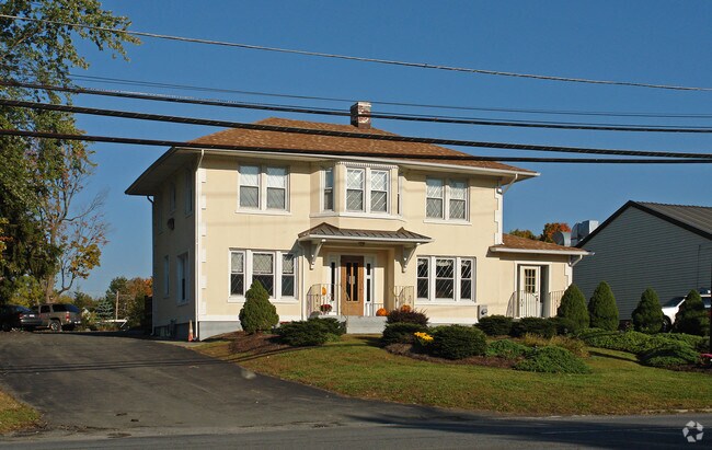
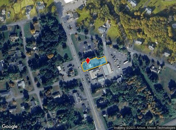
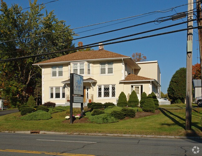
1523 Columbia Tpke
4489-178.9-2-3
COMMERCIAL & RESIDENCE.
Commercialofficeresidentialmixeduse
Rensselaer
ARE
New York
36083C0354D
3.000
2025
0.61 AC
2024
Outer Rensselaer County
052502
Albany/Schenectady/Troy
2,146 SF
Albany-Schenectady-Troy, NY
DEMOGRAPHICS near 1523 Columbia Tpke
1 Mile
3 Mile
5 Mile
2024 Total Population
3,832
14,055
32,383
2029 Population
3,812
13,945
32,106
Pop Growth 2024-2029
(0.52%)
(0.78%)
(0.86%)
Average Age
45
44
43
2024 Total Households
1,659
5,937
13,568
HH Growth 2024-2029
(0.66%)
(0.89%)
(0.98%)
Median Household Inc
$105,862
$100,852
$94,652
Avg Household Size
2.30
2.30
2.30
2024 Avg HH Vehicles
2.00
2.00
2.00
Median Home Value
$269,375
$261,687
$252,750
Median Year Built
1977
1978
1973
Nearby Places
Map Layers
Map Styles
 Street
 Aerial
- Restaurants
- Banks
- Shops
- Fitness
- Groceries
PUBLIC TRANSPORTATION
COMMUTER RAIL
Albany-Rensselaer Amtrak Station (Adirondack - Amtrak, Empire Service - Amtrak, Ethan Allen Express - Amtrak, Lake Shore Limited - Amtrak, Maple Leaf - Amtrak, Toronto - New York - Amtrak)
DRIVE
WALK
Distance
Albany-Rensselaer Amtrak Station (Adirondack - Amtrak, Empire Service - Amtrak, Ethan Allen Express - Amtrak, Lake Shore Limited - Amtrak, Maple Leaf - Amtrak, Toronto - New York - Amtrak)
11 min
5.5 mi
AIRPORT
Albany International
DRIVE
WALK
Distance
Albany International
27 min
17.1 mi
Freight Ports
Albany, NY Port
DRIVE
WALK
Distance
Albany, NY Port
17 min
11.2 mi
Nearby Properties
Address
Land Use
TOTAL SIZE
Lot Size
Zoning
Address
Land Use
TOTAL SIZE
Lot Size
Zoning
1,015,740 SF
115.47 AC
HC
Address
Land Use
TOTAL SIZE
Lot Size
Zoning
278,670 SF
55.98 AC
PD-3
Address
Land Use
TOTAL SIZE
Lot Size
Zoning
44,712 SF
25.58 AC
R-3
Address
Land Use
TOTAL SIZE
Lot Size
Zoning
99,223 SF
15.47 AC
R-B
Address
Land Use
TOTAL SIZE
Lot Size
Zoning
6,720 SF
15.68 AC
R-3
Address
Land Use
TOTAL SIZE
Lot Size
Zoning
62,712 SF
17.45 AC
B-2
Address
Land Use
TOTAL SIZE
Lot Size
Zoning
141,024 SF
13.53 AC
B-2
Address
Land Use
TOTAL SIZE
Lot Size
Zoning
10,080 SF
11.31 AC
PDD
Address
Land Use
TOTAL SIZE
Lot Size
Zoning
122,272 SF
16.71 AC
B-2
Address
Land Use
TOTAL SIZE
Lot Size
Zoning
177,492 SF
52.63 AC
R-B
Address
Land Use
TOTAL SIZE
Lot Size
Zoning
27,192 SF
8.52 AC
B-2
Address
Land Use
TOTAL SIZE
Lot Size
Zoning
5,532 SF
33.96 AC
R-40
Address
Land Use
TOTAL SIZE
Lot Size
Zoning
47,016 SF
13 AC
R-B
Address
Land Use
TOTAL SIZE
Lot Size
Zoning
4.76 AC
R-B
Address
Land Use
TOTAL SIZE
Lot Size
Zoning
10,800 SF
11.94 AC
PDD
Address
Land Use
TOTAL SIZE
Lot Size
Zoning
2,187 SF
5.06 AC
R-3
Address
Land Use
TOTAL SIZE
Lot Size
Zoning
5,050 SF
7.07 AC
R-3
Address
Land Use
TOTAL SIZE
Lot Size
Zoning
102,000 SF
11.80 AC
PD-3
Address
Land Use
TOTAL SIZE
Lot Size
Zoning
133,680 SF
34.98 AC
R-B
Address
Land Use
TOTAL SIZE
Lot Size
Zoning
66,354 SF
10.26 AC
R-20
Address
Land Use
TOTAL SIZE
Lot Size
Zoning
48,348 SF
9.78 AC
OC
Address
Land Use
TOTAL SIZE
Lot Size
Zoning
20,320 SF
4.39 AC
PD-3
Address
Land Use
TOTAL SIZE
Lot Size
Zoning
23,498 SF
4.23 AC
B-2
Address
Land Use
TOTAL SIZE
Lot Size
Zoning
21,742 SF
10 AC
R-B
Address
Land Use
TOTAL SIZE
Lot Size
Zoning
10,800 SF
6.86 AC
PDD
Address
Land Use
TOTAL SIZE
Lot Size
Zoning
15,000 SF
2.53 AC
PDD
Address
Land Use
TOTAL SIZE
Lot Size
Zoning
0.42 AC
Address
Land Use
TOTAL SIZE
Lot Size
Zoning
8.41 AC
R-40
Address
Land Use
TOTAL SIZE
Lot Size
Zoning
Address
Land Use
TOTAL SIZE
Lot Size
Zoning
3.84 AC
R-40
The World's #1 Commercial Real Estate Marketplace
Connect with us
© 2026 CoStar Group
The information above has been obtained from sources believed reliable. While we do not doubt its accuracy we have not verified it and make no guarantee, warranty or representation about it. It is your responsibility to independently confirm its accuracy and completeness. Any projections, opinions, assumptions, or estimates used are for example only and do not represent the current or future performance of the property. The value of this transaction to you depends on tax and other factors which should be evaluated by your tax, financial, and legal advisors. You and your advisors should conduct a careful, independent investigation of the property to determine to your satisfaction the suitability of the property for your needs.