Property Record
1530 S Bound Rd, Gaston, SC 29053
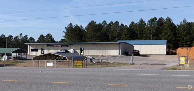

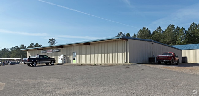
Property Detail
1530 S Bound Rd
Storebuilding
LEXINGTON
LR
South Carolina
B and X Area of moderate flood hazard, usually the area between the limits of the 100-year and 500-year floods.
2 AC
2025
Outlying Lexington County
2024
Columbia
020806
Columbia, SC
7,920 SF
011900-02-167
NEARBY LISTINGS FOR SALE OR LEASE
DEMOGRAPHICS near 1530 S Bound Rd
1 mile
3 mile
5 mile
2025 Total Population
391
4,884
14,698
2030 Population
418
5,218
15,705
Pop Growth 2025-2030
+ 6.91%
+ 6.84%
+ 6.85%
Average Age
41
41
41
2025 Total Households
151
1,910
5,612
HH Growth 2025-2030
+ 6.62%
+ 6.96%
+ 6.99%
Median Household Inc
$46,250
$50,189
$52,338
Avg Household Size
2.50
2.50
2.50
2025 Avg HH Vehicles
2.00
2.00
2.00
Median Home Value
$139,394
$140,187
$137,940
Median Year Built
1986
1988
1991
Nearby Places
Map Layers
Map Styles
 Street
 Aerial
Layers
 Traffic
 Biking
Places
Listings with unknown addresses are not visible on the map
- Restaurants
- Banks
- Shops
- Fitness
- Groceries
PUBLIC TRANSPORTATION
AIRPORT
Columbia Metro
Drive
Walk
Distance
Columbia Metro
31 min
19.2 mi
Freight Ports
North Charleston Terminal
Drive
Walk
Distance
North Charleston Terminal
114 min
92.9 mi
Nearby Properties
Address
Land Use
TOTAL SIZE
Lot Size
Zoning
Address
Land Use
TOTAL SIZE
Lot Size
Zoning
39,216 SF
271.81 AC
ID
Address
Land Use
TOTAL SIZE
Lot Size
Zoning
64,200 SF
8.53 AC
LR
Address
Land Use
TOTAL SIZE
Lot Size
Zoning
2,304 SF
0.85 AC
LR
Address
Land Use
TOTAL SIZE
Lot Size
Zoning
12,752 SF
0.52 AC
NA
Address
Land Use
TOTAL SIZE
Lot Size
Zoning
111.56 AC
ID
Address
Land Use
TOTAL SIZE
Lot Size
Zoning
15,911 SF
4.80 AC
Address
Land Use
TOTAL SIZE
Lot Size
Zoning
145.70 AC
Address
Land Use
TOTAL SIZE
Lot Size
Zoning
12,871 SF
2.44 AC
Address
Land Use
TOTAL SIZE
Lot Size
Zoning
9,373 SF
0.85 AC
ID
Address
Land Use
TOTAL SIZE
Lot Size
Zoning
134.04 AC
LR
Address
Land Use
TOTAL SIZE
Lot Size
Zoning
2,812 SF
1.16 AC
Address
Land Use
TOTAL SIZE
Lot Size
Zoning
5,048 SF
1.06 AC
LR
Address
Land Use
TOTAL SIZE
Lot Size
Zoning
3,829 SF
1.04 AC
LR
Address
Land Use
TOTAL SIZE
Lot Size
Zoning
176 AC
LR
Address
Land Use
TOTAL SIZE
Lot Size
Zoning
3,600 SF
1.05 AC
Address
Land Use
TOTAL SIZE
Lot Size
Zoning
8,075 SF
28.95 AC
RD
Address
Land Use
TOTAL SIZE
Lot Size
Zoning
3,036 SF
0.52 AC
LR
Address
Land Use
TOTAL SIZE
Lot Size
Zoning
147.01 AC
Address
Land Use
TOTAL SIZE
Lot Size
Zoning
Address
Land Use
TOTAL SIZE
Lot Size
Zoning
38.74 AC
LR
Address
Land Use
TOTAL SIZE
Lot Size
Zoning
2.27 AC
Address
Land Use
TOTAL SIZE
Lot Size
Zoning
2,125 SF
0.94 AC
LR
Address
Land Use
TOTAL SIZE
Lot Size
Zoning
2,500 SF
2.53 AC
Address
Land Use
TOTAL SIZE
Lot Size
Zoning
2,814 SF
0.62 AC
LR
Address
Land Use
TOTAL SIZE
Lot Size
Zoning
108.87 AC
Address
Land Use
TOTAL SIZE
Lot Size
Zoning
6,350 SF
0.43 AC
Address
Land Use
TOTAL SIZE
Lot Size
Zoning
1,880 SF
10.48 AC
LR
Address
Land Use
TOTAL SIZE
Lot Size
Zoning
84.47 AC
Address
Land Use
TOTAL SIZE
Lot Size
Zoning
192.54 AC
Address
Land Use
TOTAL SIZE
Lot Size
Zoning
5,053 SF
2 AC
ID
The World's #1 Commercial Real Estate Marketplace
Connect with us
© 2026 CoStar Group
The information above has been obtained from sources believed reliable. While we do not doubt its accuracy we have not verified it and make no guarantee, warranty or representation about it. It is your responsibility to independently confirm its accuracy and completeness. Any projections, opinions, assumptions, or estimates used are for example only and do not represent the current or future performance of the property. The value of this transaction to you depends on tax and other factors which should be evaluated by your tax, financial, and legal advisors. You and your advisors should conduct a careful, independent investigation of the property to determine to your satisfaction the suitability of the property for your needs.