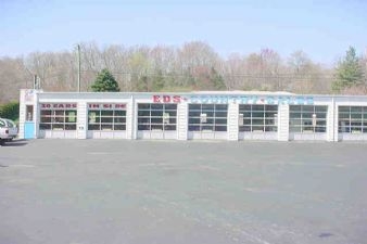
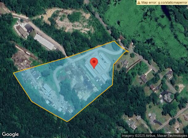
Property Record
410 Maple Ave, Uncasville, CT 06382
NEARBY LISTINGS FOR SALE OR LEASE
Property Detail
410 Maple Ave
MONT-000031-000002-A000000
New London
Commercialnec
Connecticut
X
a
09011C0334G
10.69 AC
2024
New London
2024
Hartford
695201
Norwich-New London, CT
DEMOGRAPHICS near 410 Maple Ave
1 Mile
3 Mile
5 Mile
2024 Total Population
1,266
11,745
36,453
2029 Population
1,241
11,716
36,390
Pop Growth 2024-2029
(1.97%)
(0.25%)
(0.17%)
Average Age
43
43
42
2024 Total Households
526
4,249
14,016
HH Growth 2024-2029
(2.09%)
(0.71%)
(0.30%)
Median Household Inc
$91,029
$85,903
$87,945
Avg Household Size
2.40
2.40
2.40
2024 Avg HH Vehicles
2.00
2.00
2.00
Median Home Value
$234,910
$238,283
$248,039
Median Year Built
1981
1971
1968
Nearby Places
- Restaurants
- Banks
- Shops
- Fitness
- Groceries
PUBLIC TRANSPORTATION
COMMUTER RAIL
New London (Shore Line East - Shore Line East)
DRIVE
WALK
Distance
New London (Shore Line East - Shore Line East)
17 min
9.0 mi
Freight Ports
Port of Davisville, RI
DRIVE
WALK
Distance
Port of Davisville, RI
82 min
58.8 mi
SALE & LEASE HISTORY
LISTING DATE
SALE/LEASE

Apr 16, 2021
For Sale
Nearby Properties
Address
Land Use
TOTAL SIZE
Lot Size
Zoning
Address
Land Use
TOTAL SIZE
Lot Size
Zoning
Address
Land Use
TOTAL SIZE
Lot Size
Zoning
170,964 SF
68.71 AC
GOV
Address
Land Use
TOTAL SIZE
Lot Size
Zoning
Address
Land Use
TOTAL SIZE
Lot Size
Zoning
113.19 AC
C2/OZ
Address
Land Use
TOTAL SIZE
Lot Size
Zoning
22.87 AC
C-2
Address
Land Use
TOTAL SIZE
Lot Size
Zoning
102,477 SF
22.51 AC
C-2
Address
Land Use
TOTAL SIZE
Lot Size
Zoning
4,415 SF
128.73 AC
R40
Address
Land Use
TOTAL SIZE
Lot Size
Zoning
62,316 SF
18.12 AC
GOV
Address
Land Use
TOTAL SIZE
Lot Size
Zoning
150,052 SF
IND
Address
Land Use
TOTAL SIZE
Lot Size
Zoning
35.36 AC
RSRVT
Address
Land Use
TOTAL SIZE
Lot Size
Zoning
28.40 AC
RU120
Address
Land Use
TOTAL SIZE
Lot Size
Zoning
73,404 SF
19.27 AC
GOV
Address
Land Use
TOTAL SIZE
Lot Size
Zoning
6.54 AC
GOV
Address
Land Use
TOTAL SIZE
Lot Size
Zoning
34,436 SF
19.52 AC
IND
Address
Land Use
TOTAL SIZE
Lot Size
Zoning
18.90 AC
RSRVT
Address
Land Use
TOTAL SIZE
Lot Size
Zoning
18,015 SF
17.16 AC
GOV
Address
Land Use
TOTAL SIZE
Lot Size
Zoning
46,011 SF
4.96 AC
C-2
Address
Land Use
TOTAL SIZE
Lot Size
Zoning
47,715 SF
3.41 AC
C-2
Address
Land Use
TOTAL SIZE
Lot Size
Zoning
6 AC
IND
Address
Land Use
TOTAL SIZE
Lot Size
Zoning
10.46 AC
RSRVT
Address
Land Use
TOTAL SIZE
Lot Size
Zoning
12,950 SF
3.30 AC
C-1
Address
Land Use
TOTAL SIZE
Lot Size
Zoning
12.02 AC
R20-M
Address
Land Use
TOTAL SIZE
Lot Size
Zoning
26,956 SF
2.07 AC
C-1
Address
Land Use
TOTAL SIZE
Lot Size
Zoning
4.77 AC
R20
Address
Land Use
TOTAL SIZE
Lot Size
Zoning
243.10 AC
RU120
Address
Land Use
TOTAL SIZE
Lot Size
Zoning
16.58 AC
GOV
Address
Land Use
TOTAL SIZE
Lot Size
Zoning
9.41 AC
LI
Address
Land Use
TOTAL SIZE
Lot Size
Zoning
3.06 AC
R20
Address
Land Use
TOTAL SIZE
Lot Size
Zoning
21,054 SF
46.51 AC
GOV
Address
Land Use
TOTAL SIZE
Lot Size
Zoning
22.72 AC
GOV
The World's #1 Commercial Real Estate Marketplace
Connect with us
© 2025 CoStar Group
The information above has been obtained from sources believed reliable. While we do not doubt its accuracy we have not verified it and make no guarantee, warranty or representation about it. It is your responsibility to independently confirm its accuracy and completeness. Any projections, opinions, assumptions, or estimates used are for example only and do not represent the current or future performance of the property. The value of this transaction to you depends on tax and other factors which should be evaluated by your tax, financial, and legal advisors. You and your advisors should conduct a careful, independent investigation of the property to determine to your satisfaction the suitability of the property for your needs.