Property Record
15313 Kinsman Rd, Cleveland, OH 44120
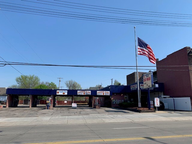
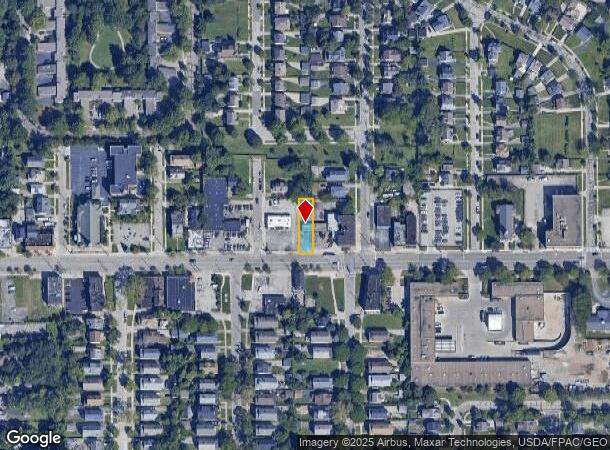
This Property Is For Sale
NEARBY LISTINGS FOR SALE OR LEASE
-
-
View all Cleveland listings for sale on LoopNet.com
Property Detail
15313 Kinsman Rd
Cleveland-Elyria, OH
Vans #19
130-19-007
42 VANS #19 S/L 151 SEP 0150 ALL
Carwash
Cuyahoga
X
Ohio
39035C0204E
150
2024
0.15 AC
2024
East
119900
Cleveland
1,500 SF
DEMOGRAPHICS near 15313 Kinsman Rd
1 Mile
3 Mile
5 Mile
2024 Total Population
21,322
126,419
323,328
2029 Population
20,807
123,427
317,139
Pop Growth 2024-2029
(2.42%)
(2.37%)
(1.91%)
Average Age
40
41
40
2024 Total Households
9,193
56,120
139,625
HH Growth 2024-2029
(2.59%)
(2.58%)
(2.02%)
Median Household Inc
$43,075
$48,779
$43,405
Avg Household Size
2.20
2.20
2.20
2024 Avg HH Vehicles
1.00
1.00
1.00
Median Home Value
$109,571
$122,709
$110,423
Median Year Built
1946
1948
1949
Nearby Places
- Restaurants
- Banks
- Shops
- Fitness
- Groceries
PUBLIC TRANSPORTATION
TRANSIT/SUBWAY
Ashby (Blue Line - Greater Cleveland Regional Transit Authority Rapid Transit (The Rapid))
DRIVE
WALK
Distance
Ashby (Blue Line - Greater Cleveland Regional Transit Authority Rapid Transit (The Rapid))
1 min
5 min
0.3 mi
Onaway (Blue Line - Greater Cleveland Regional Transit Authority Rapid Transit (The Rapid))
DRIVE
WALK
Distance
Onaway (Blue Line - Greater Cleveland Regional Transit Authority Rapid Transit (The Rapid))
2 min
11 min
0.6 mi
Lee (Blue Line) (Blue Line - Greater Cleveland Regional Transit Authority Rapid Transit (The Rapid))
DRIVE
WALK
Distance
Lee (Blue Line) (Blue Line - Greater Cleveland Regional Transit Authority Rapid Transit (The Rapid))
2 min
14 min
0.6 mi
Avalon (Blue Line - Greater Cleveland Regional Transit Authority Rapid Transit (The Rapid))
DRIVE
WALK
Distance
Avalon (Blue Line - Greater Cleveland Regional Transit Authority Rapid Transit (The Rapid))
2 min
19 min
0.9 mi
Southington (Blue Line) (Blue Line - Greater Cleveland Regional Transit Authority Rapid Transit (The Rapid))
DRIVE
WALK
Distance
Southington (Blue Line) (Blue Line - Greater Cleveland Regional Transit Authority Rapid Transit (The Rapid))
2 min
17 min
0.9 mi
COMMUTER RAIL
Rockside (National Park Scenic Railway - Cuyahoga Valley Scenic Railroad)
DRIVE
WALK
Distance
Rockside (National Park Scenic Railway - Cuyahoga Valley Scenic Railroad)
19 min
8.0 mi
Canal Exploration Center (National Park Scenic Railway - Cuyahoga Valley Scenic Railroad)
DRIVE
WALK
Distance
Canal Exploration Center (National Park Scenic Railway - Cuyahoga Valley Scenic Railroad)
21 min
8.9 mi
AIRPORT
Cleveland-Hopkins International
DRIVE
WALK
Distance
Cleveland-Hopkins International
33 min
18.0 mi
Freight Ports
Port of Toledo
DRIVE
WALK
Distance
Port of Toledo
146 min
118.6 mi
Nearby Properties
Address
Land Use
TOTAL SIZE
Lot Size
Zoning
Address
Land Use
TOTAL SIZE
Lot Size
Zoning
53.85 AC
2F
Address
Land Use
TOTAL SIZE
Lot Size
Zoning
1,066,853 SF
42.18 AC
U-5
Address
Land Use
TOTAL SIZE
Lot Size
Zoning
230,820 SF
41.47 AC
UI
Address
Land Use
TOTAL SIZE
Lot Size
Zoning
475,904 SF
8.04 AC
U-7A
Address
Land Use
TOTAL SIZE
Lot Size
Zoning
682,144 SF
99.58 AC
C-2
Address
Land Use
TOTAL SIZE
Lot Size
Zoning
233,767 SF
36.30 AC
U-1A1
Address
Land Use
TOTAL SIZE
Lot Size
Zoning
440,004 SF
4.25 AC
S2
Address
Land Use
TOTAL SIZE
Lot Size
Zoning
333,582 SF
3.67 AC
U-1A1
Address
Land Use
TOTAL SIZE
Lot Size
Zoning
413,626 SF
21.95 AC
S2
Address
Land Use
TOTAL SIZE
Lot Size
Zoning
221,406 SF
12.05 AC
2F
Address
Land Use
TOTAL SIZE
Lot Size
Zoning
0.33 AC
MF-1
Address
Land Use
TOTAL SIZE
Lot Size
Zoning
249,712 SF
22.69 AC
I
Address
Land Use
TOTAL SIZE
Lot Size
Zoning
65,783 SF
2.43 AC
MF3+
Address
Land Use
TOTAL SIZE
Lot Size
Zoning
105,215 SF
5.42 AC
PF
Address
Land Use
TOTAL SIZE
Lot Size
Zoning
110,000 SF
0.84 AC
Address
Land Use
TOTAL SIZE
Lot Size
Zoning
178,654 SF
2.69 AC
Address
Land Use
TOTAL SIZE
Lot Size
Zoning
256,546 SF
25.35 AC
U-1
Address
Land Use
TOTAL SIZE
Lot Size
Zoning
153,560 SF
32.47 AC
I
Address
Land Use
TOTAL SIZE
Lot Size
Zoning
155,896 SF
16.38 AC
Address
Land Use
TOTAL SIZE
Lot Size
Zoning
87,403 SF
8.33 AC
2F
Address
Land Use
TOTAL SIZE
Lot Size
Zoning
164,109 SF
8.89 AC
U-1A1
Address
Land Use
TOTAL SIZE
Lot Size
Zoning
106,341 SF
30.48 AC
MF-1
Address
Land Use
TOTAL SIZE
Lot Size
Zoning
191,322 SF
23.60 AC
1F
Address
Land Use
TOTAL SIZE
Lot Size
Zoning
15,154 SF
9.24 AC
SI
Address
Land Use
TOTAL SIZE
Lot Size
Zoning
134,230 SF
7.84 AC
MF3+
Address
Land Use
TOTAL SIZE
Lot Size
Zoning
17,124 SF
147.11 AC
R-1
Address
Land Use
TOTAL SIZE
Lot Size
Zoning
176,175 SF
21 AC
AA
Address
Land Use
TOTAL SIZE
Lot Size
Zoning
91,802 SF
1.40 AC
LR
Address
Land Use
TOTAL SIZE
Lot Size
Zoning
64,309 SF
3.91 AC
RO
Address
Land Use
TOTAL SIZE
Lot Size
Zoning
4,160 SF
1.84 AC
U-6
The World's #1 Commercial Real Estate Marketplace
Connect with us
© 2025 CoStar Group
The information above has been obtained from sources believed reliable. While we do not doubt its accuracy we have not verified it and make no guarantee, warranty or representation about it. It is your responsibility to independently confirm its accuracy and completeness. Any projections, opinions, assumptions, or estimates used are for example only and do not represent the current or future performance of the property. The value of this transaction to you depends on tax and other factors which should be evaluated by your tax, financial, and legal advisors. You and your advisors should conduct a careful, independent investigation of the property to determine to your satisfaction the suitability of the property for your needs.