Property Record
1536 Us Highway 70 E, Kinston, NC 28501
NEARBY LISTINGS FOR SALE OR LEASE
-
-
View all Kinston listings for sale on LoopNet.com
Property Detail
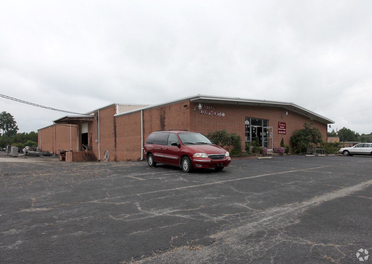
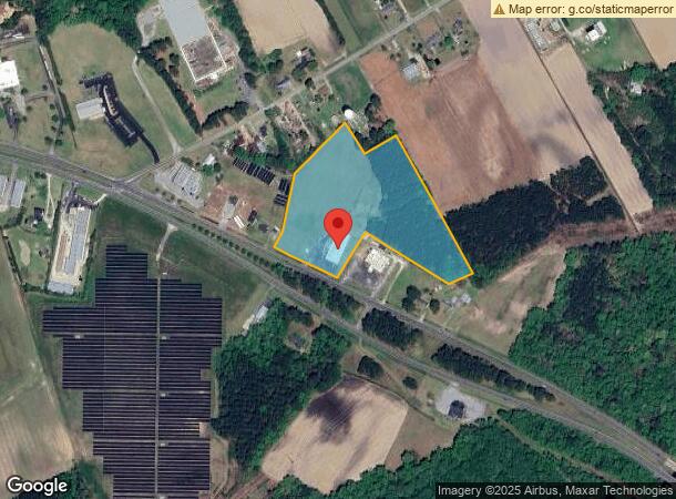
1536 Us Highway 70 E
453403332246
1536 HWY 70 EAST EASTERN EQUIPMENT CO
Timberlandforesttreesagricultural
Lenoir
X
North Carolina
3720453400K
12.99 AC
2024
North Carolina Southeast Area
2024
Other Market Areas
011400
Kinston, NC
14,400 SF
DEMOGRAPHICS near 1536 Us Highway 70 E
1 Mile
3 Mile
5 Mile
2024 Total Population
143
8,589
21,933
2029 Population
141
8,812
21,975
Pop Growth 2024-2029
(1.40%)
+ 2.60%
+ 0.19%
Average Age
44
40
42
2024 Total Households
63
3,904
9,552
HH Growth 2024-2029
(1.59%)
+ 2.56%
+ 0.23%
Median Household Inc
$74,463
$24,687
$32,569
Avg Household Size
2.30
2.10
2.20
2024 Avg HH Vehicles
3.00
1.00
2.00
Median Home Value
$144,285
$80,429
$91,069
Median Year Built
1977
1969
1968
Nearby Places
- Restaurants
- Banks
- Shops
- Fitness
- Groceries
PUBLIC TRANSPORTATION
AIRPORT
Albert J Ellis
DRIVE
WALK
Distance
Albert J Ellis
62 min
36.0 mi
Pitt-Greenville
DRIVE
WALK
Distance
Pitt-Greenville
50 min
38.1 mi
Freight Ports
Port of Morehead City
DRIVE
WALK
Distance
Port of Morehead City
104 min
73.4 mi
Nearby Properties
Address
Land Use
TOTAL SIZE
Lot Size
Zoning
Address
Land Use
TOTAL SIZE
Lot Size
Zoning
217,381 SF
77.79 AC
O&I
Address
Land Use
TOTAL SIZE
Lot Size
Zoning
166,712 SF
23.48 AC
RA8
Address
Land Use
TOTAL SIZE
Lot Size
Zoning
525,504 SF
228 AC
I1
Address
Land Use
TOTAL SIZE
Lot Size
Zoning
139,392 SF
2.19 AC
RA6
Address
Land Use
TOTAL SIZE
Lot Size
Zoning
122,274 SF
1.86 AC
B2
Address
Land Use
TOTAL SIZE
Lot Size
Zoning
65,100 SF
1.91 AC
B2
Address
Land Use
TOTAL SIZE
Lot Size
Zoning
65,344 SF
27.42 AC
Address
Land Use
TOTAL SIZE
Lot Size
Zoning
69,696 SF
0.32 AC
B2
Address
Land Use
TOTAL SIZE
Lot Size
Zoning
73,536 SF
5.38 AC
B1
Address
Land Use
TOTAL SIZE
Lot Size
Zoning
106,276 SF
8.84 AC
RA5
Address
Land Use
TOTAL SIZE
Lot Size
Zoning
77,500 SF
1.30 AC
B2
Address
Land Use
TOTAL SIZE
Lot Size
Zoning
115.74 AC
RA12
Address
Land Use
TOTAL SIZE
Lot Size
Zoning
83,088 SF
1.19 AC
B2
Address
Land Use
TOTAL SIZE
Lot Size
Zoning
25,885 SF
88.62 AC
RA6
Address
Land Use
TOTAL SIZE
Lot Size
Zoning
39,450 SF
1.02 AC
B2
Address
Land Use
TOTAL SIZE
Lot Size
Zoning
12.35 AC
RA5
Address
Land Use
TOTAL SIZE
Lot Size
Zoning
60,762 SF
57.80 AC
I1
Address
Land Use
TOTAL SIZE
Lot Size
Zoning
15,918 SF
2.53 AC
RO
Address
Land Use
TOTAL SIZE
Lot Size
Zoning
9.44 AC
RA5
Address
Land Use
TOTAL SIZE
Lot Size
Zoning
6,760 SF
147.39 AC
RA6
Address
Land Use
TOTAL SIZE
Lot Size
Zoning
6,096 SF
5 AC
Address
Land Use
TOTAL SIZE
Lot Size
Zoning
136,296 SF
11.60 AC
I1
Address
Land Use
TOTAL SIZE
Lot Size
Zoning
32,409 SF
19.02 AC
I1
Address
Land Use
TOTAL SIZE
Lot Size
Zoning
22,124 SF
Address
Land Use
TOTAL SIZE
Lot Size
Zoning
30,468 SF
0.75 AC
B2
Address
Land Use
TOTAL SIZE
Lot Size
Zoning
3,610 SF
4 AC
B1
Address
Land Use
TOTAL SIZE
Lot Size
Zoning
5,324 SF
1.22 AC
IB
Address
Land Use
TOTAL SIZE
Lot Size
Zoning
24,084 SF
2.53 AC
B1
Address
Land Use
TOTAL SIZE
Lot Size
Zoning
9,620 SF
22.71 AC
RA6
Address
Land Use
TOTAL SIZE
Lot Size
Zoning
1,174 AC
The World's #1 Commercial Real Estate Marketplace
Connect with us
© 2025 CoStar Group
The information above has been obtained from sources believed reliable. While we do not doubt its accuracy we have not verified it and make no guarantee, warranty or representation about it. It is your responsibility to independently confirm its accuracy and completeness. Any projections, opinions, assumptions, or estimates used are for example only and do not represent the current or future performance of the property. The value of this transaction to you depends on tax and other factors which should be evaluated by your tax, financial, and legal advisors. You and your advisors should conduct a careful, independent investigation of the property to determine to your satisfaction the suitability of the property for your needs.