Property Record
1540 Maple Ave, Burlington, NC 27215

This Property Is For Sale
NEARBY LISTINGS FOR SALE OR LEASE
Property Detail
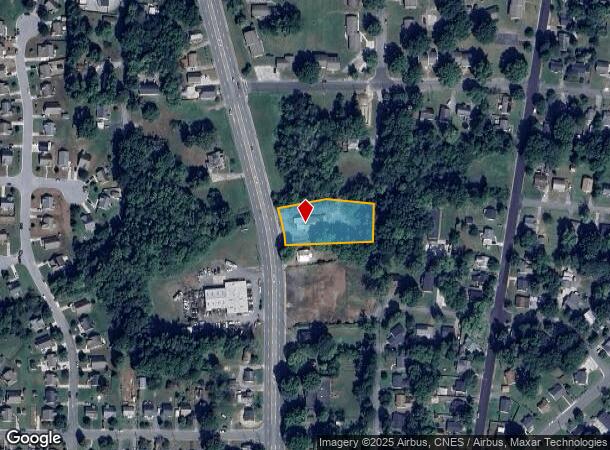
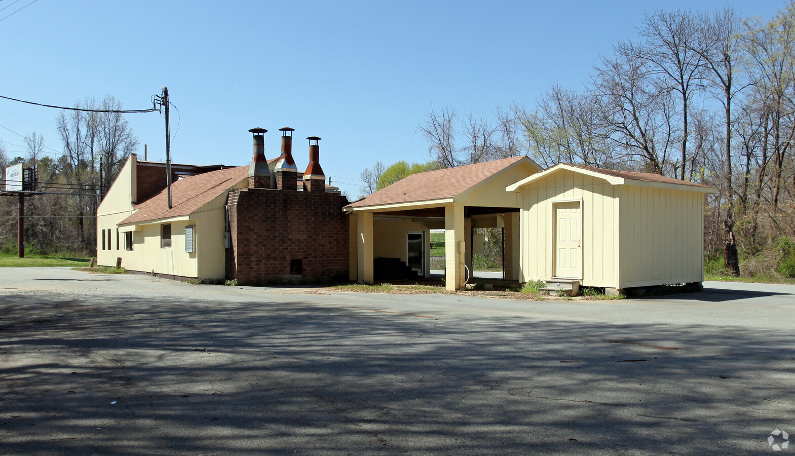
1540 Maple Ave
132981
MAPLE AVE 117-485-89
Restaurantbuilding
Alamance
AE
North Carolina
3710887400K
0.86 AC
2024
South Burlington
2024
Greensboro/Winston-Salem
020802
Burlington, NC
2,164 SF
DEMOGRAPHICS near 1540 Maple Ave
1 Mile
3 Mile
5 Mile
2024 Total Population
8,464
59,031
96,035
2029 Population
9,125
63,746
103,781
Pop Growth 2024-2029
+ 7.81%
+ 7.99%
+ 8.07%
Average Age
38
40
40
2024 Total Households
3,371
24,156
38,439
HH Growth 2024-2029
+ 7.98%
+ 8.16%
+ 8.28%
Median Household Inc
$35,894
$45,927
$51,370
Avg Household Size
2.40
2.30
2.40
2024 Avg HH Vehicles
2.00
2.00
2.00
Median Home Value
$117,296
$147,294
$172,984
Median Year Built
1961
1972
1978
Nearby Places
- Restaurants
- Banks
- Shops
- Fitness
- Groceries
PUBLIC TRANSPORTATION
COMMUTER RAIL
Burlington Station (Piedmont - North Carolina by Train (NC Train))
DRIVE
WALK
Distance
Burlington Station (Piedmont - North Carolina by Train (NC Train))
3 min
1.7 mi
AIRPORT
Piedmont Triad International
DRIVE
WALK
Distance
Piedmont Triad International
46 min
32.7 mi
Freight Ports
Virginia Port Authority - Richmond
DRIVE
WALK
Distance
Virginia Port Authority - Richmond
203 min
177.6 mi
Nearby Properties
Address
Land Use
TOTAL SIZE
Lot Size
Zoning
Address
Land Use
TOTAL SIZE
Lot Size
Zoning
177,145 SF
47.79 AC
R 15
Address
Land Use
TOTAL SIZE
Lot Size
Zoning
27,803 SF
13.10 AC
B 2
Address
Land Use
TOTAL SIZE
Lot Size
Zoning
48,136 SF
14.57 AC
B 2
Address
Land Use
TOTAL SIZE
Lot Size
Zoning
2,315 SF
55.25 AC
I 1
Address
Land Use
TOTAL SIZE
Lot Size
Zoning
36,678 SF
17.48 AC
CR
Address
Land Use
TOTAL SIZE
Lot Size
Zoning
5,888 SF
24.60 AC
MF A
Address
Land Use
TOTAL SIZE
Lot Size
Zoning
27,803 SF
11.53 AC
Address
Land Use
TOTAL SIZE
Lot Size
Zoning
40,220 SF
12.45 AC
MF A
Address
Land Use
TOTAL SIZE
Lot Size
Zoning
316,032 SF
52.87 AC
I1
Address
Land Use
TOTAL SIZE
Lot Size
Zoning
12,600 SF
44.61 AC
Address
Land Use
TOTAL SIZE
Lot Size
Zoning
153,642 SF
73.50 AC
Address
Land Use
TOTAL SIZE
Lot Size
Zoning
714,245 SF
109.43 AC
I 1
Address
Land Use
TOTAL SIZE
Lot Size
Zoning
50,000 SF
76.02 AC
I 1A
Address
Land Use
TOTAL SIZE
Lot Size
Zoning
110,612 SF
1 AC
B 3
Address
Land Use
TOTAL SIZE
Lot Size
Zoning
12,960 SF
11.35 AC
R MF
Address
Land Use
TOTAL SIZE
Lot Size
Zoning
34,480 SF
42.20 AC
OI
Address
Land Use
TOTAL SIZE
Lot Size
Zoning
6,572 SF
10.77 AC
MF A
Address
Land Use
TOTAL SIZE
Lot Size
Zoning
43,680 SF
5.77 AC
Address
Land Use
TOTAL SIZE
Lot Size
Zoning
19,872 SF
9.80 AC
Address
Land Use
TOTAL SIZE
Lot Size
Zoning
71,962 SF
5.98 AC
O I
Address
Land Use
TOTAL SIZE
Lot Size
Zoning
19,168 SF
18.69 AC
MF A
Address
Land Use
TOTAL SIZE
Lot Size
Zoning
216,968 SF
25.88 AC
CB
Address
Land Use
TOTAL SIZE
Lot Size
Zoning
40,440 SF
23.57 AC
R 9
Address
Land Use
TOTAL SIZE
Lot Size
Zoning
101,469 SF
4.28 AC
CR
Address
Land Use
TOTAL SIZE
Lot Size
Zoning
30,000 SF
3.48 AC
R 15
Address
Land Use
TOTAL SIZE
Lot Size
Zoning
23,268 SF
6.11 AC
Address
Land Use
TOTAL SIZE
Lot Size
Zoning
47,520 SF
1.44 AC
B 2
Address
Land Use
TOTAL SIZE
Lot Size
Zoning
17,073 SF
7.59 AC
R 9
Address
Land Use
TOTAL SIZE
Lot Size
Zoning
15,512 SF
6.54 AC
MF A
Address
Land Use
TOTAL SIZE
Lot Size
Zoning
9,008 SF
6.23 AC
R MF
The World's #1 Commercial Real Estate Marketplace
Connect with us
© 2025 CoStar Group
The information above has been obtained from sources believed reliable. While we do not doubt its accuracy we have not verified it and make no guarantee, warranty or representation about it. It is your responsibility to independently confirm its accuracy and completeness. Any projections, opinions, assumptions, or estimates used are for example only and do not represent the current or future performance of the property. The value of this transaction to you depends on tax and other factors which should be evaluated by your tax, financial, and legal advisors. You and your advisors should conduct a careful, independent investigation of the property to determine to your satisfaction the suitability of the property for your needs.