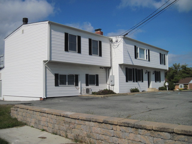
Property Record
155 Stanton Christiana Rd, Newark, DE 19702
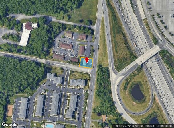
NEARBY LISTINGS FOR SALE OR LEASE
Property Detail
155 Stanton Christiana Rd
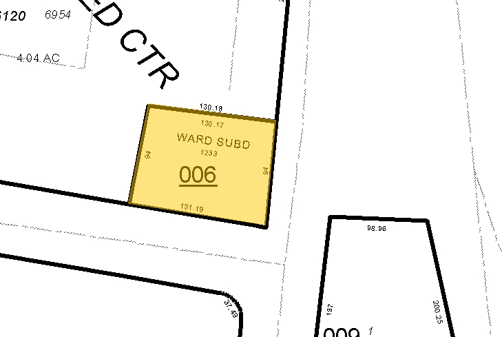
09-024.00-006
Ward Subd
Officebuilding
BEG AT OSAGE ORANGE TREE ON WLY SIDE OF OLD BALTIMORE PIKE RUNNING BETSTANTON &
X
New Castle
10003C0145K
Delaware
2024
0.29 AC
2024
South New Castle County
013800
Philadelphia
3,460 SF
Philadelphia-Camden-Wilmington, PA-NJ-DE-MD
DEMOGRAPHICS near 155 Stanton Christiana Rd
1 Mile
3 Mile
5 Mile
2024 Total Population
3,152
77,055
200,230
2029 Population
3,213
78,004
203,309
Pop Growth 2024-2029
+ 1.94%
+ 1.23%
+ 1.54%
Average Age
37
39
39
2024 Total Households
1,318
30,943
77,053
HH Growth 2024-2029
+ 1.97%
+ 1.31%
+ 1.60%
Median Household Inc
$91,095
$66,956
$68,485
Avg Household Size
2.40
2.40
2.50
2024 Avg HH Vehicles
2.00
2.00
2.00
Median Home Value
$266,801
$243,453
$253,596
Median Year Built
1982
1980
1977
Nearby Places
- Restaurants
- Banks
- Shops
- Fitness
- Groceries
PUBLIC TRANSPORTATION
COMMUTER RAIL
Churchmans Crossing (R2 - Southeastern Pennsylvania Transportation Authority Regional Rail (SEPTA Regional Rail))
DRIVE
WALK
Distance
Churchmans Crossing (R2 - Southeastern Pennsylvania Transportation Authority Regional Rail (SEPTA Regional Rail))
5 min
3.3 mi
Newark (R2 - Southeastern Pennsylvania Transportation Authority Regional Rail (SEPTA Regional Rail))
DRIVE
WALK
Distance
Newark (R2 - Southeastern Pennsylvania Transportation Authority Regional Rail (SEPTA Regional Rail))
9 min
6.8 mi
AIRPORT
Philadelphia International
DRIVE
WALK
Distance
Philadelphia International
40 min
29.6 mi
Freight Ports
Port of Wilmington, RI
DRIVE
WALK
Distance
Port of Wilmington, RI
14 min
9.6 mi
Nearby Properties
Address
Land Use
TOTAL SIZE
Lot Size
Zoning
Address
Land Use
TOTAL SIZE
Lot Size
Zoning
525,757 SF
189.70 AC
NCPUD
Address
Land Use
TOTAL SIZE
Lot Size
Zoning
488,637 SF
229.83 AC
NCPUD
Address
Land Use
TOTAL SIZE
Lot Size
Zoning
803,690 SF
155.50 AC
NCPUD
Address
Land Use
TOTAL SIZE
Lot Size
Zoning
471,053 SF
28.74 AC
CR
Address
Land Use
TOTAL SIZE
Lot Size
Zoning
25,000 SF
284.76 AC
CR
Address
Land Use
TOTAL SIZE
Lot Size
Zoning
62,498 SF
132.23 AC
I
Address
Land Use
TOTAL SIZE
Lot Size
Zoning
33,790 SF
45.17 AC
S
Address
Land Use
TOTAL SIZE
Lot Size
Zoning
735,703 SF
49.15 AC
NCAP
Address
Land Use
TOTAL SIZE
Lot Size
Zoning
276,191 SF
54.91 AC
BP
Address
Land Use
TOTAL SIZE
Lot Size
Zoning
3,509 SF
24.91 AC
S
Address
Land Use
TOTAL SIZE
Lot Size
Zoning
242,811 SF
38.77 AC
CR
Address
Land Use
TOTAL SIZE
Lot Size
Zoning
187,286 SF
24.20 AC
CR
Address
Land Use
TOTAL SIZE
Lot Size
Zoning
113,545 SF
22.21 AC
OR
Address
Land Use
TOTAL SIZE
Lot Size
Zoning
16,002 SF
75.76 AC
OR
Address
Land Use
TOTAL SIZE
Lot Size
Zoning
247,122 SF
30.25 AC
S
Address
Land Use
TOTAL SIZE
Lot Size
Zoning
76,357 SF
145.10 AC
CR
Address
Land Use
TOTAL SIZE
Lot Size
Zoning
26,443 SF
9.31 AC
CR
Address
Land Use
TOTAL SIZE
Lot Size
Zoning
352,104 SF
16.35 AC
BP
Address
Land Use
TOTAL SIZE
Lot Size
Zoning
7,146 SF
20 AC
S
Address
Land Use
TOTAL SIZE
Lot Size
Zoning
216,689 SF
16.44 AC
CR
Address
Land Use
TOTAL SIZE
Lot Size
Zoning
117,727 SF
19.17 AC
NCAP
Address
Land Use
TOTAL SIZE
Lot Size
Zoning
248,554 SF
18.58 AC
CR
Address
Land Use
TOTAL SIZE
Lot Size
Zoning
51,286 SF
15.60 AC
CR
Address
Land Use
TOTAL SIZE
Lot Size
Zoning
203,570 SF
83.85 AC
OR
Address
Land Use
TOTAL SIZE
Lot Size
Zoning
150,729 SF
1.60 AC
CR
Address
Land Use
TOTAL SIZE
Lot Size
Zoning
359,856 SF
24.88 AC
NCAP
Address
Land Use
TOTAL SIZE
Lot Size
Zoning
281,611 SF
26.39 AC
NCAP
Address
Land Use
TOTAL SIZE
Lot Size
Zoning
268,661 SF
28.38 AC
NCAP
Address
Land Use
TOTAL SIZE
Lot Size
Zoning
145,312 SF
CR
Address
Land Use
TOTAL SIZE
Lot Size
Zoning
295,200 SF
17.94 AC
NCAP
The World's #1 Commercial Real Estate Marketplace
Connect with us
© 2025 CoStar Group
The information above has been obtained from sources believed reliable. While we do not doubt its accuracy we have not verified it and make no guarantee, warranty or representation about it. It is your responsibility to independently confirm its accuracy and completeness. Any projections, opinions, assumptions, or estimates used are for example only and do not represent the current or future performance of the property. The value of this transaction to you depends on tax and other factors which should be evaluated by your tax, financial, and legal advisors. You and your advisors should conduct a careful, independent investigation of the property to determine to your satisfaction the suitability of the property for your needs.