Property Record
1553 Alpine Ave Nw, Grand Rapids, MI 49504


This Property Is For Sale
NEARBY LISTINGS FOR SALE OR LEASE
Property Detail
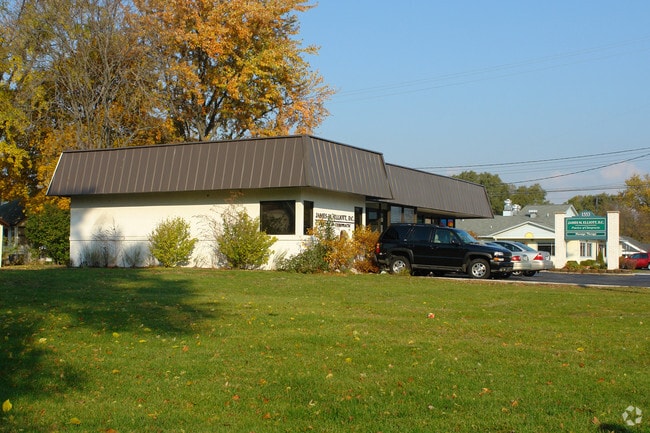
1553 Alpine Ave Nw
West Michigan
Incl Harrisons Third Add
Grand Rapids-Wyoming, MI
411314429017 LOTS 1 THRU 7 INCL * HARRISON'S THIRD ADDITION SPLIT/COMBINED ON 11/30/2021 FROM 41-13-14-429-016,
41-13-14-429-017
Kent
Dentalbldg
Michigan
2024
1-7
2025
0.60 AC
000700
Central Grand Rapids
2,088 SF
DEMOGRAPHICS near 1553 Alpine Ave Nw
1 Mile
3 Mile
5 Mile
2024 Total Population
12,098
95,664
212,423
2029 Population
12,004
96,012
213,050
Pop Growth 2024-2029
(0.78%)
+ 0.36%
+ 0.30%
Average Age
35
37
37
2024 Total Households
4,717
42,338
85,770
HH Growth 2024-2029
(0.78%)
+ 0.49%
+ 0.39%
Median Household Inc
$51,436
$59,165
$61,910
Avg Household Size
2.50
2.20
2.40
2024 Avg HH Vehicles
2.00
2.00
2.00
Median Home Value
$163,131
$201,090
$210,938
Median Year Built
1946
1953
1956
Nearby Places
Map Layers
Map Styles
 Street
 Aerial
- Restaurants
- Banks
- Shops
- Fitness
- Groceries
PUBLIC TRANSPORTATION
COMMUTER RAIL
DRIVE
WALK
Distance
6 min
3.3 mi
AIRPORT
Gerald R Ford International
DRIVE
WALK
Distance
Gerald R Ford International
26 min
16.7 mi
Nearby Properties
Address
Land Use
TOTAL SIZE
Lot Size
Zoning
Address
Land Use
TOTAL SIZE
Lot Size
Zoning
226,925 SF
1.32 AC
TN-CC
Address
Land Use
TOTAL SIZE
Lot Size
Zoning
557,931 SF
2.12 AC
TN-CC
Address
Land Use
TOTAL SIZE
Lot Size
Zoning
537,080 SF
46.61 AC
RPUD - 2
Address
Land Use
TOTAL SIZE
Lot Size
Zoning
546,366 SF
28.40 AC
MH
Address
Land Use
TOTAL SIZE
Lot Size
Zoning
265,905 SF
1.99 AC
TN-CC
Address
Land Use
TOTAL SIZE
Lot Size
Zoning
768,153 SF
3.20 AC
TN-CC
Address
Land Use
TOTAL SIZE
Lot Size
Zoning
347,500 SF
1.51 AC
TN-CC
Address
Land Use
TOTAL SIZE
Lot Size
Zoning
491,288 SF
2.79 AC
SD-PRD
Address
Land Use
TOTAL SIZE
Lot Size
Zoning
451,792 SF
32.60 AC
ARM - MULT
Address
Land Use
TOTAL SIZE
Lot Size
Zoning
138,122 SF
1.01 AC
TN-CC
Address
Land Use
TOTAL SIZE
Lot Size
Zoning
455,639 SF
42.06 AC
MH
Address
Land Use
TOTAL SIZE
Lot Size
Zoning
Address
Land Use
TOTAL SIZE
Lot Size
Zoning
281,488 SF
1.20 AC
TN-CC
Address
Land Use
TOTAL SIZE
Lot Size
Zoning
145,306 SF
0.75 AC
TN-CC
Address
Land Use
TOTAL SIZE
Lot Size
Zoning
164,591 SF
1.28 AC
TN-CC
Address
Land Use
TOTAL SIZE
Lot Size
Zoning
340,744 SF
69.50 AC
RPUD - 2
Address
Land Use
TOTAL SIZE
Lot Size
Zoning
Address
Land Use
TOTAL SIZE
Lot Size
Zoning
201,100 SF
0.90 AC
TN-CC
Address
Land Use
TOTAL SIZE
Lot Size
Zoning
337,324 SF
10.15 AC
C-3
Address
Land Use
TOTAL SIZE
Lot Size
Zoning
94,556 SF
1.03 AC
TN-TCC
Address
Land Use
TOTAL SIZE
Lot Size
Zoning
Address
Land Use
TOTAL SIZE
Lot Size
Zoning
343,973 SF
29.15 AC
MON-LDR
Address
Land Use
TOTAL SIZE
Lot Size
Zoning
88,327 SF
2.74 AC
TN-CC
Address
Land Use
TOTAL SIZE
Lot Size
Zoning
366,447 SF
2.71 AC
TN-CC
Address
Land Use
TOTAL SIZE
Lot Size
Zoning
18.65 AC
MCN-MDR
Address
Land Use
TOTAL SIZE
Lot Size
Zoning
363,503 SF
2.20 AC
TN-CC
Address
Land Use
TOTAL SIZE
Lot Size
Zoning
68,560 SF
2.76 AC
TN-TCC
Address
Land Use
TOTAL SIZE
Lot Size
Zoning
254,941 SF
0.79 AC
TN-CC
Address
Land Use
TOTAL SIZE
Lot Size
Zoning
109,482 SF
1.35 AC
SD-PRD
Address
Land Use
TOTAL SIZE
Lot Size
Zoning
310,790 SF
0.66 AC
TN-CC
The World's #1 Commercial Real Estate Marketplace
Connect with us
© 2026 CoStar Group
The information above has been obtained from sources believed reliable. While we do not doubt its accuracy we have not verified it and make no guarantee, warranty or representation about it. It is your responsibility to independently confirm its accuracy and completeness. Any projections, opinions, assumptions, or estimates used are for example only and do not represent the current or future performance of the property. The value of this transaction to you depends on tax and other factors which should be evaluated by your tax, financial, and legal advisors. You and your advisors should conduct a careful, independent investigation of the property to determine to your satisfaction the suitability of the property for your needs.