Property Record
15552 Us Highway 301, Dade City, FL 33523

NEARBY LISTINGS FOR SALE OR LEASE
Property Detail
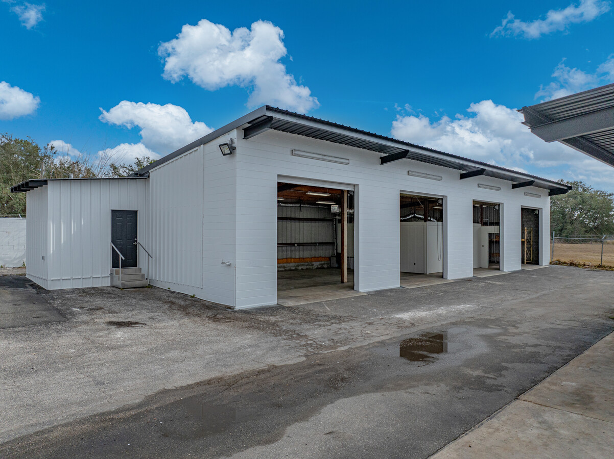
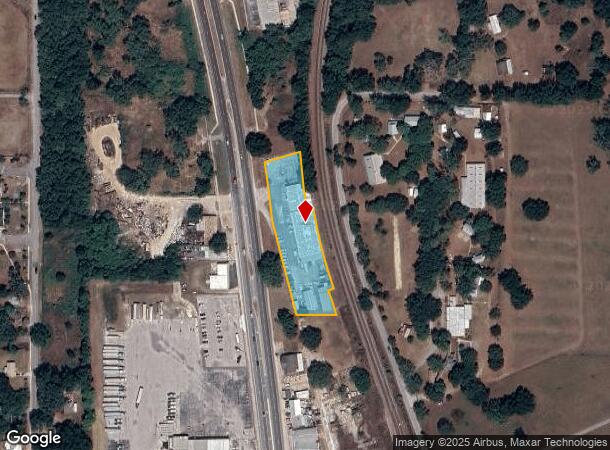
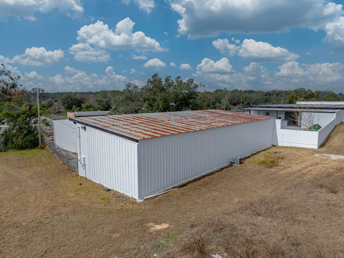
15552 Us Highway 301
22-24-21-0000-03200-0000
Acreage
Warehouse
POR OF SW1/4 OF NE1/4 LYING EAST OF OLD SR 23 & WEST OF ACL RR R/W EXC SOUTH 600FT & EXC NORTH272.89FT THEREOF &EXC FOLL DESC PCL:COM ON ELY R/W LN OF US HWY 301 72.89FT SOUTH OF NORTH BDY SW1/4 OF NE1/4 TH PARALLEL WITH SAID LN N89DEG 4553E149.96FT
X
Pasco
12101C0115F
Florida
2024
2 AC
2024
Pasco County
032500
Tampa/St Petersburg
20,558 SF
Tampa-St. Petersburg-Clearwater, FL
DEMOGRAPHICS near 15552 Us Highway 301
1 Mile
3 Mile
5 Mile
2024 Total Population
4,124
16,950
29,153
2029 Population
4,935
20,466
34,914
Pop Growth 2024-2029
+ 19.67%
+ 20.74%
+ 19.76%
Average Age
36
39
41
2024 Total Households
1,313
6,009
10,683
HH Growth 2024-2029
+ 19.80%
+ 20.92%
+ 20.05%
Median Household Inc
$56,592
$54,485
$58,358
Avg Household Size
2.90
2.70
2.50
2024 Avg HH Vehicles
2.00
2.00
2.00
Median Home Value
$134,893
$192,452
$227,075
Median Year Built
1969
1979
1984
Nearby Places
- Restaurants
- Banks
- Shops
- Fitness
- Groceries
SALE & LEASE HISTORY
LISTING DATE
SALE/LEASE

Feb 14, 2025
For Lease
Nearby Properties
Address
Land Use
TOTAL SIZE
Lot Size
Zoning
Address
Land Use
TOTAL SIZE
Lot Size
Zoning
191,025 SF
27.54 AC
RIO
Address
Land Use
TOTAL SIZE
Lot Size
Zoning
119,784 SF
7.79 AC
RIO
Address
Land Use
TOTAL SIZE
Lot Size
Zoning
118,676 SF
80.02 AC
RIO
Address
Land Use
TOTAL SIZE
Lot Size
Zoning
98,666 SF
19.80 AC
RIO
Address
Land Use
TOTAL SIZE
Lot Size
Zoning
320,071 SF
23.74 AC
PDEC
Address
Land Use
TOTAL SIZE
Lot Size
Zoning
76,418 SF
2.78 AC
RIO
Address
Land Use
TOTAL SIZE
Lot Size
Zoning
84,706 SF
13.65 AC
RIO
Address
Land Use
TOTAL SIZE
Lot Size
Zoning
82,689 SF
19.18 AC
RG1
Address
Land Use
TOTAL SIZE
Lot Size
Zoning
111,677 SF
10.40 AC
CG
Address
Land Use
TOTAL SIZE
Lot Size
Zoning
33,580 SF
6.09 AC
RIO
Address
Land Use
TOTAL SIZE
Lot Size
Zoning
86,138 SF
6.62 AC
CG
Address
Land Use
TOTAL SIZE
Lot Size
Zoning
88,358 SF
36.68 AC
OUA
Address
Land Use
TOTAL SIZE
Lot Size
Zoning
70,032 SF
12.80 AC
MPUD
Address
Land Use
TOTAL SIZE
Lot Size
Zoning
64,520 SF
11.65 AC
I2
Address
Land Use
TOTAL SIZE
Lot Size
Zoning
36,518 SF
2.77 AC
CG
Address
Land Use
TOTAL SIZE
Lot Size
Zoning
95,673 SF
7.51 AC
PDH2
Address
Land Use
TOTAL SIZE
Lot Size
Zoning
65,354 SF
15 AC
RIO
Address
Land Use
TOTAL SIZE
Lot Size
Zoning
131,580 SF
3.84 AC
PDEC
Address
Land Use
TOTAL SIZE
Lot Size
Zoning
44,210 SF
7.10 AC
C2
Address
Land Use
TOTAL SIZE
Lot Size
Zoning
35,904 SF
5.19 AC
RS1
Address
Land Use
TOTAL SIZE
Lot Size
Zoning
37,024 SF
5 AC
RIO
Address
Land Use
TOTAL SIZE
Lot Size
Zoning
112,952 SF
13.03 AC
MF1
Address
Land Use
TOTAL SIZE
Lot Size
Zoning
32,530 SF
33 AC
RIO
Address
Land Use
TOTAL SIZE
Lot Size
Zoning
130,200 SF
0.74 AC
CBD
Address
Land Use
TOTAL SIZE
Lot Size
Zoning
41,400 SF
4.91 AC
PDEC
Address
Land Use
TOTAL SIZE
Lot Size
Zoning
132,517 SF
10.26 AC
I2
Address
Land Use
TOTAL SIZE
Lot Size
Zoning
20,070 SF
1.62 AC
CBD
Address
Land Use
TOTAL SIZE
Lot Size
Zoning
32,912 SF
1.98 AC
C2
Address
Land Use
TOTAL SIZE
Lot Size
Zoning
64,226 SF
23 AC
RG1
Address
Land Use
TOTAL SIZE
Lot Size
Zoning
114,408 SF
3.78 AC
PDEC
The World's #1 Commercial Real Estate Marketplace
Connect with us
© 2025 CoStar Group
The information above has been obtained from sources believed reliable. While we do not doubt its accuracy we have not verified it and make no guarantee, warranty or representation about it. It is your responsibility to independently confirm its accuracy and completeness. Any projections, opinions, assumptions, or estimates used are for example only and do not represent the current or future performance of the property. The value of this transaction to you depends on tax and other factors which should be evaluated by your tax, financial, and legal advisors. You and your advisors should conduct a careful, independent investigation of the property to determine to your satisfaction the suitability of the property for your needs.