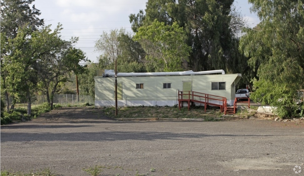
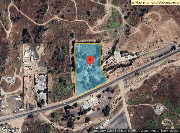
Property Record
15559 Sierra Hwy, Santa Clarita, CA 91390
NEARBY LISTINGS FOR SALE OR LEASE
Property Detail
15559 Sierra Hwy
2853-002-002
LOT COM E 100 FT FROM NW COR OF LOT 2 IN SEC 1 T 4N R 15W TH E TO A PT W 974.68 FT FROM INTERSECTION OF NW LINE OF SIERRA HWY WITH N LINE OF SD SEC TH S 1 1115 W 246.16 FT TH S 21 3525 E LOT/SEC 1 BLK/DIV/TWN 4N REG/RNG15
Commercialnec
Los Angeles
AE
California
06037C0835G
2
2024
3.56 AC
2024
Santa Clarita Valley
920049
Los Angeles
912 SF
Los Angeles-Long Beach-Glendale, CA
DEMOGRAPHICS near 15559 Sierra Hwy
1 Mile
3 Mile
5 Mile
2024 Total Population
351
15,546
65,304
2029 Population
337
14,863
62,842
Pop Growth 2024-2029
(3.99%)
(4.39%)
(3.77%)
Average Age
42
40
38
2024 Total Households
107
4,813
20,305
HH Growth 2024-2029
(3.74%)
(4.63%)
(4.10%)
Median Household Inc
$91,666
$117,615
$102,213
Avg Household Size
3.10
3.20
3.10
2024 Avg HH Vehicles
3.00
3.00
2.00
Median Home Value
$753,968
$717,837
$686,100
Median Year Built
1979
1984
1987
Nearby Places
- Restaurants
- Banks
- Shops
- Fitness
- Groceries
PUBLIC TRANSPORTATION
COMMUTER RAIL
Via Princessa (Antelope Valley Line - Southern California Regional Rail Authority (Metrolink))
DRIVE
WALK
Distance
Via Princessa (Antelope Valley Line - Southern California Regional Rail Authority (Metrolink))
9 min
5.9 mi
Santa Clarita (Antelope Valley Line - Southern California Regional Rail Authority (Metrolink))
DRIVE
WALK
Distance
Santa Clarita (Antelope Valley Line - Southern California Regional Rail Authority (Metrolink))
14 min
8.9 mi
AIRPORT
Bob Hope
DRIVE
WALK
Distance
Bob Hope
33 min
25.7 mi
Freight Ports
Port of Long Beach
DRIVE
WALK
Distance
Port of Long Beach
76 min
62.1 mi
Nearby Properties
Address
Land Use
TOTAL SIZE
Lot Size
Zoning
Address
Land Use
TOTAL SIZE
Lot Size
Zoning
272,382 SF
35.44 AC
SCUR5
Address
Land Use
TOTAL SIZE
Lot Size
Zoning
38,308 SF
2.04 AC
SCCC
Address
Land Use
TOTAL SIZE
Lot Size
Zoning
96,666 SF
9.19 AC
SCBP
Address
Land Use
TOTAL SIZE
Lot Size
Zoning
18,900 SF
4.67 AC
LCM1*
Address
Land Use
TOTAL SIZE
Lot Size
Zoning
50,639 SF
3.50 AC
SCUR2
Address
Land Use
TOTAL SIZE
Lot Size
Zoning
43,605 SF
2.36 AC
SCUR2
Address
Land Use
TOTAL SIZE
Lot Size
Zoning
45,016 SF
2.56 AC
SCCC
Address
Land Use
TOTAL SIZE
Lot Size
Zoning
38,362 SF
2.07 AC
SCUR2
Address
Land Use
TOTAL SIZE
Lot Size
Zoning
840 SF
31.53 AC
LCC3-A11*
Address
Land Use
TOTAL SIZE
Lot Size
Zoning
148.76 AC
LCC3-A11-R
Address
Land Use
TOTAL SIZE
Lot Size
Zoning
24,966 SF
1.16 AC
SCCC
Address
Land Use
TOTAL SIZE
Lot Size
Zoning
24,700 SF
1.81 AC
SCUR3
Address
Land Use
TOTAL SIZE
Lot Size
Zoning
24,700 SF
1.29 AC
SCUR3
Address
Land Use
TOTAL SIZE
Lot Size
Zoning
38,308 SF
0.85 AC
SCCC
Address
Land Use
TOTAL SIZE
Lot Size
Zoning
6,740 SF
0.44 AC
SCCC
Address
Land Use
TOTAL SIZE
Lot Size
Zoning
4,609 SF
0.44 AC
SCCC
Address
Land Use
TOTAL SIZE
Lot Size
Zoning
38,308 SF
0.39 AC
SCCC
Address
Land Use
TOTAL SIZE
Lot Size
Zoning
18,525 SF
1.69 AC
SCUR3
Address
Land Use
TOTAL SIZE
Lot Size
Zoning
976 SF
11.55 AC
LCM11/2*
Address
Land Use
TOTAL SIZE
Lot Size
Zoning
3,780 SF
6.04 AC
SCCC
Address
Land Use
TOTAL SIZE
Lot Size
Zoning
19.86 AC
LCC3-A11*
Address
Land Use
TOTAL SIZE
Lot Size
Zoning
3,776 SF
0.58 AC
SCCC
Address
Land Use
TOTAL SIZE
Lot Size
Zoning
1,800 SF
0.56 AC
SCCC
Address
Land Use
TOTAL SIZE
Lot Size
Zoning
6,283 SF
0.62 AC
SCCC
Address
Land Use
TOTAL SIZE
Lot Size
Zoning
1,200 SF
7.45 AC
LCM1*
Address
Land Use
TOTAL SIZE
Lot Size
Zoning
11,424 SF
4.02 AC
LCM1*
Address
Land Use
TOTAL SIZE
Lot Size
Zoning
669 SF
2.52 AC
SCCC
Address
Land Use
TOTAL SIZE
Lot Size
Zoning
43,967 SF
40.97 AC
LCM11/2*
Address
Land Use
TOTAL SIZE
Lot Size
Zoning
12,350 SF
0.60 AC
SCUR3
Address
Land Use
TOTAL SIZE
Lot Size
Zoning
3,314 SF
0.87 AC
LCC3*
The World's #1 Commercial Real Estate Marketplace
Connect with us
© 2025 CoStar Group
The information above has been obtained from sources believed reliable. While we do not doubt its accuracy we have not verified it and make no guarantee, warranty or representation about it. It is your responsibility to independently confirm its accuracy and completeness. Any projections, opinions, assumptions, or estimates used are for example only and do not represent the current or future performance of the property. The value of this transaction to you depends on tax and other factors which should be evaluated by your tax, financial, and legal advisors. You and your advisors should conduct a careful, independent investigation of the property to determine to your satisfaction the suitability of the property for your needs.