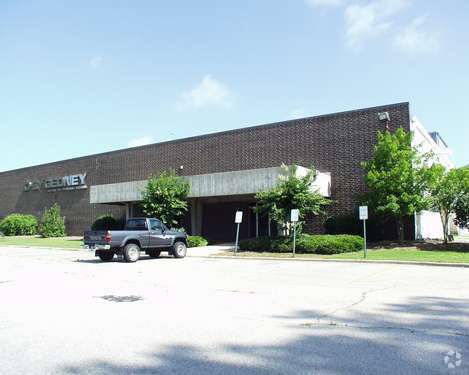
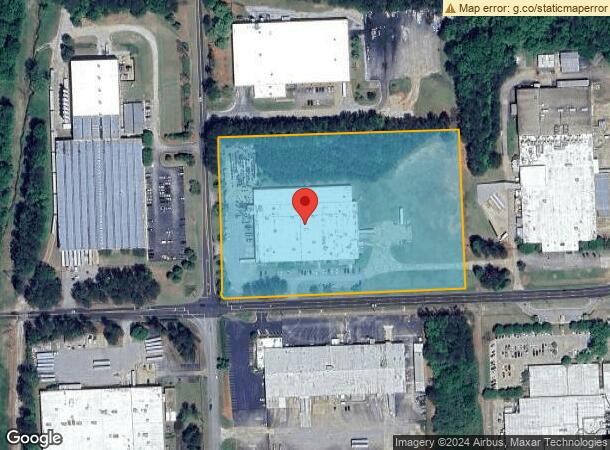
Property Record
1570 Lukken Industrial Dr W, Lagrange, GA 30240
NEARBY LISTINGS FOR SALE OR LEASE
Property Detail
1570 Lukken Industrial Dr W
LaGrange, GA
Ashton Place
060-2D-004-009
1570 W LUKKEN INDUSTRIAL DR/PT TR 2 PB 16
Warehouse
Troup
X
Georgia
13285C0143E
146
2023
9.92 AC
2023
Troup County
960901
Columbus GA
82,179 SF
DEMOGRAPHICS near 1570 Lukken Industrial Dr W
1 Mile
3 Mile
5 Mile
2024 Total Population
2,070
17,710
40,370
2029 Population
2,133
18,139
41,004
Pop Growth 2024-2029
+ 3.04%
+ 2.42%
+ 1.57%
Average Age
35
38
39
2024 Total Households
759
6,883
15,498
HH Growth 2024-2029
+ 3.03%
+ 2.50%
+ 1.61%
Median Household Inc
$40,357
$42,790
$46,982
Avg Household Size
2.60
2.40
2.50
2024 Avg HH Vehicles
2.00
2.00
2.00
Median Home Value
$87,754
$138,382
$167,485
Median Year Built
1954
1972
1981
Nearby Places
- Restaurants
- Banks
- Shops
- Fitness
- Groceries
Nearby Properties
Address
Land Use
TOTAL SIZE
Lot Size
Zoning
Address
Land Use
TOTAL SIZE
Lot Size
Zoning
29978
44.39 AC
023
Address
Land Use
TOTAL SIZE
Lot Size
Zoning
561429
72.64 AC
025
Address
Land Use
TOTAL SIZE
Lot Size
Zoning
525250
45.33 AC
025
Address
Land Use
TOTAL SIZE
Lot Size
Zoning
162803
3.71 AC
16- CP-GI
Address
Land Use
TOTAL SIZE
Lot Size
Zoning
109533
1.80 AC
022
Address
Land Use
TOTAL SIZE
Lot Size
Zoning
174899
7.52 AC
036
Address
Land Use
TOTAL SIZE
Lot Size
Zoning
211264
57.40 AC
039
Address
Land Use
TOTAL SIZE
Lot Size
Zoning
92907
41.61 AC
025
Address
Land Use
TOTAL SIZE
Lot Size
Zoning
4200
2.98 AC
022
Address
Land Use
TOTAL SIZE
Lot Size
Zoning
21376
30.05 AC
023
Address
Land Use
TOTAL SIZE
Lot Size
Zoning
29520
1.92 AC
039
Address
Land Use
TOTAL SIZE
Lot Size
Zoning
29978
1 AC
023
Address
Land Use
TOTAL SIZE
Lot Size
Zoning
484700
54.09 AC
025
Address
Land Use
TOTAL SIZE
Lot Size
Zoning
89395
28.47 AC
036
Address
Land Use
TOTAL SIZE
Lot Size
Zoning
334378
267.59 AC
16- CP-GI
Address
Land Use
TOTAL SIZE
Lot Size
Zoning
9290
11.58 AC
023
Address
Land Use
TOTAL SIZE
Lot Size
Zoning
41020
7.10 AC
025
Address
Land Use
TOTAL SIZE
Lot Size
Zoning
27080
27.40 AC
025
Address
Land Use
TOTAL SIZE
Lot Size
Zoning
64432
81.09 AC
025
Address
Land Use
TOTAL SIZE
Lot Size
Zoning
2366
8.70 AC
039
Address
Land Use
TOTAL SIZE
Lot Size
Zoning
14232
2.59 AC
023
Address
Land Use
TOTAL SIZE
Lot Size
Zoning
2334
62.01 AC
023
Address
Land Use
TOTAL SIZE
Lot Size
Zoning
57971
7.98 AC
036
Address
Land Use
TOTAL SIZE
Lot Size
Zoning
97903
4.50 AC
025
Address
Land Use
TOTAL SIZE
Lot Size
Zoning
133950
1.94 AC
022
Address
Land Use
TOTAL SIZE
Lot Size
Zoning
91254
4.94 AC
021
Address
Land Use
TOTAL SIZE
Lot Size
Zoning
1156
13.43 AC
039
Address
Land Use
TOTAL SIZE
Lot Size
Zoning
58322
1.80 AC
022
Address
Land Use
TOTAL SIZE
Lot Size
Zoning
12208
26.56 AC
025
Address
Land Use
TOTAL SIZE
Lot Size
Zoning
2000
11.53 AC
036
Start a new search to find other properties for sale or lease
Connect with us
© 2024 CoStar Group
The information above has been obtained from sources believed reliable. While we do not doubt its accuracy we have not verified it and make no guarantee, warranty or representation about it. It is your responsibility to independently confirm its accuracy and completeness. Any projections, opinions, assumptions, or estimates used are for example only and do not represent the current or future performance of the property. The value of this transaction to you depends on tax and other factors which should be evaluated by your tax, financial, and legal advisors. You and your advisors should conduct a careful, independent investigation of the property to determine to your satisfaction the suitability of the property for your needs.