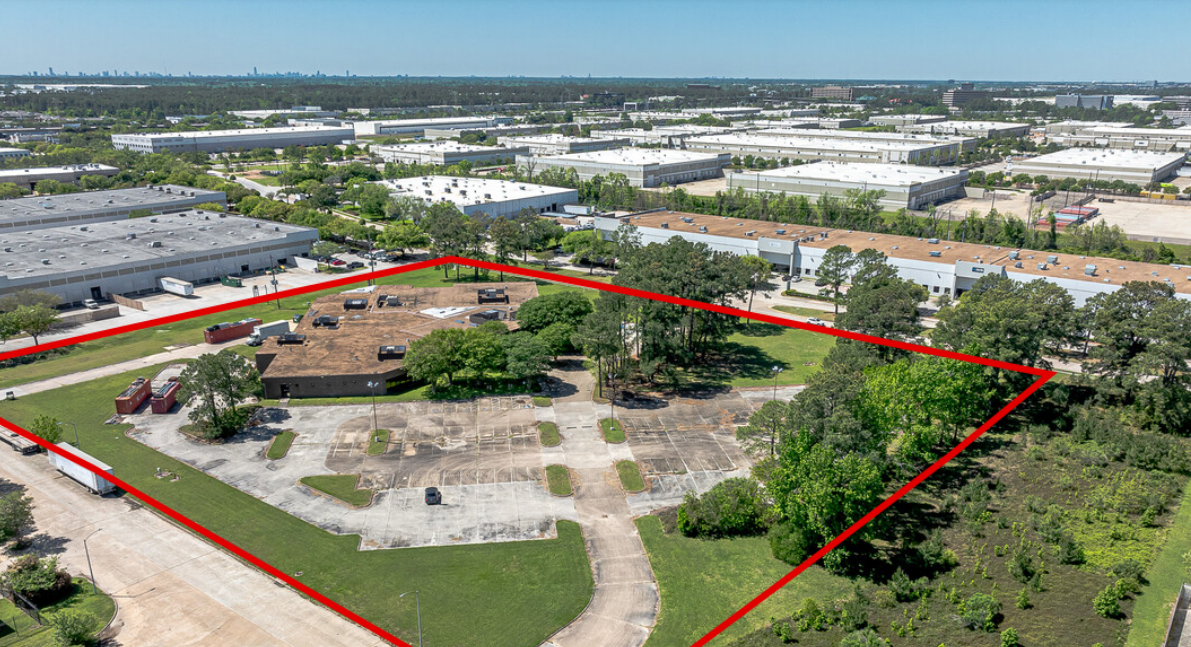
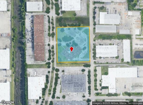
Property Record
15700 Vickery Dr, Houston, TX 77032
NEARBY LISTINGS FOR SALE OR LEASE
Property Detail
15700 Vickery Dr
1140270040002
World Houston Sec 1
Officebuilding
RES I BLK 4 WORLD HOUSTON SEC 1
X
Harris
48201C0480M
Texas
2023
5.48 AC
2023
North Hardy Toll Road
241503
Houston
38,791 SF
Houston-The Woodlands-Sugar Land, TX
DEMOGRAPHICS near 15700 Vickery Dr
1 Mile
3 Mile
5 Mile
2024 Total Population
5,682
41,986
149,401
2029 Population
5,859
42,541
152,267
Pop Growth 2024-2029
+ 3.12%
+ 1.32%
+ 1.92%
Average Age
33
34
34
2024 Total Households
1,709
12,881
47,553
HH Growth 2024-2029
+ 3.04%
+ 1.16%
+ 1.95%
Median Household Inc
$33,343
$53,680
$49,640
Avg Household Size
2.80
3.10
3.10
2024 Avg HH Vehicles
1.00
2.00
2.00
Median Home Value
$137,359
$165,894
$159,963
Median Year Built
1998
1986
1987
Nearby Places
- Restaurants
- Banks
- Shops
- Fitness
- Groceries
PUBLIC TRANSPORTATION
AIRPORT
George Bush Intcntl/Houston
DRIVE
WALK
Distance
George Bush Intcntl/Houston
6 min
3.8 mi
William P Hobby
DRIVE
WALK
Distance
William P Hobby
43 min
27.0 mi
Freight Ports
Port of Houston
DRIVE
WALK
Distance
Port of Houston
32 min
20.6 mi
SALE & LEASE HISTORY
LISTING DATE
SALE/LEASE

Mar 22, 2024
For Sale
Jun 06, 2019
For Sale
Jul 22, 2024
For Sale
Jan 09, 2020
For Lease
Nearby Properties
Address
Land Use
TOTAL SIZE
Lot Size
Zoning
Address
Land Use
TOTAL SIZE
Lot Size
Zoning
1,845,724 SF
69.99 AC
Address
Land Use
TOTAL SIZE
Lot Size
Zoning
1,767,053 SF
88.85 AC
Address
Land Use
TOTAL SIZE
Lot Size
Zoning
621,700 SF
67.56 AC
Address
Land Use
TOTAL SIZE
Lot Size
Zoning
785,390 SF
66.02 AC
Address
Land Use
TOTAL SIZE
Lot Size
Zoning
Address
Land Use
TOTAL SIZE
Lot Size
Zoning
541,440 SF
76.97 AC
Address
Land Use
TOTAL SIZE
Lot Size
Zoning
514,500 SF
40.84 AC
Address
Land Use
TOTAL SIZE
Lot Size
Zoning
523,480 SF
29.22 AC
Address
Land Use
TOTAL SIZE
Lot Size
Zoning
241,625 SF
11.10 AC
Address
Land Use
TOTAL SIZE
Lot Size
Zoning
321,604 SF
16.68 AC
Address
Land Use
TOTAL SIZE
Lot Size
Zoning
431,400 SF
30.88 AC
Address
Land Use
TOTAL SIZE
Lot Size
Zoning
379,570 SF
30.12 AC
Address
Land Use
TOTAL SIZE
Lot Size
Zoning
448,760 SF
8.46 AC
Address
Land Use
TOTAL SIZE
Lot Size
Zoning
338,700 SF
22.99 AC
Address
Land Use
TOTAL SIZE
Lot Size
Zoning
368,632 SF
20.06 AC
Address
Land Use
TOTAL SIZE
Lot Size
Zoning
361,919 SF
23.59 AC
Address
Land Use
TOTAL SIZE
Lot Size
Zoning
259,500 SF
12.28 AC
Address
Land Use
TOTAL SIZE
Lot Size
Zoning
207,720 SF
12.33 AC
Address
Land Use
TOTAL SIZE
Lot Size
Zoning
276,464 SF
18.79 AC
Address
Land Use
TOTAL SIZE
Lot Size
Zoning
90,033 SF
46.96 AC
Address
Land Use
TOTAL SIZE
Lot Size
Zoning
227,400 SF
19.37 AC
Address
Land Use
TOTAL SIZE
Lot Size
Zoning
264,300 SF
15.89 AC
Address
Land Use
TOTAL SIZE
Lot Size
Zoning
113,604 SF
10.70 AC
Address
Land Use
TOTAL SIZE
Lot Size
Zoning
170,407 SF
26.31 AC
Address
Land Use
TOTAL SIZE
Lot Size
Zoning
281,252 SF
8 AC
Address
Land Use
TOTAL SIZE
Lot Size
Zoning
738,939 SF
88.85 AC
Address
Land Use
TOTAL SIZE
Lot Size
Zoning
215,879 SF
7.30 AC
Address
Land Use
TOTAL SIZE
Lot Size
Zoning
181,720 SF
15.28 AC
Address
Land Use
TOTAL SIZE
Lot Size
Zoning
182,030 SF
15.12 AC
Address
Land Use
TOTAL SIZE
Lot Size
Zoning
314,294 SF
29.50 AC
The World's #1 Commercial Real Estate Marketplace
Connect with us
© 2025 CoStar Group
The information above has been obtained from sources believed reliable. While we do not doubt its accuracy we have not verified it and make no guarantee, warranty or representation about it. It is your responsibility to independently confirm its accuracy and completeness. Any projections, opinions, assumptions, or estimates used are for example only and do not represent the current or future performance of the property. The value of this transaction to you depends on tax and other factors which should be evaluated by your tax, financial, and legal advisors. You and your advisors should conduct a careful, independent investigation of the property to determine to your satisfaction the suitability of the property for your needs.