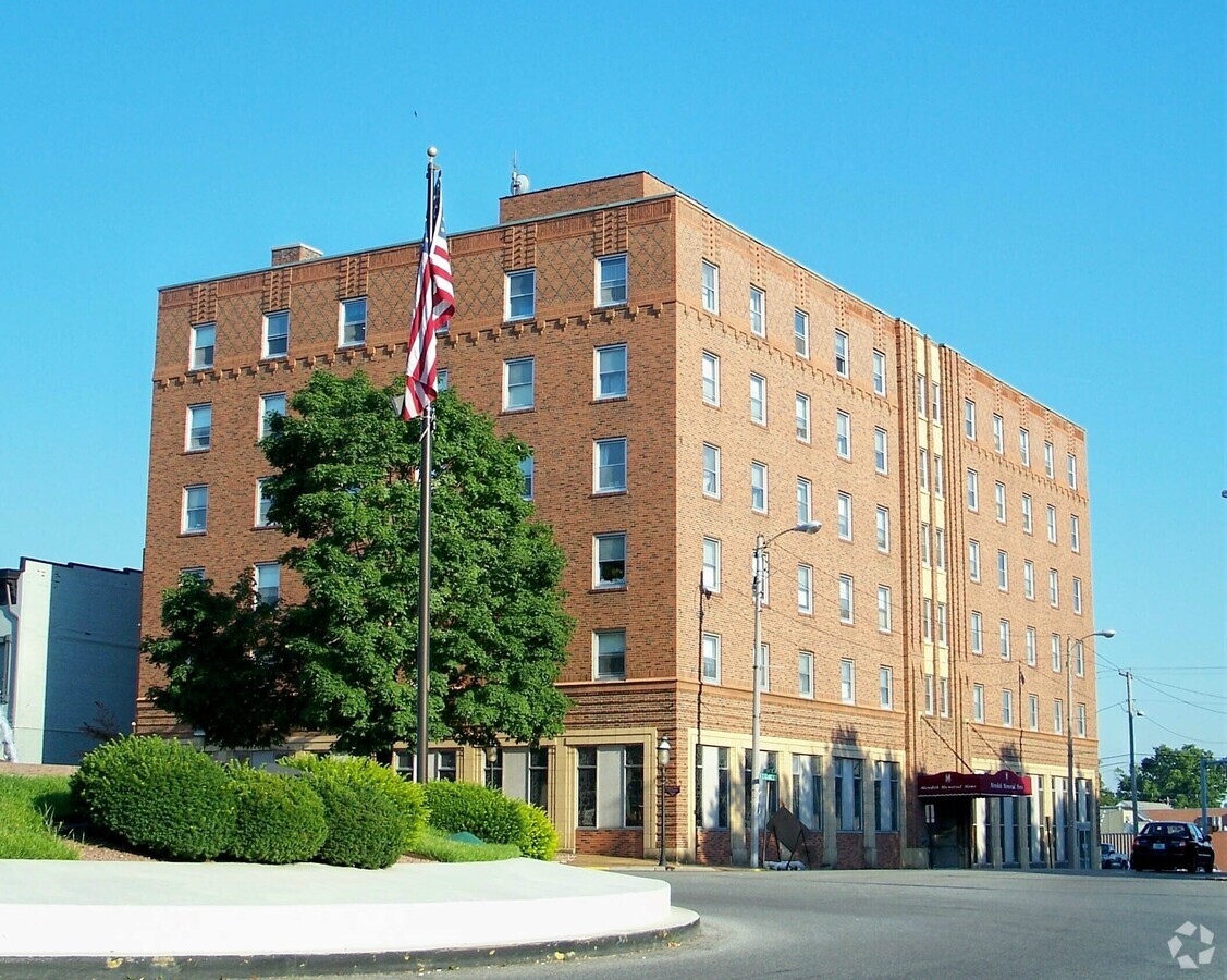
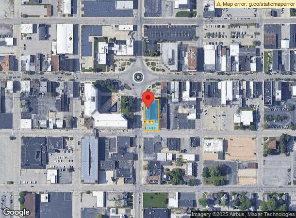
Property Record
16 S Illinois St, Belleville, IL 62220
NEARBY LISTINGS FOR SALE OR LEASE
-
-
View all Belleville listings for sale on LoopNet.com
Property Detail
16 S Illinois St
St. Louis
Belleville
St. Louis, MO-IL
BELLEVILLE ORIGINALTOWN LOT/SEC-43-BLK/RG-A LOTS 15A 15C 15D 43A & 43B A02649116
08-21.0-445-040
St. Clair
Specialpurpose
Illinois
2023
15a
2023
0.38 AC
501700
Belleville
10,679 SF
DEMOGRAPHICS near 16 S Illinois St
1 Mile
3 Mile
5 Mile
2024 Total Population
10,600
47,995
86,482
2029 Population
10,443
46,527
83,651
Pop Growth 2024-2029
(1.48%)
(3.06%)
(3.27%)
Average Age
40
41
41
2024 Total Households
4,327
20,559
36,498
HH Growth 2024-2029
(1.29%)
(3.03%)
(3.27%)
Median Household Inc
$61,291
$65,716
$73,192
Avg Household Size
2.10
2.20
2.30
2024 Avg HH Vehicles
2.00
2.00
2.00
Median Home Value
$99,767
$129,584
$162,854
Median Year Built
1947
1965
1975
Nearby Places
- Restaurants
- Banks
- Shops
- Fitness
- Groceries
PUBLIC TRANSPORTATION
COMMUTER RAIL
Belleville (Lambert Airport Shiloh-Scott - St. Louis MetroLink (MetroLink))
DRIVE
WALK
Distance
Belleville (Lambert Airport Shiloh-Scott - St. Louis MetroLink (MetroLink))
3 min
19 min
1.0 mi
Swansea (Lambert Airport Shiloh-Scott - St. Louis MetroLink (MetroLink))
DRIVE
WALK
Distance
Swansea (Lambert Airport Shiloh-Scott - St. Louis MetroLink (MetroLink))
4 min
2.0 mi
AIRPORT
Scott AFB/Midamerica St Louis
DRIVE
WALK
Distance
Scott AFB/Midamerica St Louis
22 min
11.0 mi
St Louis Lambert International
DRIVE
WALK
Distance
St Louis Lambert International
41 min
28.8 mi
Freight Ports
Port Milwaukee
DRIVE
WALK
Distance
Port Milwaukee
420 min
368.4 mi
Nearby Properties
Address
Land Use
TOTAL SIZE
Lot Size
Zoning
Address
Land Use
TOTAL SIZE
Lot Size
Zoning
3,388 SF
22.25 AC
Address
Land Use
TOTAL SIZE
Lot Size
Zoning
20,522 SF
6.42 AC
Address
Land Use
TOTAL SIZE
Lot Size
Zoning
41,366 SF
12.07 AC
Address
Land Use
TOTAL SIZE
Lot Size
Zoning
18,734 SF
10.48 AC
Address
Land Use
TOTAL SIZE
Lot Size
Zoning
127,590 SF
10.53 AC
Address
Land Use
TOTAL SIZE
Lot Size
Zoning
104,230 SF
11.08 AC
Address
Land Use
TOTAL SIZE
Lot Size
Zoning
7.82 AC
Address
Land Use
TOTAL SIZE
Lot Size
Zoning
126,937 SF
11.98 AC
Address
Land Use
TOTAL SIZE
Lot Size
Zoning
Address
Land Use
TOTAL SIZE
Lot Size
Zoning
13,546 SF
11.19 AC
Address
Land Use
TOTAL SIZE
Lot Size
Zoning
86,482 SF
8 AC
Address
Land Use
TOTAL SIZE
Lot Size
Zoning
6,800 SF
4.33 AC
Address
Land Use
TOTAL SIZE
Lot Size
Zoning
155,488 SF
16.54 AC
Address
Land Use
TOTAL SIZE
Lot Size
Zoning
15,839 SF
5.96 AC
Address
Land Use
TOTAL SIZE
Lot Size
Zoning
26,233 SF
17.61 AC
Address
Land Use
TOTAL SIZE
Lot Size
Zoning
48,634 SF
5.86 AC
Address
Land Use
TOTAL SIZE
Lot Size
Zoning
88,468 SF
10.48 AC
Address
Land Use
TOTAL SIZE
Lot Size
Zoning
4.70 AC
Address
Land Use
TOTAL SIZE
Lot Size
Zoning
26.26 AC
C2
Address
Land Use
TOTAL SIZE
Lot Size
Zoning
4,818 SF
3.64 AC
Address
Land Use
TOTAL SIZE
Lot Size
Zoning
23,951 SF
0.89 AC
Address
Land Use
TOTAL SIZE
Lot Size
Zoning
4,400 SF
2.56 AC
Address
Land Use
TOTAL SIZE
Lot Size
Zoning
1,280 SF
4.50 AC
Address
Land Use
TOTAL SIZE
Lot Size
Zoning
8,208 SF
1.58 AC
Address
Land Use
TOTAL SIZE
Lot Size
Zoning
38,259 SF
7.80 AC
Address
Land Use
TOTAL SIZE
Lot Size
Zoning
12,010 SF
2.49 AC
Address
Land Use
TOTAL SIZE
Lot Size
Zoning
47,369 SF
4.17 AC
Address
Land Use
TOTAL SIZE
Lot Size
Zoning
12.99 AC
Address
Land Use
TOTAL SIZE
Lot Size
Zoning
36,445 SF
6.07 AC
Address
Land Use
TOTAL SIZE
Lot Size
Zoning
11,709 SF
1.42 AC
The World's #1 Commercial Real Estate Marketplace
Connect with us
© 2025 CoStar Group
The information above has been obtained from sources believed reliable. While we do not doubt its accuracy we have not verified it and make no guarantee, warranty or representation about it. It is your responsibility to independently confirm its accuracy and completeness. Any projections, opinions, assumptions, or estimates used are for example only and do not represent the current or future performance of the property. The value of this transaction to you depends on tax and other factors which should be evaluated by your tax, financial, and legal advisors. You and your advisors should conduct a careful, independent investigation of the property to determine to your satisfaction the suitability of the property for your needs.