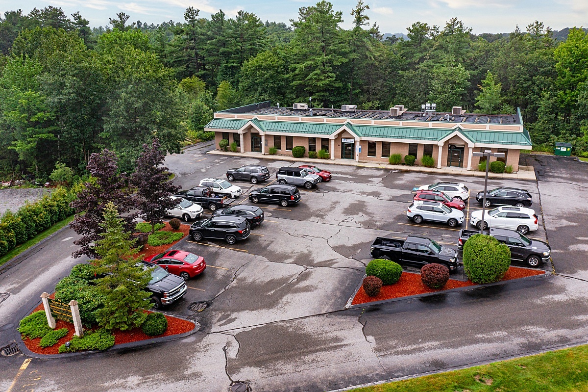
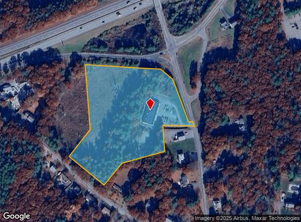
Property Record
16 Wyman Rd, Westminster, MA 01473

Current Lease Availabilities
NEARBY LISTINGS FOR SALE OR LEASE
Property Detail
16 Wyman Rd
WEST-7 19 I
Worcester
Commercialbuilding
Massachusetts
ARE
37
25027C0242E
6.91 AC
2025
Outlying Worcester
2025
Boston
708100
Worcester, MA-CT
7,920 SF
DEMOGRAPHICS near 16 Wyman Rd
1 Mile
3 Mile
5 Mile
2024 Total Population
1,532
8,350
32,158
2029 Population
1,541
8,359
32,075
Pop Growth 2024-2029
+ 0.59%
+ 0.11%
(0.26%)
Average Age
43
42
41
2024 Total Households
601
3,204
12,226
HH Growth 2024-2029
+ 0.50%
+ 0.06%
(0.29%)
Median Household Inc
$122,079
$106,844
$87,490
Avg Household Size
2.50
2.60
2.50
2024 Avg HH Vehicles
2.00
2.00
2.00
Median Home Value
$428,455
$355,021
$309,455
Median Year Built
1978
1973
1961
Nearby Places
- Restaurants
- Banks
- Shops
- Fitness
- Groceries
PUBLIC TRANSPORTATION
COMMUTER RAIL
Wachusett (Fitchburg Line - MBTA)
DRIVE
WALK
Distance
Wachusett (Fitchburg Line - MBTA)
7 min
2.7 mi
Fitchburg (Fitchburg/South Acton Line - Massachusetts Bay Transportation Authority Commuter Rail (Purple Line))
DRIVE
WALK
Distance
Fitchburg (Fitchburg/South Acton Line - Massachusetts Bay Transportation Authority Commuter Rail (Purple Line))
16 min
8.6 mi
AIRPORT
Worcester Regional
DRIVE
WALK
Distance
Worcester Regional
46 min
26.9 mi
Freight Ports
Port of Boston
DRIVE
WALK
Distance
Port of Boston
79 min
52.3 mi
Nearby Properties
Address
Land Use
TOTAL SIZE
Lot Size
Zoning
Address
Land Use
TOTAL SIZE
Lot Size
Zoning
276,822 SF
26.98 AC
I
Address
Land Use
TOTAL SIZE
Lot Size
Zoning
127.30 AC
AI
Address
Land Use
TOTAL SIZE
Lot Size
Zoning
87,326 SF
20.74 AC
Address
Land Use
TOTAL SIZE
Lot Size
Zoning
113,250 SF
34.55 AC
CR
Address
Land Use
TOTAL SIZE
Lot Size
Zoning
262,800 SF
32.80 AC
Address
Land Use
TOTAL SIZE
Lot Size
Zoning
74.90 AC
Address
Land Use
TOTAL SIZE
Lot Size
Zoning
164,545 SF
50.64 AC
Address
Land Use
TOTAL SIZE
Lot Size
Zoning
Address
Land Use
TOTAL SIZE
Lot Size
Zoning
56,475 SF
4.26 AC
I
Address
Land Use
TOTAL SIZE
Lot Size
Zoning
91,941 SF
10.55 AC
I
Address
Land Use
TOTAL SIZE
Lot Size
Zoning
36,419 SF
1.68 AC
Address
Land Use
TOTAL SIZE
Lot Size
Zoning
21,800 SF
16.48 AC
AI
Address
Land Use
TOTAL SIZE
Lot Size
Zoning
1,187.86 AC
Address
Land Use
TOTAL SIZE
Lot Size
Zoning
99,400 SF
8.58 AC
I
Address
Land Use
TOTAL SIZE
Lot Size
Zoning
4.74 AC
I
Address
Land Use
TOTAL SIZE
Lot Size
Zoning
45.86 AC
Address
Land Use
TOTAL SIZE
Lot Size
Zoning
83,408 SF
6.18 AC
I
Address
Land Use
TOTAL SIZE
Lot Size
Zoning
57.58 AC
Address
Land Use
TOTAL SIZE
Lot Size
Zoning
21,758 SF
15.01 AC
Address
Land Use
TOTAL SIZE
Lot Size
Zoning
793.98 AC
Address
Land Use
TOTAL SIZE
Lot Size
Zoning
Address
Land Use
TOTAL SIZE
Lot Size
Zoning
85,570 SF
5.98 AC
I
Address
Land Use
TOTAL SIZE
Lot Size
Zoning
101,226 SF
6.80 AC
I
Address
Land Use
TOTAL SIZE
Lot Size
Zoning
45.51 AC
Address
Land Use
TOTAL SIZE
Lot Size
Zoning
122,896 SF
17 AC
Address
Land Use
TOTAL SIZE
Lot Size
Zoning
152,152 SF
13.65 AC
AI
Address
Land Use
TOTAL SIZE
Lot Size
Zoning
30,100 SF
19.26 AC
Address
Land Use
TOTAL SIZE
Lot Size
Zoning
13.60 AC
Address
Land Use
TOTAL SIZE
Lot Size
Zoning
42,032 SF
5.63 AC
Address
Land Use
TOTAL SIZE
Lot Size
Zoning
63,440 SF
6.37 AC
I
The World's #1 Commercial Real Estate Marketplace
Connect with us
© 2025 CoStar Group
The information above has been obtained from sources believed reliable. While we do not doubt its accuracy we have not verified it and make no guarantee, warranty or representation about it. It is your responsibility to independently confirm its accuracy and completeness. Any projections, opinions, assumptions, or estimates used are for example only and do not represent the current or future performance of the property. The value of this transaction to you depends on tax and other factors which should be evaluated by your tax, financial, and legal advisors. You and your advisors should conduct a careful, independent investigation of the property to determine to your satisfaction the suitability of the property for your needs.