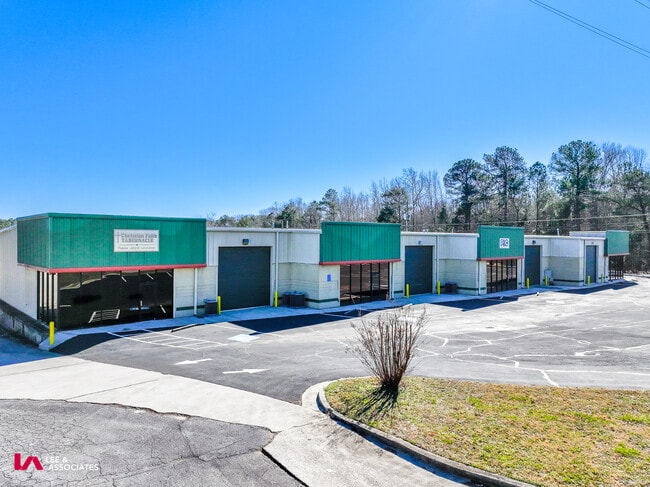
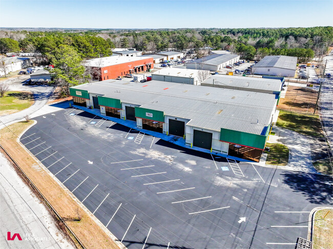
Property Record
1601 Lester Rd Nw, Conyers, GA 30012

Current Lease Availabilities
Property Detail
1601 Lester Rd Nw
041-0-01-023L
LESTER RD
Industrialgeneral
Rockdale
M1
Georgia
B and X Area of moderate flood hazard, usually the area between the limits of the 100-year and 500-year floods.
246
2025
1.14 AC
2025
Rockdale/Newton Cnty
060310
Atlanta
19,750 SF
Atlanta-Sandy Springs-Roswell, GA
NEARBY LISTINGS FOR SALE OR LEASE
DEMOGRAPHICS near 1601 Lester Rd Nw
1 mile
3 mile
5 mile
2025 Total Population
916
31,329
75,948
2030 Population
959
32,585
78,939
Pop Growth 2025-2030
+ 4.69%
+ 4.01%
+ 3.94%
Average Age
36
38
39
2025 Total Households
309
11,340
27,823
HH Growth 2025-2030
+ 4.85%
+ 4.09%
+ 3.95%
Median Household Inc
$90,322
$71,953
$68,106
Avg Household Size
2.70
2.60
2.60
2025 Avg HH Vehicles
2.00
2.00
2.00
Median Home Value
$327,907
$266,615
$273,984
Median Year Built
2002
1985
1991
Nearby Places
Map Layers
Map Styles
 Street
 Aerial
Layers
 Traffic
 Biking
Places
Listings with unknown addresses are not visible on the map
- Restaurants
- Banks
- Shops
- Fitness
- Groceries
PUBLIC TRANSPORTATION
AIRPORT
Hartsfield - Jackson Atlanta International
Drive
Walk
Distance
Hartsfield - Jackson Atlanta International
36 min
25.8 mi
Freight Ports
Georgia Ports - Savannah
Drive
Walk
Distance
Georgia Ports - Savannah
281 min
243.7 mi
Nearby Properties
Address
Land Use
TOTAL SIZE
Lot Size
Zoning
Address
Land Use
TOTAL SIZE
Lot Size
Zoning
2,782 SF
29.51 AC
R3/C
Address
Land Use
TOTAL SIZE
Lot Size
Zoning
194,186 SF
18.48 AC
RM100
Address
Land Use
TOTAL SIZE
Lot Size
Zoning
458,448 SF
12.98 AC
OI
Address
Land Use
TOTAL SIZE
Lot Size
Zoning
290,616 SF
23.84 AC
M-1
Address
Land Use
TOTAL SIZE
Lot Size
Zoning
28,024 SF
11.24 AC
R1
Address
Land Use
TOTAL SIZE
Lot Size
Zoning
55,928 SF
14.63 AC
BN
Address
Land Use
TOTAL SIZE
Lot Size
Zoning
140,058 SF
8.46 AC
C1
Address
Land Use
TOTAL SIZE
Lot Size
Zoning
20,964 SF
25.29 AC
R3/C
Address
Land Use
TOTAL SIZE
Lot Size
Zoning
263,339 SF
24.24 AC
C1
Address
Land Use
TOTAL SIZE
Lot Size
Zoning
173,427 SF
15.18 AC
X
Address
Land Use
TOTAL SIZE
Lot Size
Zoning
417,378 SF
31.95 AC
M1
Address
Land Use
TOTAL SIZE
Lot Size
Zoning
3,888 SF
21.05 AC
RM/C
Address
Land Use
TOTAL SIZE
Lot Size
Zoning
472,620 SF
55.20 AC
RS10
Address
Land Use
TOTAL SIZE
Lot Size
Zoning
152,302 SF
17.91 AC
X
Address
Land Use
TOTAL SIZE
Lot Size
Zoning
76,140 SF
22.20 AC
RM
Address
Land Use
TOTAL SIZE
Lot Size
Zoning
124,591 SF
13.89 AC
C2
Address
Land Use
TOTAL SIZE
Lot Size
Zoning
485,258 SF
23.61 AC
M
Address
Land Use
TOTAL SIZE
Lot Size
Zoning
159,014 SF
3.88 AC
RM
Address
Land Use
TOTAL SIZE
Lot Size
Zoning
28,012 SF
4.04 AC
OI
Address
Land Use
TOTAL SIZE
Lot Size
Zoning
60,470 SF
5.11 AC
C2
Address
Land Use
TOTAL SIZE
Lot Size
Zoning
713,040 SF
67.04 AC
M1
Address
Land Use
TOTAL SIZE
Lot Size
Zoning
65,460 SF
32.41 AC
M1
Address
Land Use
TOTAL SIZE
Lot Size
Zoning
38.94 AC
M
Address
Land Use
TOTAL SIZE
Lot Size
Zoning
196,560 SF
12.06 AC
MI
Address
Land Use
TOTAL SIZE
Lot Size
Zoning
14,575 SF
14.55 AC
OI
Address
Land Use
TOTAL SIZE
Lot Size
Zoning
1,968 SF
26.91 AC
M2
Address
Land Use
TOTAL SIZE
Lot Size
Zoning
110,813 SF
53.11 AC
RM/C
Address
Land Use
TOTAL SIZE
Lot Size
Zoning
105,600 SF
8.75 AC
M1
Address
Land Use
TOTAL SIZE
Lot Size
Zoning
27,111 SF
8.58 AC
MXD
Address
Land Use
TOTAL SIZE
Lot Size
Zoning
109,500 SF
6.79 AC
M1
The World's #1 Commercial Real Estate Marketplace
Connect with us
© 2026 CoStar Group
The information above has been obtained from sources believed reliable. While we do not doubt its accuracy we have not verified it and make no guarantee, warranty or representation about it. It is your responsibility to independently confirm its accuracy and completeness. Any projections, opinions, assumptions, or estimates used are for example only and do not represent the current or future performance of the property. The value of this transaction to you depends on tax and other factors which should be evaluated by your tax, financial, and legal advisors. You and your advisors should conduct a careful, independent investigation of the property to determine to your satisfaction the suitability of the property for your needs.