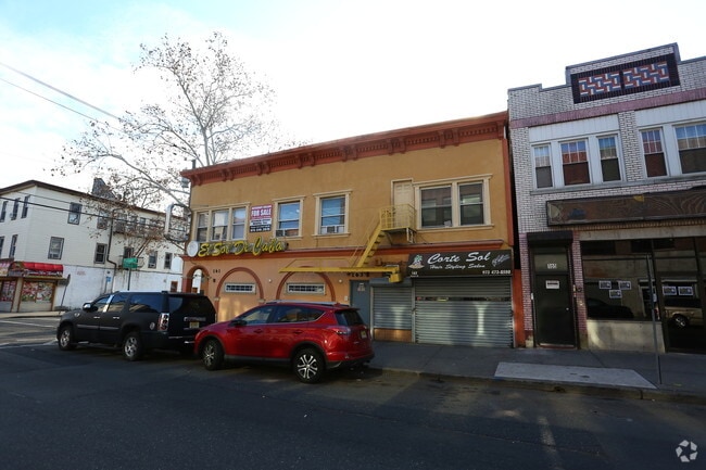
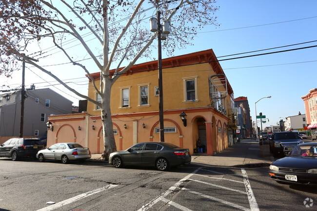
Property Record
161 Passaic St, Passaic, NJ 07055

NEARBY LISTINGS FOR SALE OR LEASE
Property Detail
161 Passaic St
New York-Jersey City-White Plains, NY-NJ
Passaic
07-01035-0000-00007
New Jersey
Sfr
0.12 AC
X
Route 3/GSP
34031C0276G
Northern New Jersey
DEMOGRAPHICS near 161 Passaic St
1 Mile
3 Mile
5 Mile
2024 Total Population
58,401
272,470
621,073
2029 Population
56,694
264,445
605,348
Pop Growth 2024-2029
(2.92%)
(2.95%)
(2.53%)
Average Age
35
39
39
2024 Total Households
18,458
95,050
220,272
HH Growth 2024-2029
(3.17%)
(3.01%)
(2.56%)
Median Household Inc
$49,269
$72,541
$78,031
Avg Household Size
3.00
2.80
2.70
2024 Avg HH Vehicles
1.00
2.00
2.00
Median Home Value
$380,808
$433,010
$426,864
Median Year Built
1948
1952
1954
Nearby Places
Map Layers
Map Styles
 Street
 Aerial
- Restaurants
- Banks
- Shops
- Fitness
- Groceries
PUBLIC TRANSPORTATION
COMMUTER RAIL
Garfield (Bergen County/Port Jervis Line - NJ Transit Commuter Rail (NJ Transit))
DRIVE
WALK
Distance
Garfield (Bergen County/Port Jervis Line - NJ Transit Commuter Rail (NJ Transit))
2 min
13 min
0.7 mi
Wesmont (Main/Bergen County Line - NJ TRANSIT RAIL, Port Jervis Line - NJ TRANSIT RAIL)
DRIVE
WALK
Distance
Wesmont (Main/Bergen County Line - NJ TRANSIT RAIL, Port Jervis Line - NJ TRANSIT RAIL)
8 min
2.8 mi
AIRPORT
Newark Liberty International
DRIVE
WALK
Distance
Newark Liberty International
20 min
15.9 mi
LaGuardia
DRIVE
WALK
Distance
LaGuardia
37 min
21.7 mi
John F Kennedy International
DRIVE
WALK
Distance
John F Kennedy International
48 min
32.8 mi
Freight Ports
Port Newark Container Terminal
DRIVE
WALK
Distance
Port Newark Container Terminal
24 min
15.2 mi
SALE & LEASE HISTORY
LISTING DATE
SALE/LEASE

Sep 23, 2016
For Sale
Nearby Properties
Address
Land Use
TOTAL SIZE
Lot Size
Zoning
Address
Land Use
TOTAL SIZE
Lot Size
Zoning
Address
Land Use
TOTAL SIZE
Lot Size
Zoning
4,014 SF
21 AC
Address
Land Use
TOTAL SIZE
Lot Size
Zoning
612 AC
SEA
Address
Land Use
TOTAL SIZE
Lot Size
Zoning
335.71 AC
AF
Address
Land Use
TOTAL SIZE
Lot Size
Zoning
Address
Land Use
TOTAL SIZE
Lot Size
Zoning
9.57 AC
I2
Address
Land Use
TOTAL SIZE
Lot Size
Zoning
7.10 AC
R-3
Address
Land Use
TOTAL SIZE
Lot Size
Zoning
Address
Land Use
TOTAL SIZE
Lot Size
Zoning
608,596 SF
27.10 AC
LID
Address
Land Use
TOTAL SIZE
Lot Size
Zoning
30.46 AC
I
Address
Land Use
TOTAL SIZE
Lot Size
Zoning
1.12 AC
M-O
Address
Land Use
TOTAL SIZE
Lot Size
Zoning
4.80 AC
Address
Land Use
TOTAL SIZE
Lot Size
Zoning
Address
Land Use
TOTAL SIZE
Lot Size
Zoning
18.30 AC
Address
Land Use
TOTAL SIZE
Lot Size
Zoning
144,024 SF
1 AC
LM
Address
Land Use
TOTAL SIZE
Lot Size
Zoning
25.50 AC
B2
Address
Land Use
TOTAL SIZE
Lot Size
Zoning
26,816 SF
25.50 AC
POP
Address
Land Use
TOTAL SIZE
Lot Size
Zoning
24.29 AC
Address
Land Use
TOTAL SIZE
Lot Size
Zoning
82.74 AC
Address
Land Use
TOTAL SIZE
Lot Size
Zoning
16.94 AC
R2
Address
Land Use
TOTAL SIZE
Lot Size
Zoning
24.35 AC
Address
Land Use
TOTAL SIZE
Lot Size
Zoning
13.80 AC
Address
Land Use
TOTAL SIZE
Lot Size
Zoning
11.30 AC
Address
Land Use
TOTAL SIZE
Lot Size
Zoning
150,018 SF
4.17 AC
B
Address
Land Use
TOTAL SIZE
Lot Size
Zoning
Address
Land Use
TOTAL SIZE
Lot Size
Zoning
13.36 AC
Address
Land Use
TOTAL SIZE
Lot Size
Zoning
136,148 SF
12.81 AC
Address
Land Use
TOTAL SIZE
Lot Size
Zoning
167,920 SF
7.51 AC
IA
Address
Land Use
TOTAL SIZE
Lot Size
Zoning
5.40 AC
RB
Address
Land Use
TOTAL SIZE
Lot Size
Zoning
The World's #1 Commercial Real Estate Marketplace
Connect with us
© 2025 CoStar Group
The information above has been obtained from sources believed reliable. While we do not doubt its accuracy we have not verified it and make no guarantee, warranty or representation about it. It is your responsibility to independently confirm its accuracy and completeness. Any projections, opinions, assumptions, or estimates used are for example only and do not represent the current or future performance of the property. The value of this transaction to you depends on tax and other factors which should be evaluated by your tax, financial, and legal advisors. You and your advisors should conduct a careful, independent investigation of the property to determine to your satisfaction the suitability of the property for your needs.