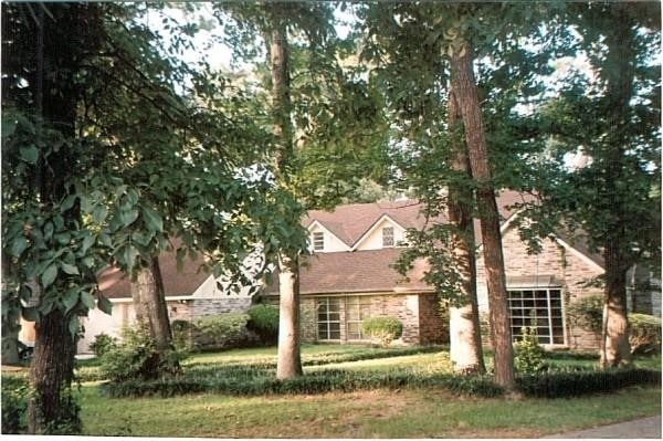
Property Record
1610 Burning Tree Rd, Kingwood, TX 77339


NEARBY LISTINGS FOR SALE OR LEASE
-
-
View all Kingwood listings for sale on LoopNet.com
Property Detail
1610 Burning Tree Rd
Houston-The Woodlands-Sugar Land, TX
Forest Cove Country Club Estates Sec 1
0974820000012
Harris
Sfr
Texas
X
0.41 AC
48339C0750H
Kingwood/Humble
2,833 SF
Houston
DEMOGRAPHICS near 1610 Burning Tree Rd
1 Mile
3 Mile
5 Mile
2024 Total Population
5,797
41,405
154,318
2029 Population
6,352
46,235
164,875
Pop Growth 2024-2029
+ 9.57%
+ 11.67%
+ 6.84%
Average Age
41
40
37
2024 Total Households
2,425
16,184
54,948
HH Growth 2024-2029
+ 11.01%
+ 12.66%
+ 7.39%
Median Household Inc
$59,311
$77,916
$80,469
Avg Household Size
2.30
2.50
2.80
2024 Avg HH Vehicles
2.00
2.00
2.00
Median Home Value
$257,277
$258,553
$232,074
Median Year Built
1998
1999
1995
Nearby Places
Map Layers
Map Styles
 Street
 Aerial
- Restaurants
- Banks
- Shops
- Fitness
- Groceries
PUBLIC TRANSPORTATION
AIRPORT
George Bush Intcntl/Houston
DRIVE
WALK
Distance
George Bush Intcntl/Houston
23 min
14.0 mi
William P Hobby
DRIVE
WALK
Distance
William P Hobby
55 min
35.6 mi
Freight Ports
Port of Houston
DRIVE
WALK
Distance
Port of Houston
44 min
29.3 mi
SALE & LEASE HISTORY
LISTING DATE
SALE/LEASE

Oct 03, 2017
For Sale
Nearby Properties
Address
Land Use
TOTAL SIZE
Lot Size
Zoning
Address
Land Use
TOTAL SIZE
Lot Size
Zoning
687,195 SF
33.75 AC
Address
Land Use
TOTAL SIZE
Lot Size
Zoning
633,347 SF
32.15 AC
5
Address
Land Use
TOTAL SIZE
Lot Size
Zoning
733,100 SF
28.18 AC
Address
Land Use
TOTAL SIZE
Lot Size
Zoning
604,908 SF
58.67 AC
Address
Land Use
TOTAL SIZE
Lot Size
Zoning
363,730 SF
12.59 AC
Address
Land Use
TOTAL SIZE
Lot Size
Zoning
275,500 SF
13.58 AC
Address
Land Use
TOTAL SIZE
Lot Size
Zoning
407,266 SF
25.02 AC
Address
Land Use
TOTAL SIZE
Lot Size
Zoning
288,199 SF
15.50 AC
Address
Land Use
TOTAL SIZE
Lot Size
Zoning
392,395 SF
14.86 AC
5
Address
Land Use
TOTAL SIZE
Lot Size
Zoning
316,815 SF
15.61 AC
Address
Land Use
TOTAL SIZE
Lot Size
Zoning
341,175 SF
65.76 AC
5
Address
Land Use
TOTAL SIZE
Lot Size
Zoning
327,725 SF
22.04 AC
5
Address
Land Use
TOTAL SIZE
Lot Size
Zoning
367,951 SF
26.50 AC
Address
Land Use
TOTAL SIZE
Lot Size
Zoning
284,662 SF
14.60 AC
Address
Land Use
TOTAL SIZE
Lot Size
Zoning
374,791 SF
17.36 AC
Address
Land Use
TOTAL SIZE
Lot Size
Zoning
307,727 SF
14.93 AC
5
Address
Land Use
TOTAL SIZE
Lot Size
Zoning
343,814 SF
12.83 AC
Address
Land Use
TOTAL SIZE
Lot Size
Zoning
237,686 SF
6.53 AC
5
Address
Land Use
TOTAL SIZE
Lot Size
Zoning
201,363 SF
24.98 AC
5
Address
Land Use
TOTAL SIZE
Lot Size
Zoning
125,148 SF
10.73 AC
5
Address
Land Use
TOTAL SIZE
Lot Size
Zoning
194,418 SF
6.93 AC
Address
Land Use
TOTAL SIZE
Lot Size
Zoning
237,552 SF
13.28 AC
5
Address
Land Use
TOTAL SIZE
Lot Size
Zoning
269,585 SF
8.34 AC
Address
Land Use
TOTAL SIZE
Lot Size
Zoning
80,722 SF
28.27 AC
Address
Land Use
TOTAL SIZE
Lot Size
Zoning
156,756 SF
17.05 AC
Address
Land Use
TOTAL SIZE
Lot Size
Zoning
235,072 SF
26.44 AC
5
Address
Land Use
TOTAL SIZE
Lot Size
Zoning
256,120 SF
9.81 AC
Address
Land Use
TOTAL SIZE
Lot Size
Zoning
128,976 SF
16.99 AC
Address
Land Use
TOTAL SIZE
Lot Size
Zoning
192,620 SF
7.46 AC
Address
Land Use
TOTAL SIZE
Lot Size
Zoning
132,930 SF
11.23 AC
The World's #1 Commercial Real Estate Marketplace
Connect with us
© 2026 CoStar Group
The information above has been obtained from sources believed reliable. While we do not doubt its accuracy we have not verified it and make no guarantee, warranty or representation about it. It is your responsibility to independently confirm its accuracy and completeness. Any projections, opinions, assumptions, or estimates used are for example only and do not represent the current or future performance of the property. The value of this transaction to you depends on tax and other factors which should be evaluated by your tax, financial, and legal advisors. You and your advisors should conduct a careful, independent investigation of the property to determine to your satisfaction the suitability of the property for your needs.