Property Record
1611 Bayville St, Norfolk, VA 23503

NEARBY LISTINGS FOR SALE OR LEASE
-
-
View all Norfolk listings for sale on LoopNet.com
Property Detail
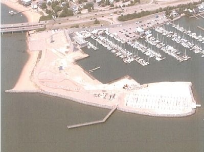
1611 Bayville St
33906502
Subdivision Of Property Of Marina Motor
Stateproperty
PARCEL TWO WILLOUGHBY SPIT
VE
Norfolk City
5101040008H
Virginia
2025
8.07 AC
2025
Airport/Northampton
000400
Hampton Roads
6,150 SF
Virginia Beach-Norfolk-Newport News, VA-NC
DEMOGRAPHICS near 1611 Bayville St
1 Mile
3 Mile
5 Mile
2024 Total Population
2,040
31,939
102,046
2029 Population
2,039
31,188
100,341
Pop Growth 2024-2029
(0.05%)
(2.35%)
(1.67%)
Average Age
40
32
36
2024 Total Households
1,058
8,624
37,516
HH Growth 2024-2029
(0.28%)
(2.63%)
(1.89%)
Median Household Inc
$57,150
$55,260
$59,510
Avg Household Size
1.90
2.20
2.20
2024 Avg HH Vehicles
1.00
2.00
2.00
Median Home Value
$320,312
$260,792
$250,476
Median Year Built
1974
1965
1961
Nearby Places
Map Layers
Map Styles
 Street
 Aerial
- Restaurants
- Banks
- Shops
- Fitness
- Groceries
PUBLIC TRANSPORTATION
AIRPORT
Norfolk International
DRIVE
WALK
Distance
Norfolk International
16 min
9.8 mi
Newport News/Williamsburg International
DRIVE
WALK
Distance
Newport News/Williamsburg International
30 min
19.8 mi
Freight Ports
Virginia Port Authority - Norfolk
DRIVE
WALK
Distance
Virginia Port Authority - Norfolk
18 min
8.7 mi
Nearby Properties
Address
Land Use
TOTAL SIZE
Lot Size
Zoning
Address
Land Use
TOTAL SIZE
Lot Size
Zoning
3,436.58 AC
Address
Land Use
TOTAL SIZE
Lot Size
Zoning
777.89 AC
Address
Land Use
TOTAL SIZE
Lot Size
Zoning
7,644 SF
322.21 AC
19 PO-1 GE
Address
Land Use
TOTAL SIZE
Lot Size
Zoning
8,423 SF
53.95 AC
Address
Land Use
TOTAL SIZE
Lot Size
Zoning
103,496 SF
25.81 AC
IN1
Address
Land Use
TOTAL SIZE
Lot Size
Zoning
11.09 AC
R14
Address
Land Use
TOTAL SIZE
Lot Size
Zoning
14.02 AC
Address
Land Use
TOTAL SIZE
Lot Size
Zoning
68.02 AC
Address
Land Use
TOTAL SIZE
Lot Size
Zoning
23.85 AC
IN1
Address
Land Use
TOTAL SIZE
Lot Size
Zoning
2,106 SF
191.59 AC
42 FM-1 FO
Address
Land Use
TOTAL SIZE
Lot Size
Zoning
204,803 SF
4.97 AC
43 FM-2 FO
Address
Land Use
TOTAL SIZE
Lot Size
Zoning
47,168 SF
4.87 AC
R14
Address
Land Use
TOTAL SIZE
Lot Size
Zoning
36,960 SF
5.17 AC
R14
Address
Land Use
TOTAL SIZE
Lot Size
Zoning
28,064 SF
7.48 AC
C2
Address
Land Use
TOTAL SIZE
Lot Size
Zoning
28,708 SF
3.16 AC
C2
Address
Land Use
TOTAL SIZE
Lot Size
Zoning
69,000 SF
6.46 AC
IN1
Address
Land Use
TOTAL SIZE
Lot Size
Zoning
41.44 AC
C2
Address
Land Use
TOTAL SIZE
Lot Size
Zoning
50,760 SF
1.70 AC
C2
Address
Land Use
TOTAL SIZE
Lot Size
Zoning
26,080 SF
6.93 AC
C2
Address
Land Use
TOTAL SIZE
Lot Size
Zoning
53,229 SF
6.81 AC
IN1
Address
Land Use
TOTAL SIZE
Lot Size
Zoning
32.93 AC
Address
Land Use
TOTAL SIZE
Lot Size
Zoning
41,316 SF
2.45 AC
R12
Address
Land Use
TOTAL SIZE
Lot Size
Zoning
8.36 AC
C2
Address
Land Use
TOTAL SIZE
Lot Size
Zoning
55,742 SF
5.92 AC
C2
Address
Land Use
TOTAL SIZE
Lot Size
Zoning
18,478 SF
1.21 AC
IN1
Address
Land Use
TOTAL SIZE
Lot Size
Zoning
22,393 SF
0.80 AC
R8
Address
Land Use
TOTAL SIZE
Lot Size
Zoning
38,893 SF
1.80 AC
R6
Address
Land Use
TOTAL SIZE
Lot Size
Zoning
29,609 SF
0.78 AC
IN1
Address
Land Use
TOTAL SIZE
Lot Size
Zoning
4,704 SF
0.86 AC
R12
The World's #1 Commercial Real Estate Marketplace
Connect with us
© 2025 CoStar Group
The information above has been obtained from sources believed reliable. While we do not doubt its accuracy we have not verified it and make no guarantee, warranty or representation about it. It is your responsibility to independently confirm its accuracy and completeness. Any projections, opinions, assumptions, or estimates used are for example only and do not represent the current or future performance of the property. The value of this transaction to you depends on tax and other factors which should be evaluated by your tax, financial, and legal advisors. You and your advisors should conduct a careful, independent investigation of the property to determine to your satisfaction the suitability of the property for your needs.