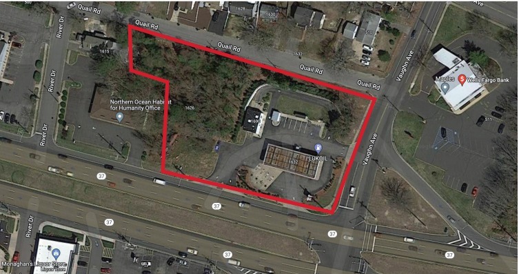
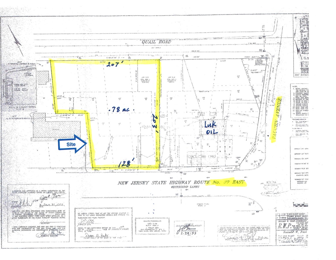
Property Record
1626 Route 37 E, Toms River, NJ 08753
NEARBY LISTINGS FOR SALE OR LEASE
Property Detail
1626 Route 37 E
Commercialnec
Ocean
X
New Jersey
34029C0309F
5.1
2023
Ocean County
2024
Northern New Jersey
723200
New York-Jersey City-White Plains, NY-NJ
600 SF
08-01086-14-00005-01-B02
DEMOGRAPHICS near 1626 Route 37 E
1 Mile
3 Mile
5 Mile
2024 Total Population
10,166
67,885
139,899
2029 Population
10,780
72,128
150,786
Pop Growth 2024-2029
+ 6.04%
+ 6.25%
+ 7.78%
Average Age
39
39
42
2024 Total Households
3,666
24,708
54,134
HH Growth 2024-2029
+ 5.73%
+ 5.79%
+ 7.78%
Median Household Inc
$75,693
$88,111
$84,417
Avg Household Size
2.60
2.60
2.50
2024 Avg HH Vehicles
2.00
2.00
2.00
Median Home Value
$318,733
$322,082
$342,234
Median Year Built
1968
1973
1975
Nearby Places
- Restaurants
- Banks
- Shops
- Fitness
- Groceries
SALE & LEASE HISTORY
LISTING DATE
SALE/LEASE

Aug 23, 2023
For Sale
Apr 14, 2017
For Lease
Nearby Properties
Address
Land Use
TOTAL SIZE
Lot Size
Zoning
Address
Land Use
TOTAL SIZE
Lot Size
Zoning
70.33 AC
RC
Address
Land Use
TOTAL SIZE
Lot Size
Zoning
22,175 SF
30.21 AC
RC
Address
Land Use
TOTAL SIZE
Lot Size
Zoning
4,584 SF
11.85 AC
VO
Address
Land Use
TOTAL SIZE
Lot Size
Zoning
8,512 SF
25.67 AC
RC
Address
Land Use
TOTAL SIZE
Lot Size
Zoning
18,046 SF
22.43 AC
HB
Address
Land Use
TOTAL SIZE
Lot Size
Zoning
8,118 SF
72.32 AC
R75
Address
Land Use
TOTAL SIZE
Lot Size
Zoning
8.21 AC
VO
Address
Land Use
TOTAL SIZE
Lot Size
Zoning
8,968 SF
26.36 AC
RMF
Address
Land Use
TOTAL SIZE
Lot Size
Zoning
1,000 SF
14.63 AC
RC
Address
Land Use
TOTAL SIZE
Lot Size
Zoning
11,302 SF
13.76 AC
EM18
Address
Land Use
TOTAL SIZE
Lot Size
Zoning
18,890 SF
24.59 AC
SPLT
Address
Land Use
TOTAL SIZE
Lot Size
Zoning
46,332 SF
8.85 AC
SPLT
Address
Land Use
TOTAL SIZE
Lot Size
Zoning
19,836 SF
13.03 AC
EM18
Address
Land Use
TOTAL SIZE
Lot Size
Zoning
13.96 AC
O10
Address
Land Use
TOTAL SIZE
Lot Size
Zoning
15.68 AC
MF8
Address
Land Use
TOTAL SIZE
Lot Size
Zoning
2,549 SF
16.02 AC
RC
Address
Land Use
TOTAL SIZE
Lot Size
Zoning
3,997 SF
11.09 AC
RC
Address
Land Use
TOTAL SIZE
Lot Size
Zoning
3,632 SF
189.71 AC
R400
Address
Land Use
TOTAL SIZE
Lot Size
Zoning
24,394 SF
7.66 AC
EM18
Address
Land Use
TOTAL SIZE
Lot Size
Zoning
9,874 SF
15.17 AC
RC
Address
Land Use
TOTAL SIZE
Lot Size
Zoning
1.98 AC
HB
Address
Land Use
TOTAL SIZE
Lot Size
Zoning
1,680 SF
14.33 AC
HB
Address
Land Use
TOTAL SIZE
Lot Size
Zoning
3,830 SF
24.23 AC
R120
Address
Land Use
TOTAL SIZE
Lot Size
Zoning
33.59 AC
R90
Address
Land Use
TOTAL SIZE
Lot Size
Zoning
1,308 SF
2.14 AC
VO
Address
Land Use
TOTAL SIZE
Lot Size
Zoning
22.29 AC
HB
Address
Land Use
TOTAL SIZE
Lot Size
Zoning
10,360 SF
11.56 AC
HB
Address
Land Use
TOTAL SIZE
Lot Size
Zoning
1,170 SF
27.24 AC
R90
Address
Land Use
TOTAL SIZE
Lot Size
Zoning
3,524 SF
10 AC
HB
Address
Land Use
TOTAL SIZE
Lot Size
Zoning
2,796 SF
13.55 AC
RC
The World's #1 Commercial Real Estate Marketplace
Connect with us
© 2025 CoStar Group
The information above has been obtained from sources believed reliable. While we do not doubt its accuracy we have not verified it and make no guarantee, warranty or representation about it. It is your responsibility to independently confirm its accuracy and completeness. Any projections, opinions, assumptions, or estimates used are for example only and do not represent the current or future performance of the property. The value of this transaction to you depends on tax and other factors which should be evaluated by your tax, financial, and legal advisors. You and your advisors should conduct a careful, independent investigation of the property to determine to your satisfaction the suitability of the property for your needs.