Property Record
1640 Garces Hwy, Delano, CA 93215


NEARBY LISTINGS FOR SALE OR LEASE
-
-
View all Delano listings for sale on LoopNet.com
Property Detail
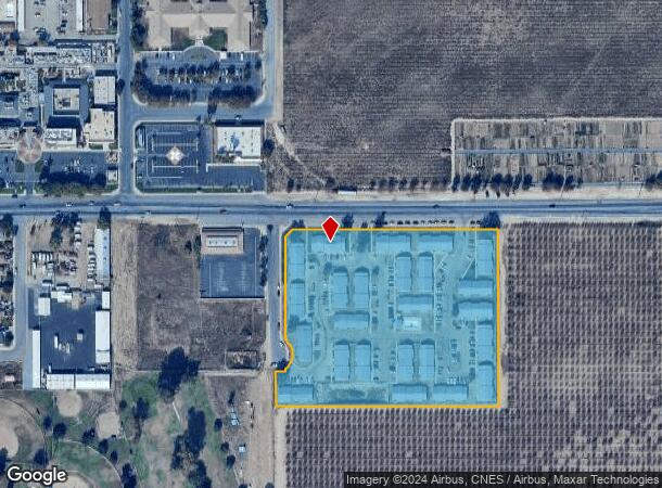
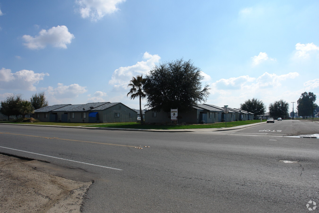
1640 Garces Hwy
Bakersfield, CA
Parcel Map 7480
424-020-10-00-5
PARCEL MAP 7480 , LOT 1
Apartment
Kern
X
California
06107C2300E
1
2023
7.43 AC
2024
Northern Kern County
005003
Bakersfield
89,664 SF
DEMOGRAPHICS near 1640 Garces Hwy
1 Mile
3 Mile
5 Mile
2024 Total Population
13,285
43,795
44,534
2029 Population
13,167
43,542
44,269
Pop Growth 2024-2029
(0.89%)
(0.58%)
(0.60%)
Average Age
34
34
34
2024 Total Households
3,512
11,120
11,299
HH Growth 2024-2029
(0.83%)
(0.58%)
(0.59%)
Median Household Inc
$42,692
$47,866
$47,746
Avg Household Size
3.60
3.80
3.80
2024 Avg HH Vehicles
2.00
2.00
2.00
Median Home Value
$249,310
$259,496
$259,672
Median Year Built
1978
1986
1986
Nearby Places
- Restaurants
- Banks
- Shops
- Fitness
- Groceries
PUBLIC TRANSPORTATION
AIRPORT
Meadows Field
DRIVE
WALK
Distance
Meadows Field
38 min
28.5 mi
Freight Ports
The Port of Hueneme
DRIVE
WALK
Distance
The Port of Hueneme
186 min
153.2 mi
Nearby Properties
Address
Land Use
TOTAL SIZE
Lot Size
Zoning
Address
Land Use
TOTAL SIZE
Lot Size
Zoning
33.33 AC
Address
Land Use
TOTAL SIZE
Lot Size
Zoning
22.76 AC
Address
Land Use
TOTAL SIZE
Lot Size
Zoning
1,197,504 SF
80.46 AC
M1
Address
Land Use
TOTAL SIZE
Lot Size
Zoning
115,071 SF
46.83 AC
R-1
Address
Land Use
TOTAL SIZE
Lot Size
Zoning
13,558 SF
5.53 AC
GC
Address
Land Use
TOTAL SIZE
Lot Size
Zoning
14.56 AC
SP
Address
Land Use
TOTAL SIZE
Lot Size
Zoning
233,028 SF
11.76 AC
G-C
Address
Land Use
TOTAL SIZE
Lot Size
Zoning
1,891 SF
20.03 AC
A
Address
Land Use
TOTAL SIZE
Lot Size
Zoning
190,069 SF
18 AC
CRC
Address
Land Use
TOTAL SIZE
Lot Size
Zoning
89,941 SF
11.22 AC
CRC
Address
Land Use
TOTAL SIZE
Lot Size
Zoning
80,178 SF
4.65 AC
R-3
Address
Land Use
TOTAL SIZE
Lot Size
Zoning
87,580 SF
12 AC
A-1
Address
Land Use
TOTAL SIZE
Lot Size
Zoning
67,951 SF
3.42 AC
I
Address
Land Use
TOTAL SIZE
Lot Size
Zoning
68,994 SF
4.83 AC
R-2
Address
Land Use
TOTAL SIZE
Lot Size
Zoning
3,179 SF
5.45 AC
R-3
Address
Land Use
TOTAL SIZE
Lot Size
Zoning
68,077 SF
10 AC
GC
Address
Land Use
TOTAL SIZE
Lot Size
Zoning
67,645 SF
4.71 AC
Address
Land Use
TOTAL SIZE
Lot Size
Zoning
61,600 SF
4.49 AC
R-3
Address
Land Use
TOTAL SIZE
Lot Size
Zoning
1.77 AC
Address
Land Use
TOTAL SIZE
Lot Size
Zoning
1,800 SF
4.49 AC
C1
Address
Land Use
TOTAL SIZE
Lot Size
Zoning
18,538 SF
7.25 AC
R-1
Address
Land Use
TOTAL SIZE
Lot Size
Zoning
34,608 SF
1.59 AC
C1
Address
Land Use
TOTAL SIZE
Lot Size
Zoning
17,206 SF
2.27 AC
GC
Address
Land Use
TOTAL SIZE
Lot Size
Zoning
28,560 SF
9.51 AC
R-3
Address
Land Use
TOTAL SIZE
Lot Size
Zoning
34,064 SF
3.37 AC
GC
Address
Land Use
TOTAL SIZE
Lot Size
Zoning
84,767 SF
4.88 AC
Address
Land Use
TOTAL SIZE
Lot Size
Zoning
21,246 SF
0.54 AC
GC
Address
Land Use
TOTAL SIZE
Lot Size
Zoning
13,052 SF
1.77 AC
GC
Address
Land Use
TOTAL SIZE
Lot Size
Zoning
1,170 SF
11.43 AC
M-3
Address
Land Use
TOTAL SIZE
Lot Size
Zoning
2.54 AC
The World's #1 Commercial Real Estate Marketplace
Connect with us
© 2025 CoStar Group
The information above has been obtained from sources believed reliable. While we do not doubt its accuracy we have not verified it and make no guarantee, warranty or representation about it. It is your responsibility to independently confirm its accuracy and completeness. Any projections, opinions, assumptions, or estimates used are for example only and do not represent the current or future performance of the property. The value of this transaction to you depends on tax and other factors which should be evaluated by your tax, financial, and legal advisors. You and your advisors should conduct a careful, independent investigation of the property to determine to your satisfaction the suitability of the property for your needs.