Property Record
16408 N County Road 3208, Pauls Valley, OK 73075
NEARBY LISTINGS FOR SALE OR LEASE
Property Detail
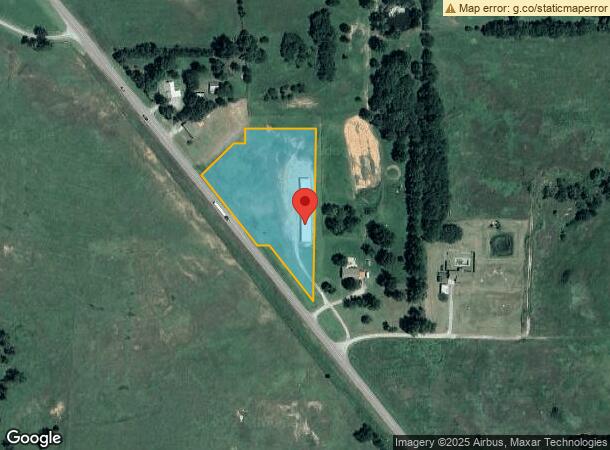
16408 N County Road 3208
0000-03-03N-01W-0-600-00
Thunder Ridge
Publicstorage
COM NE/C E/2 SW S943.67' W362.80'PB S551.70' NW226.33' W38.50' NW291.75' NE148.77' E33.19' N45.46' E219.87' PB (2.71A MOL) WD
X
Garvin
40049C0100D
Oklahoma
2024
2.71 AC
2024
Oklahoma East Area
681200
Other Market Areas
2,940 SF
DEMOGRAPHICS near 16408 N County Road 3208
1 Mile
3 Mile
5 Mile
2024 Total Population
162
843
6,903
2029 Population
156
823
6,996
Pop Growth 2024-2029
(3.70%)
(2.37%)
+ 1.35%
Average Age
44
43
41
2024 Total Households
66
336
2,745
HH Growth 2024-2029
(4.55%)
(2.38%)
+ 1.35%
Median Household Inc
$53,000
$50,179
$43,256
Avg Household Size
2.50
2.50
2.40
2024 Avg HH Vehicles
2.00
2.00
2.00
Median Home Value
$183,333
$171,874
$124,116
Median Year Built
1974
1974
1967
Nearby Places
- Restaurants
- Banks
- Shops
- Fitness
- Groceries
PUBLIC TRANSPORTATION
COMMUTER RAIL
Pauls Valley Amtrak Station (Heartland Flyer - Amtrak)
DRIVE
WALK
Distance
Pauls Valley Amtrak Station (Heartland Flyer - Amtrak)
8 min
5.1 mi
Freight Ports
Tulsa Port Of Catoosa
DRIVE
WALK
Distance
Tulsa Port Of Catoosa
193 min
176.1 mi
SALE & LEASE HISTORY
LISTING DATE
SALE/LEASE

Sep 24, 2016
For Sale
Jun 16, 2017
For Sale
Nearby Properties
Address
Land Use
TOTAL SIZE
Lot Size
Zoning
Address
Land Use
TOTAL SIZE
Lot Size
Zoning
24,967 SF
93.31 AC
NP
Address
Land Use
TOTAL SIZE
Lot Size
Zoning
104,307 SF
16.21 AC
Address
Land Use
TOTAL SIZE
Lot Size
Zoning
54,056 SF
2.07 AC
Address
Land Use
TOTAL SIZE
Lot Size
Zoning
8,080 SF
15 AC
C1
Address
Land Use
TOTAL SIZE
Lot Size
Zoning
40,794 SF
2.38 AC
Address
Land Use
TOTAL SIZE
Lot Size
Zoning
35,031 SF
2.08 AC
Address
Land Use
TOTAL SIZE
Lot Size
Zoning
37,250 SF
1.79 AC
Address
Land Use
TOTAL SIZE
Lot Size
Zoning
1,840 SF
5.02 AC
C1
Address
Land Use
TOTAL SIZE
Lot Size
Zoning
6,272 SF
1.40 AC
Address
Land Use
TOTAL SIZE
Lot Size
Zoning
4,056 SF
3.12 AC
Address
Land Use
TOTAL SIZE
Lot Size
Zoning
184,902 SF
10 AC
C1
Address
Land Use
TOTAL SIZE
Lot Size
Zoning
7,000 SF
1 AC
C1
Address
Land Use
TOTAL SIZE
Lot Size
Zoning
22,286 SF
0.99 AC
C1
Address
Land Use
TOTAL SIZE
Lot Size
Zoning
16,686 SF
2.42 AC
Address
Land Use
TOTAL SIZE
Lot Size
Zoning
7,680 SF
5.50 AC
Address
Land Use
TOTAL SIZE
Lot Size
Zoning
4,456 SF
2.73 AC
C1
Address
Land Use
TOTAL SIZE
Lot Size
Zoning
4,475 SF
0.92 AC
C1
Address
Land Use
TOTAL SIZE
Lot Size
Zoning
1,912 SF
3.50 AC
C1
Address
Land Use
TOTAL SIZE
Lot Size
Zoning
3,428 SF
2 AC
C1
Address
Land Use
TOTAL SIZE
Lot Size
Zoning
5,941 SF
0.99 AC
Address
Land Use
TOTAL SIZE
Lot Size
Zoning
9,746 SF
2.71 AC
C1
Address
Land Use
TOTAL SIZE
Lot Size
Zoning
9,886 SF
2.27 AC
C1
Address
Land Use
TOTAL SIZE
Lot Size
Zoning
5,432 SF
1.16 AC
Address
Land Use
TOTAL SIZE
Lot Size
Zoning
1,500 SF
0.98 AC
C1
Address
Land Use
TOTAL SIZE
Lot Size
Zoning
4,042 SF
1.68 AC
Address
Land Use
TOTAL SIZE
Lot Size
Zoning
3,754 SF
0.95 AC
C1
Address
Land Use
TOTAL SIZE
Lot Size
Zoning
45,000 SF
5.88 AC
C1
Address
Land Use
TOTAL SIZE
Lot Size
Zoning
2,146 SF
1 AC
C1
The World's #1 Commercial Real Estate Marketplace
Connect with us
© 2025 CoStar Group
The information above has been obtained from sources believed reliable. While we do not doubt its accuracy we have not verified it and make no guarantee, warranty or representation about it. It is your responsibility to independently confirm its accuracy and completeness. Any projections, opinions, assumptions, or estimates used are for example only and do not represent the current or future performance of the property. The value of this transaction to you depends on tax and other factors which should be evaluated by your tax, financial, and legal advisors. You and your advisors should conduct a careful, independent investigation of the property to determine to your satisfaction the suitability of the property for your needs.