Property Record
16434 N Dale Mabry Hwy, Tampa, FL 33618
Current Lease Availabilities
NEARBY LISTINGS FOR SALE OR LEASE
Property Detail
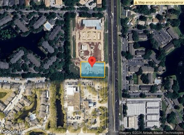
16434 N Dale Mabry Hwy
Tampa-St. Petersburg-Clearwater, FL
Unplatted
U-28-27-18-ZZZ-000000-67370.0
A PORTION OF A PARCEL OF LAND DESC IN OR BK 5390 PG 247 SITUATE IN SEC 28 TWP 27 SOUTH RGE 18 EAST BEING MORE PARTICULARLY DESC AS FOLLOWS: BEG AT SOUTHEAST COR OF SD DESC LAND SITUATE ON WEST R/W LINE OF NORTH DALE MABRY HWY THN DEPARTING SD WEST R/
Commercialacreage
Hillsborough
X
Florida
12057C0182H
67370
2023
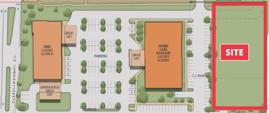
1.10 AC
2023
Northwest Tampa
011524
Tampa/St Petersburg
2,920 SF
DEMOGRAPHICS near 16434 N Dale Mabry Hwy
1 Mile
3 Mile
5 Mile
2024 Total Population
12,380
63,860
191,943
2029 Population
13,502
69,638
209,282
Pop Growth 2024-2029
+ 9.06%
+ 9.05%
+ 9.03%
Average Age
40
43
41
2024 Total Households
5,247
25,938
75,708
HH Growth 2024-2029
+ 9.26%
+ 9.33%
+ 9.28%
Median Household Inc
$64,479
$84,409
$70,876
Avg Household Size
2.30
2.40
2.50
2024 Avg HH Vehicles
2.00
2.00
2.00
Median Home Value
$327,244
$376,951
$357,136
Median Year Built
1986
1985
1985
Nearby Places
- Restaurants
- Banks
- Shops
- Fitness
- Groceries
PUBLIC TRANSPORTATION
AIRPORT
Tampa International
Drive
Walk
Distance
Tampa International
25 min
13.0 mi
St Pete-Clearwater International
Drive
Walk
Distance
St Pete-Clearwater International
45 min
24.6 mi
Freight Ports
Port of Tampa Bay
Drive
Walk
Distance
Port of Tampa Bay
30 min
17.2 mi
Nearby Properties
Address
Land Use
TOTAL SIZE
Lot Size
Zoning
Address
Land Use
TOTAL SIZE
Lot Size
Zoning
1800698
475.85 AC
PD
Address
Land Use
TOTAL SIZE
Lot Size
Zoning
452046
40.02 AC
PD
Address
Land Use
TOTAL SIZE
Lot Size
Zoning
444470
147.01 AC
AR
Address
Land Use
TOTAL SIZE
Lot Size
Zoning
383193
13.07 AC
PD
Address
Land Use
TOTAL SIZE
Lot Size
Zoning
469745
73.96 AC
PD
Address
Land Use
TOTAL SIZE
Lot Size
Zoning
431984
38.98 AC
PD
Address
Land Use
TOTAL SIZE
Lot Size
Zoning
377405
35.23 AC
PD
Address
Land Use
TOTAL SIZE
Lot Size
Zoning
336275
69.79 AC
PD
Address
Land Use
TOTAL SIZE
Lot Size
Zoning
207337
11.54 AC
PD
Address
Land Use
TOTAL SIZE
Lot Size
Zoning
292105
25.02 AC
PD
Address
Land Use
TOTAL SIZE
Lot Size
Zoning
382836
29.68 AC
PD
Address
Land Use
TOTAL SIZE
Lot Size
Zoning
202594
38.31 AC
RSC-2
Address
Land Use
TOTAL SIZE
Lot Size
Zoning
198886
18.37 AC
PD
Address
Land Use
TOTAL SIZE
Lot Size
Zoning
274467
27.94 AC
PD
Address
Land Use
TOTAL SIZE
Lot Size
Zoning
190430
14.97 AC
PD
Address
Land Use
TOTAL SIZE
Lot Size
Zoning
174587
14.60 AC
PD
Address
Land Use
TOTAL SIZE
Lot Size
Zoning
183615
15.14 AC
PD
Address
Land Use
TOTAL SIZE
Lot Size
Zoning
142116
20.82 AC
PD
Address
Land Use
TOTAL SIZE
Lot Size
Zoning
125445
15.80 AC
PD
Address
Land Use
TOTAL SIZE
Lot Size
Zoning
170565
15.37 AC
PD
Address
Land Use
TOTAL SIZE
Lot Size
Zoning
107714
9.65 AC
PD
Address
Land Use
TOTAL SIZE
Lot Size
Zoning
158196
33.06 AC
PD
Address
Land Use
TOTAL SIZE
Lot Size
Zoning
195136
21.46 AC
PD
Address
Land Use
TOTAL SIZE
Lot Size
Zoning
302030
51.83 AC
AS-1
Address
Land Use
TOTAL SIZE
Lot Size
Zoning
133800
9.31 AC
RMC-20
Address
Land Use
TOTAL SIZE
Lot Size
Zoning
115361
28.52 AC
ASC-1
Address
Land Use
TOTAL SIZE
Lot Size
Zoning
109438
9.59 AC
PD
Address
Land Use
TOTAL SIZE
Lot Size
Zoning
104901
26.71 AC
PD
Address
Land Use
TOTAL SIZE
Lot Size
Zoning
106307
9.58 AC
PD
Address
Land Use
TOTAL SIZE
Lot Size
Zoning
192120
21.04 AC
PD
Start a new search to find other properties for sale or lease
Connect with us
© 2024 CoStar Group
The information above has been obtained from sources believed reliable. While we do not doubt its accuracy we have not verified it and make no guarantee, warranty or representation about it. It is your responsibility to independently confirm its accuracy and completeness. Any projections, opinions, assumptions, or estimates used are for example only and do not represent the current or future performance of the property. The value of this transaction to you depends on tax and other factors which should be evaluated by your tax, financial, and legal advisors. You and your advisors should conduct a careful, independent investigation of the property to determine to your satisfaction the suitability of the property for your needs.