Property Record
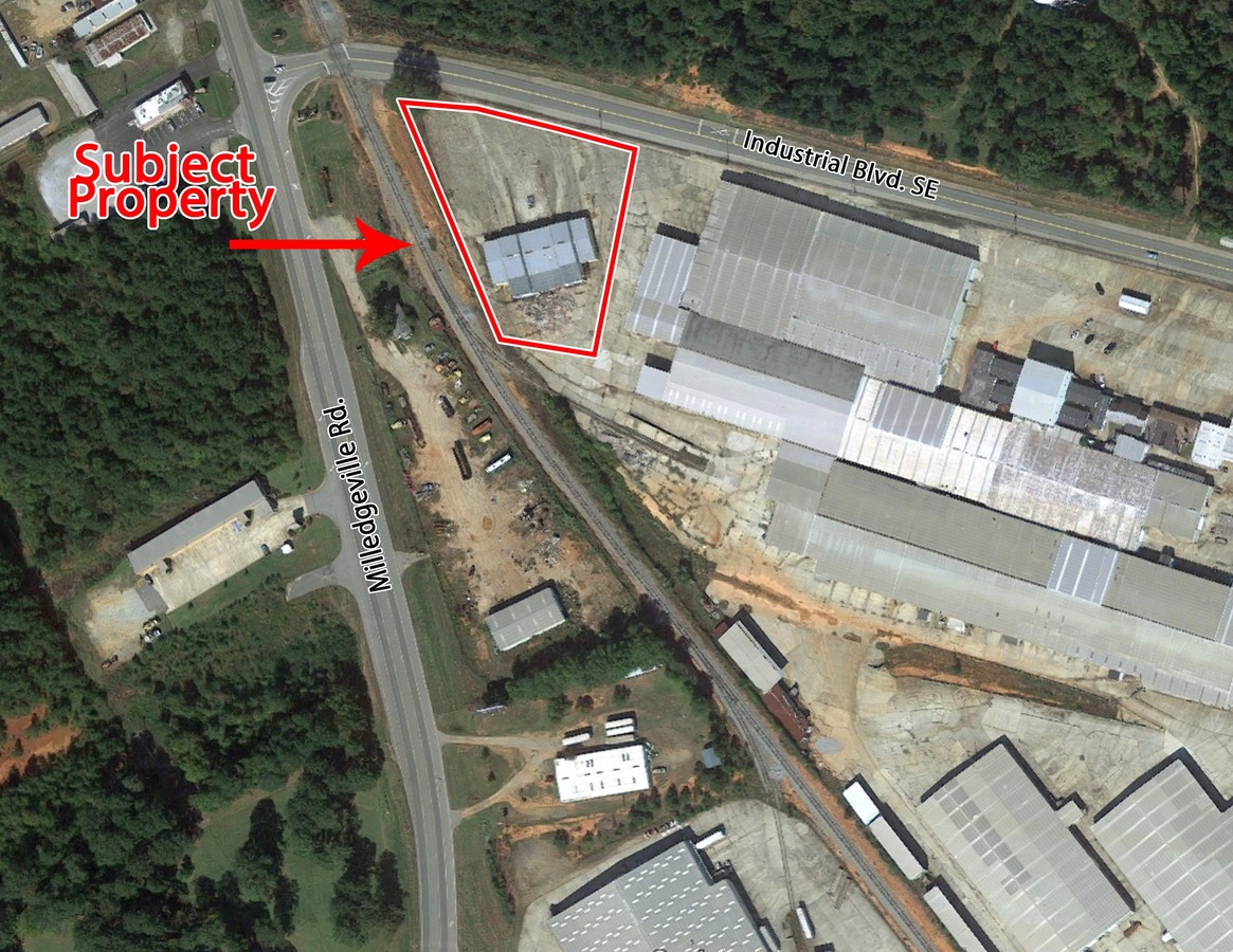
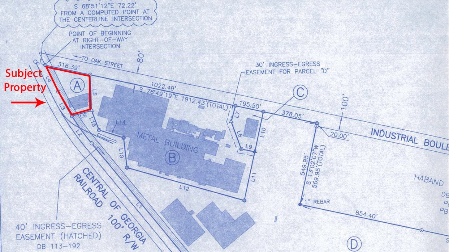
165 Industrial Blvd, Eatonton, GA 31024
NEARBY LISTINGS FOR SALE OR LEASE
-
-
View all Eatonton listings for sale on LoopNet.com
Property Detail
165 Industrial Blvd
062-050
Industrial 53
Warehouse
HORTON IRON WORKS
X
Putnam
13141C0125B
Georgia
2024
5 AC
2024
Georgia Northeast
960204
Other Market Areas
36,000 SF
DEMOGRAPHICS near 165 Industrial Blvd
1 Mile
3 Mile
5 Mile
2024 Total Population
168
5,083
6,804
2029 Population
182
5,489
7,374
Pop Growth 2024-2029
+ 8.33%
+ 7.99%
+ 8.38%
Average Age
39
40
40
2024 Total Households
65
1,990
2,654
HH Growth 2024-2029
+ 7.69%
+ 8.19%
+ 8.67%
Median Household Inc
$51,000
$42,291
$42,621
Avg Household Size
2.50
2.50
2.50
2024 Avg HH Vehicles
2.00
2.00
2.00
Median Home Value
$121,428
$147,417
$146,562
Median Year Built
1990
1982
1982
Nearby Places
- Restaurants
- Banks
- Shops
- Fitness
- Groceries
SALE & LEASE HISTORY
LISTING DATE
SALE/LEASE

Oct 03, 2016
For Sale
Nearby Properties
Address
Land Use
TOTAL SIZE
Lot Size
Zoning
Address
Land Use
TOTAL SIZE
Lot Size
Zoning
149,526 SF
60 AC
A-1 CITY
Address
Land Use
TOTAL SIZE
Lot Size
Zoning
64,786 SF
12.20 AC
PUBLIC CIT
Address
Land Use
TOTAL SIZE
Lot Size
Zoning
56,712 SF
2.79 AC
PUBLIC
Address
Land Use
TOTAL SIZE
Lot Size
Zoning
8,000 SF
14.17 AC
PUBLIC CIT
Address
Land Use
TOTAL SIZE
Lot Size
Zoning
30,000 SF
30.90 AC
I-2 CITY
Address
Land Use
TOTAL SIZE
Lot Size
Zoning
30,867 SF
3.01 AC
R-3 CITY
Address
Land Use
TOTAL SIZE
Lot Size
Zoning
7,800 SF
40.10 AC
PUBLIC CIT
Address
Land Use
TOTAL SIZE
Lot Size
Zoning
9,785 SF
1.35 AC
R-1 CITY
Address
Land Use
TOTAL SIZE
Lot Size
Zoning
430.87 AC
AG
Address
Land Use
TOTAL SIZE
Lot Size
Zoning
2,209.80 AC
AG
Address
Land Use
TOTAL SIZE
Lot Size
Zoning
130,923 SF
19.41 AC
C-2 CITY
Address
Land Use
TOTAL SIZE
Lot Size
Zoning
22,685 SF
2.06 AC
PUBLIC
Address
Land Use
TOTAL SIZE
Lot Size
Zoning
3,051 SF
7.13 AC
R-3 CITY
Address
Land Use
TOTAL SIZE
Lot Size
Zoning
1,229.62 AC
AG
Address
Land Use
TOTAL SIZE
Lot Size
Zoning
169,300 SF
24.79 AC
I-2 CITY
Address
Land Use
TOTAL SIZE
Lot Size
Zoning
25,686 SF
29.53 AC
PUBLIC CIT
Address
Land Use
TOTAL SIZE
Lot Size
Zoning
121,200 SF
2.75 AC
I-2 CITY
Address
Land Use
TOTAL SIZE
Lot Size
Zoning
1,290.30 AC
AG
Address
Land Use
TOTAL SIZE
Lot Size
Zoning
749.45 AC
AG
Address
Land Use
TOTAL SIZE
Lot Size
Zoning
20,350 SF
1.64 AC
C-1 CITY
Address
Land Use
TOTAL SIZE
Lot Size
Zoning
3,000 SF
1.61 AC
C-2
Address
Land Use
TOTAL SIZE
Lot Size
Zoning
14,267 SF
18.97 AC
PUBLIC
Address
Land Use
TOTAL SIZE
Lot Size
Zoning
14,390 SF
13.86 AC
R-2 CITY
Address
Land Use
TOTAL SIZE
Lot Size
Zoning
1,848 SF
6.25 AC
R-3 CITY
Address
Land Use
TOTAL SIZE
Lot Size
Zoning
1,920 SF
83.80 AC
PUBLIC CIT
Address
Land Use
TOTAL SIZE
Lot Size
Zoning
10,800 SF
2.51 AC
C-2
Address
Land Use
TOTAL SIZE
Lot Size
Zoning
11,930 SF
1 AC
C-2 CITY
Address
Land Use
TOTAL SIZE
Lot Size
Zoning
992.58 AC
AG
Address
Land Use
TOTAL SIZE
Lot Size
Zoning
25,125 SF
23 AC
PUBLIC CIT
Address
Land Use
TOTAL SIZE
Lot Size
Zoning
338,000 SF
50 AC
I-2 CITY
The World's #1 Commercial Real Estate Marketplace
Connect with us
© 2025 CoStar Group
The information above has been obtained from sources believed reliable. While we do not doubt its accuracy we have not verified it and make no guarantee, warranty or representation about it. It is your responsibility to independently confirm its accuracy and completeness. Any projections, opinions, assumptions, or estimates used are for example only and do not represent the current or future performance of the property. The value of this transaction to you depends on tax and other factors which should be evaluated by your tax, financial, and legal advisors. You and your advisors should conduct a careful, independent investigation of the property to determine to your satisfaction the suitability of the property for your needs.