Property Record
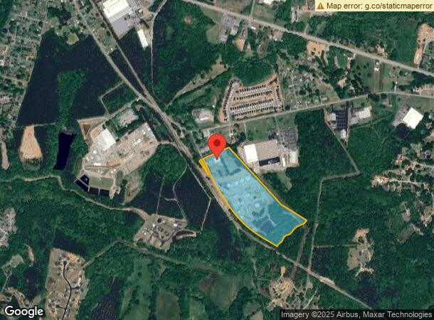
165 Lawson Fork Rd, Inman, SC 29349
NEARBY LISTINGS FOR SALE OR LEASE
-
-
View all Inman listings for sale on LoopNet.com
Property Detail
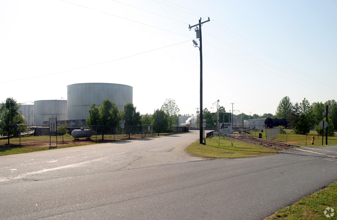
165 Lawson Fork Rd
2-49-00-002.01
E & W SIDES OF LAWSON FORK RD & S OF OLD HOWARD GAP RD PB 99-690 PB 119-244-244A PB 122-175
Warehouse
Spartanburg
AE
South Carolina
45083C0143D
36.05 AC
2024
Upper Spartanburg County
2023
Greenville/Spartanburg
022804
Spartanburg, SC
8,000 SF
DEMOGRAPHICS near 165 Lawson Fork Rd
1 Mile
3 Mile
5 Mile
2024 Total Population
2,020
21,743
52,592
2029 Population
2,286
24,767
59,611
Pop Growth 2024-2029
+ 13.17%
+ 13.91%
+ 13.35%
Average Age
38
39
39
2024 Total Households
771
8,122
19,493
HH Growth 2024-2029
+ 13.62%
+ 14.25%
+ 13.63%
Median Household Inc
$49,382
$63,376
$64,919
Avg Household Size
2.50
2.60
2.60
2024 Avg HH Vehicles
2.00
2.00
2.00
Median Home Value
$172,839
$192,317
$198,834
Median Year Built
1989
1992
1994
Nearby Places
- Restaurants
- Banks
- Shops
- Fitness
- Groceries
PUBLIC TRANSPORTATION
COMMUTER RAIL
Spartanburg Amtrak Station (Crescent - Amtrak)
DRIVE
WALK
Distance
Spartanburg Amtrak Station (Crescent - Amtrak)
18 min
9.5 mi
AIRPORT
Greenville Spartanburg International
DRIVE
WALK
Distance
Greenville Spartanburg International
30 min
20.4 mi
Freight Ports
North Charleston Terminal
DRIVE
WALK
Distance
North Charleston Terminal
225 min
201.2 mi
Nearby Properties
Address
Land Use
TOTAL SIZE
Lot Size
Zoning
Address
Land Use
TOTAL SIZE
Lot Size
Zoning
3,584 SF
15.98 AC
Address
Land Use
TOTAL SIZE
Lot Size
Zoning
175,000 SF
17.70 AC
Address
Land Use
TOTAL SIZE
Lot Size
Zoning
239,095 SF
22.41 AC
Address
Land Use
TOTAL SIZE
Lot Size
Zoning
341,895 SF
31.62 AC
Address
Land Use
TOTAL SIZE
Lot Size
Zoning
176,072 SF
13.72 AC
Address
Land Use
TOTAL SIZE
Lot Size
Zoning
102,400 SF
25.19 AC
Address
Land Use
TOTAL SIZE
Lot Size
Zoning
17,971 SF
39.35 AC
Address
Land Use
TOTAL SIZE
Lot Size
Zoning
277,152 SF
27.20 AC
Address
Land Use
TOTAL SIZE
Lot Size
Zoning
4,070 SF
0.96 AC
Address
Land Use
TOTAL SIZE
Lot Size
Zoning
15,130 SF
7.17 AC
Address
Land Use
TOTAL SIZE
Lot Size
Zoning
4,751 SF
0.79 AC
Address
Land Use
TOTAL SIZE
Lot Size
Zoning
51,335 SF
7.40 AC
Address
Land Use
TOTAL SIZE
Lot Size
Zoning
4,472 SF
2.96 AC
Address
Land Use
TOTAL SIZE
Lot Size
Zoning
2,807 SF
0.55 AC
Address
Land Use
TOTAL SIZE
Lot Size
Zoning
34,808 SF
5.68 AC
Address
Land Use
TOTAL SIZE
Lot Size
Zoning
2,992 SF
22.40 AC
Address
Land Use
TOTAL SIZE
Lot Size
Zoning
5,112 SF
31.78 AC
Address
Land Use
TOTAL SIZE
Lot Size
Zoning
41.18 AC
Address
Land Use
TOTAL SIZE
Lot Size
Zoning
840 SF
31.12 AC
Address
Land Use
TOTAL SIZE
Lot Size
Zoning
40,460 SF
4.05 AC
Address
Land Use
TOTAL SIZE
Lot Size
Zoning
18,206 SF
10.38 AC
Address
Land Use
TOTAL SIZE
Lot Size
Zoning
123,185 SF
14.24 AC
Address
Land Use
TOTAL SIZE
Lot Size
Zoning
2,357 SF
0.63 AC
Address
Land Use
TOTAL SIZE
Lot Size
Zoning
17.77 AC
Address
Land Use
TOTAL SIZE
Lot Size
Zoning
2,299 SF
0.75 AC
Address
Land Use
TOTAL SIZE
Lot Size
Zoning
95,732 SF
12.83 AC
Address
Land Use
TOTAL SIZE
Lot Size
Zoning
2,944 SF
25.64 AC
Address
Land Use
TOTAL SIZE
Lot Size
Zoning
65,600 SF
18.72 AC
Address
Land Use
TOTAL SIZE
Lot Size
Zoning
29,888 SF
5.97 AC
Address
Land Use
TOTAL SIZE
Lot Size
Zoning
1,594 SF
0.12 AC
The World's #1 Commercial Real Estate Marketplace
Connect with us
© 2025 CoStar Group
The information above has been obtained from sources believed reliable. While we do not doubt its accuracy we have not verified it and make no guarantee, warranty or representation about it. It is your responsibility to independently confirm its accuracy and completeness. Any projections, opinions, assumptions, or estimates used are for example only and do not represent the current or future performance of the property. The value of this transaction to you depends on tax and other factors which should be evaluated by your tax, financial, and legal advisors. You and your advisors should conduct a careful, independent investigation of the property to determine to your satisfaction the suitability of the property for your needs.