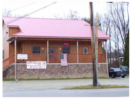
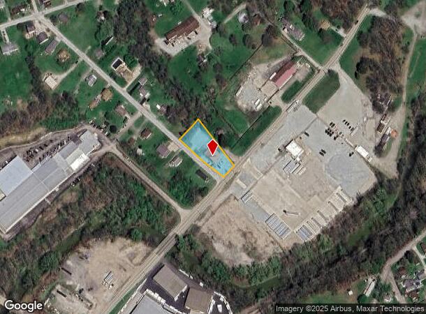
Property Record
1669 New Stanton Ruffsdale Rd, Hunker, PA 15639

NEARBY LISTINGS FOR SALE OR LEASE
Property Detail
1669 New Stanton Ruffsdale Rd
50-40-04-0-035
LOT BLDG (TAVERN) 253 X 115.5 X IR, 1S FR
Commercialnec
Westmoreland
AE
Pennsylvania
42129C0628F
0.67 AC
2024
Westmoreland County
2024
Pittsburgh
804902
Pittsburgh, PA
1,955 SF
DEMOGRAPHICS near 1669 New Stanton Ruffsdale Rd
1 Mile
3 Mile
5 Mile
2024 Total Population
726
7,537
17,229
2029 Population
701
7,333
16,762
Pop Growth 2024-2029
(3.44%)
(2.71%)
(2.71%)
Average Age
44
44
45
2024 Total Households
327
3,382
7,579
HH Growth 2024-2029
(3.36%)
(2.72%)
(2.76%)
Median Household Inc
$67,500
$60,912
$64,166
Avg Household Size
2.20
2.20
2.20
2024 Avg HH Vehicles
2.00
2.00
2.00
Median Home Value
$180,898
$165,761
$174,955
Median Year Built
1973
1972
1970
Nearby Places
- Restaurants
- Banks
- Shops
- Fitness
- Groceries
PUBLIC TRANSPORTATION
COMMUTER RAIL
Greensburg Amtrak (Pennsylvanian - Amtrak)
DRIVE
WALK
Distance
Greensburg Amtrak (Pennsylvanian - Amtrak)
16 min
9.4 mi
AIRPORT
Arnold Palmer Regional
DRIVE
WALK
Distance
Arnold Palmer Regional
31 min
17.6 mi
Freight Ports
Port of Baltimore
DRIVE
WALK
Distance
Port of Baltimore
253 min
217.1 mi
SALE & LEASE HISTORY
LISTING DATE
SALE/LEASE

Sep 23, 2016
For Sale
Nov 20, 2018
For Sale
Nearby Properties
Address
Land Use
TOTAL SIZE
Lot Size
Zoning
Address
Land Use
TOTAL SIZE
Lot Size
Zoning
168.67 AC
Address
Land Use
TOTAL SIZE
Lot Size
Zoning
37.67 AC
Address
Land Use
TOTAL SIZE
Lot Size
Zoning
185.70 AC
Address
Land Use
TOTAL SIZE
Lot Size
Zoning
44.36 AC
Address
Land Use
TOTAL SIZE
Lot Size
Zoning
208,800 SF
31.20 AC
Address
Land Use
TOTAL SIZE
Lot Size
Zoning
32.50 AC
Address
Land Use
TOTAL SIZE
Lot Size
Zoning
Address
Land Use
TOTAL SIZE
Lot Size
Zoning
13.39 AC
Address
Land Use
TOTAL SIZE
Lot Size
Zoning
326,000 SF
109.40 AC
Address
Land Use
TOTAL SIZE
Lot Size
Zoning
35.40 AC
Address
Land Use
TOTAL SIZE
Lot Size
Zoning
57.96 AC
Address
Land Use
TOTAL SIZE
Lot Size
Zoning
342.14 AC
Address
Land Use
TOTAL SIZE
Lot Size
Zoning
11.95 AC
Address
Land Use
TOTAL SIZE
Lot Size
Zoning
57.80 AC
Address
Land Use
TOTAL SIZE
Lot Size
Zoning
Address
Land Use
TOTAL SIZE
Lot Size
Zoning
252,544 SF
22.15 AC
Address
Land Use
TOTAL SIZE
Lot Size
Zoning
9.23 AC
Address
Land Use
TOTAL SIZE
Lot Size
Zoning
8.70 AC
Address
Land Use
TOTAL SIZE
Lot Size
Zoning
204,640 SF
7.76 AC
Address
Land Use
TOTAL SIZE
Lot Size
Zoning
11.22 AC
Address
Land Use
TOTAL SIZE
Lot Size
Zoning
5.10 AC
Address
Land Use
TOTAL SIZE
Lot Size
Zoning
1,924 SF
6.55 AC
Address
Land Use
TOTAL SIZE
Lot Size
Zoning
11.95 AC
Address
Land Use
TOTAL SIZE
Lot Size
Zoning
90,464 SF
21 AC
Address
Land Use
TOTAL SIZE
Lot Size
Zoning
54,542 SF
38.84 AC
Address
Land Use
TOTAL SIZE
Lot Size
Zoning
11.28 AC
Address
Land Use
TOTAL SIZE
Lot Size
Zoning
43,432 SF
4.18 AC
Address
Land Use
TOTAL SIZE
Lot Size
Zoning
3.20 AC
Address
Land Use
TOTAL SIZE
Lot Size
Zoning
5,600 SF
4.41 AC
Address
Land Use
TOTAL SIZE
Lot Size
Zoning
5.20 AC
The World's #1 Commercial Real Estate Marketplace
Connect with us
© 2025 CoStar Group
The information above has been obtained from sources believed reliable. While we do not doubt its accuracy we have not verified it and make no guarantee, warranty or representation about it. It is your responsibility to independently confirm its accuracy and completeness. Any projections, opinions, assumptions, or estimates used are for example only and do not represent the current or future performance of the property. The value of this transaction to you depends on tax and other factors which should be evaluated by your tax, financial, and legal advisors. You and your advisors should conduct a careful, independent investigation of the property to determine to your satisfaction the suitability of the property for your needs.