Property Record
1670 Scenic Hwy N, Snellville, GA 30078
NEARBY LISTINGS FOR SALE OR LEASE
Property Detail
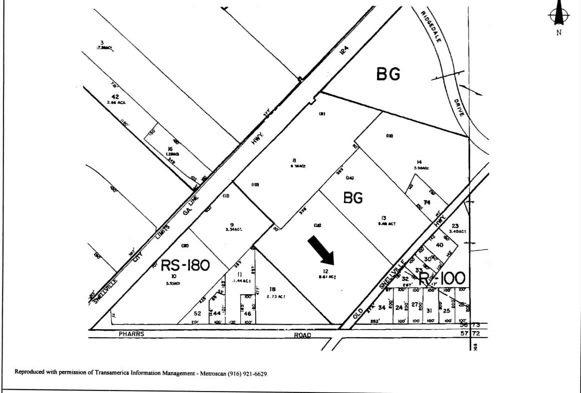
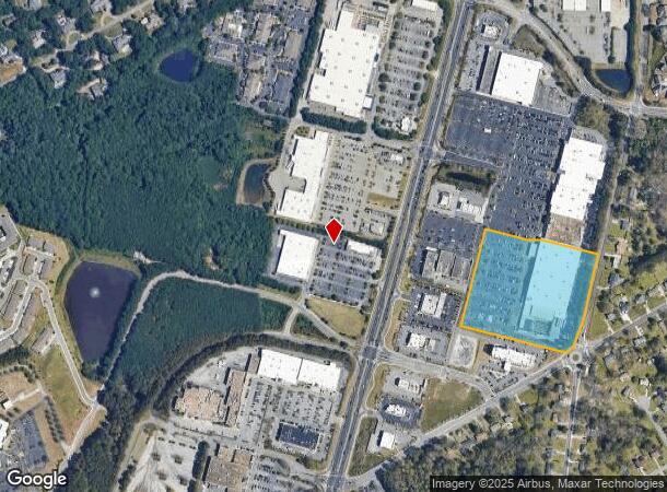
1670 Scenic Hwy N
5-056-012
Ga Hwy 124
Departmentstore
GA HWY 124
X
Gwinnett
13135C0117F
Georgia
2023
9.58 AC
2023
Lawrenceville/Lilburn
050762
Atlanta
103,660 SF
Atlanta-Sandy Springs-Roswell, GA
DEMOGRAPHICS near 1670 Scenic Hwy N
1 Mile
3 Mile
5 Mile
2024 Total Population
6,397
71,366
195,890
2029 Population
6,817
74,775
204,754
Pop Growth 2024-2029
+ 6.57%
+ 4.78%
+ 4.52%
Average Age
41
39
38
2024 Total Households
2,073
23,026
62,719
HH Growth 2024-2029
+ 6.61%
+ 4.86%
+ 4.60%
Median Household Inc
$87,463
$95,247
$86,464
Avg Household Size
3.00
3.00
3.10
2024 Avg HH Vehicles
2.00
2.00
2.00
Median Home Value
$437,747
$321,569
$296,574
Median Year Built
1988
1993
1993
Nearby Places
- Restaurants
- Banks
- Shops
- Fitness
- Groceries
PUBLIC TRANSPORTATION
AIRPORT
Hartsfield - Jackson Atlanta International
DRIVE
WALK
Distance
Hartsfield - Jackson Atlanta International
53 min
34.7 mi
Freight Ports
Georgia Ports - Savannah
DRIVE
WALK
Distance
Georgia Ports - Savannah
306 min
266.6 mi
Nearby Properties
Address
Land Use
TOTAL SIZE
Lot Size
Zoning
Address
Land Use
TOTAL SIZE
Lot Size
Zoning
352,924 SF
86.43 AC
R100
Address
Land Use
TOTAL SIZE
Lot Size
Zoning
242,202 SF
2.05 AC
TC-MU
Address
Land Use
TOTAL SIZE
Lot Size
Zoning
362,674 SF
43.59 AC
CI
Address
Land Use
TOTAL SIZE
Lot Size
Zoning
245,208 SF
15.37 AC
RO
Address
Land Use
TOTAL SIZE
Lot Size
Zoning
280,353 SF
29.36 AC
BG
Address
Land Use
TOTAL SIZE
Lot Size
Zoning
253,355 SF
20.56 AC
RS15
Address
Land Use
TOTAL SIZE
Lot Size
Zoning
84,788 SF
24.09 AC
BG-GENERAL
Address
Land Use
TOTAL SIZE
Lot Size
Zoning
59,949 SF
71.12 AC
C1
Address
Land Use
TOTAL SIZE
Lot Size
Zoning
100,138 SF
18.56 AC
BG-GENERAL
Address
Land Use
TOTAL SIZE
Lot Size
Zoning
148,880 SF
23.15 AC
R100
Address
Land Use
TOTAL SIZE
Lot Size
Zoning
214,399 SF
29.91 AC
C2
Address
Land Use
TOTAL SIZE
Lot Size
Zoning
160,939 SF
25.46 AC
R75-SINGLE
Address
Land Use
TOTAL SIZE
Lot Size
Zoning
454,250 SF
24.30 AC
RS180
Address
Land Use
TOTAL SIZE
Lot Size
Zoning
357,243 SF
59.63 AC
R100
Address
Land Use
TOTAL SIZE
Lot Size
Zoning
218,973 SF
21.04 AC
BG
Address
Land Use
TOTAL SIZE
Lot Size
Zoning
125,097 SF
1.01 AC
CI-CIVIC I
Address
Land Use
TOTAL SIZE
Lot Size
Zoning
123,713 SF
5.97 AC
C2
Address
Land Use
TOTAL SIZE
Lot Size
Zoning
162,000 SF
1.35 AC
OP-OFFICE
Address
Land Use
TOTAL SIZE
Lot Size
Zoning
128,054 SF
15.62 AC
BG
Address
Land Use
TOTAL SIZE
Lot Size
Zoning
108,123 SF
13.96 AC
R100
Address
Land Use
TOTAL SIZE
Lot Size
Zoning
104,989 SF
9.71 AC
CI
Address
Land Use
TOTAL SIZE
Lot Size
Zoning
118,804 SF
17.66 AC
C2
Address
Land Use
TOTAL SIZE
Lot Size
Zoning
146,587 SF
13.91 AC
BG
Address
Land Use
TOTAL SIZE
Lot Size
Zoning
93,046 SF
82 AC
R100
Address
Land Use
TOTAL SIZE
Lot Size
Zoning
131,121 SF
12.99 AC
BG
Address
Land Use
TOTAL SIZE
Lot Size
Zoning
49,278 SF
8.28 AC
R100
Address
Land Use
TOTAL SIZE
Lot Size
Zoning
85,810 SF
11.32 AC
BG
Address
Land Use
TOTAL SIZE
Lot Size
Zoning
75,354 SF
8.30 AC
HSB-HIGHWA
Address
Land Use
TOTAL SIZE
Lot Size
Zoning
52,288 SF
4.85 AC
C2
Address
Land Use
TOTAL SIZE
Lot Size
Zoning
51,704 SF
17.25 AC
OI
The World's #1 Commercial Real Estate Marketplace
Connect with us
© 2025 CoStar Group
The information above has been obtained from sources believed reliable. While we do not doubt its accuracy we have not verified it and make no guarantee, warranty or representation about it. It is your responsibility to independently confirm its accuracy and completeness. Any projections, opinions, assumptions, or estimates used are for example only and do not represent the current or future performance of the property. The value of this transaction to you depends on tax and other factors which should be evaluated by your tax, financial, and legal advisors. You and your advisors should conduct a careful, independent investigation of the property to determine to your satisfaction the suitability of the property for your needs.