Property Record
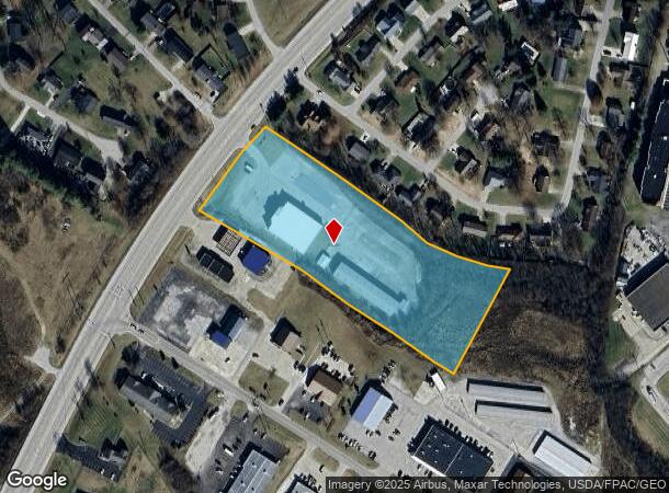
1684 Us Highway 68, Maysville, KY 41056
NEARBY LISTINGS FOR SALE OR LEASE
Property Detail
1684 Us Highway 68
050-00-00-007.03
Us 68
Commercialnec
5.0047 AC LOT & CHURCH & BUILDINGS
X
Mason
21161C0093E
Kentucky
2023
5 AC
2023
Kentucky East Area
960300
Other Market Areas
12,000 SF
Maysville, KY
DEMOGRAPHICS near 1684 Us Highway 68
1 Mile
3 Mile
5 Mile
2024 Total Population
1,001
7,932
13,212
2029 Population
983
7,923
13,202
Pop Growth 2024-2029
(1.80%)
(0.11%)
(0.08%)
Average Age
44
43
42
2024 Total Households
418
3,427
5,772
HH Growth 2024-2029
(1.67%)
(0.06%)
(0.02%)
Median Household Inc
$52,639
$52,180
$42,680
Avg Household Size
2.20
2.20
2.20
2024 Avg HH Vehicles
2.00
2.00
2.00
Median Home Value
$186,666
$172,861
$154,545
Median Year Built
1979
1972
1970
Nearby Places
- Restaurants
- Banks
- Shops
- Fitness
- Groceries
PUBLIC TRANSPORTATION
COMMUTER RAIL
Maysville Amtrak Station (Cardinal - Amtrak)
Drive
Walk
Distance
Maysville Amtrak Station (Cardinal - Amtrak)
6 min
2.9 mi
Freight Ports
Port of Toledo
Drive
Walk
Distance
Port of Toledo
321 min
261.3 mi
SALE & LEASE HISTORY
LISTING DATE
SALE/LEASE

Jan 04, 2017
For Sale
Nearby Properties
Address
Land Use
TOTAL SIZE
Lot Size
Zoning
Address
Land Use
TOTAL SIZE
Lot Size
Zoning
112554
119.46 AC
Address
Land Use
TOTAL SIZE
Lot Size
Zoning
1400
21.45 AC
Address
Land Use
TOTAL SIZE
Lot Size
Zoning
49.51 AC
Address
Land Use
TOTAL SIZE
Lot Size
Zoning
95360
24.02 AC
Address
Land Use
TOTAL SIZE
Lot Size
Zoning
25.41 AC
Address
Land Use
TOTAL SIZE
Lot Size
Zoning
207498
26.60 AC
Address
Land Use
TOTAL SIZE
Lot Size
Zoning
14025
23.58 AC
Address
Land Use
TOTAL SIZE
Lot Size
Zoning
226418
14.29 AC
Address
Land Use
TOTAL SIZE
Lot Size
Zoning
Address
Land Use
TOTAL SIZE
Lot Size
Zoning
111196
27.57 AC
Address
Land Use
TOTAL SIZE
Lot Size
Zoning
7.25 AC
Address
Land Use
TOTAL SIZE
Lot Size
Zoning
38000
5.66 AC
Address
Land Use
TOTAL SIZE
Lot Size
Zoning
13076
0.55 AC
Address
Land Use
TOTAL SIZE
Lot Size
Zoning
32200
9.34 AC
Address
Land Use
TOTAL SIZE
Lot Size
Zoning
25200
0.11 AC
Address
Land Use
TOTAL SIZE
Lot Size
Zoning
91173
9.57 AC
Address
Land Use
TOTAL SIZE
Lot Size
Zoning
121240
9.20 AC
Address
Land Use
TOTAL SIZE
Lot Size
Zoning
384
2.76 AC
Address
Land Use
TOTAL SIZE
Lot Size
Zoning
26000
0.27 AC
COMMERCIAL
Address
Land Use
TOTAL SIZE
Lot Size
Zoning
55166
2.45 AC
Address
Land Use
TOTAL SIZE
Lot Size
Zoning
0.54 AC
Address
Land Use
TOTAL SIZE
Lot Size
Zoning
5568
0.39 AC
Address
Land Use
TOTAL SIZE
Lot Size
Zoning
27.77 AC
Address
Land Use
TOTAL SIZE
Lot Size
Zoning
62848
78.29 AC
Address
Land Use
TOTAL SIZE
Lot Size
Zoning
29716
24.19 AC
Address
Land Use
TOTAL SIZE
Lot Size
Zoning
Address
Land Use
TOTAL SIZE
Lot Size
Zoning
31828
6.39 AC
Address
Land Use
TOTAL SIZE
Lot Size
Zoning
27075
0.08 AC
Address
Land Use
TOTAL SIZE
Lot Size
Zoning
84725
5.43 AC
Address
Land Use
TOTAL SIZE
Lot Size
Zoning
12778
53 AC
Start a new search to find other properties for sale or lease
Connect with us
© 2024 CoStar Group
The information above has been obtained from sources believed reliable. While we do not doubt its accuracy we have not verified it and make no guarantee, warranty or representation about it. It is your responsibility to independently confirm its accuracy and completeness. Any projections, opinions, assumptions, or estimates used are for example only and do not represent the current or future performance of the property. The value of this transaction to you depends on tax and other factors which should be evaluated by your tax, financial, and legal advisors. You and your advisors should conduct a careful, independent investigation of the property to determine to your satisfaction the suitability of the property for your needs.