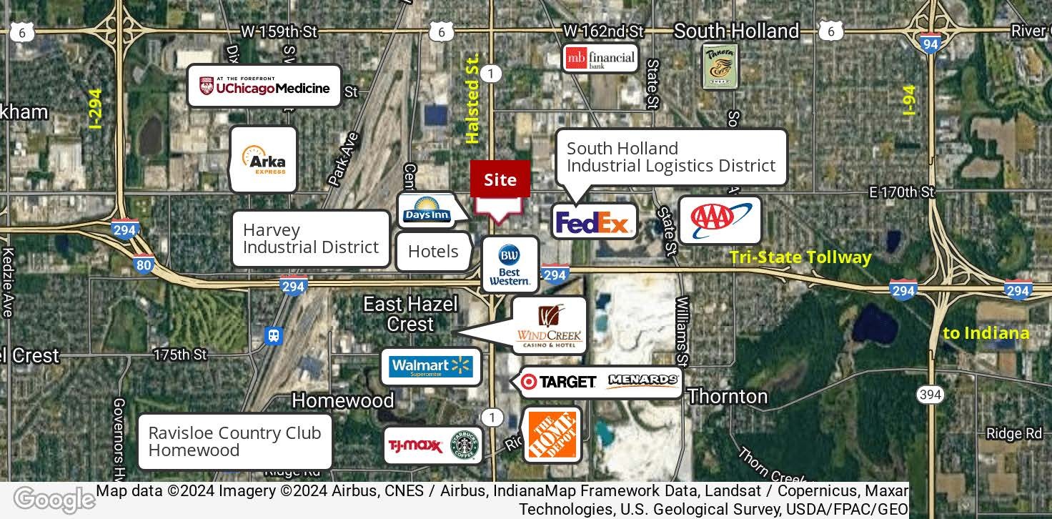
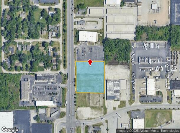
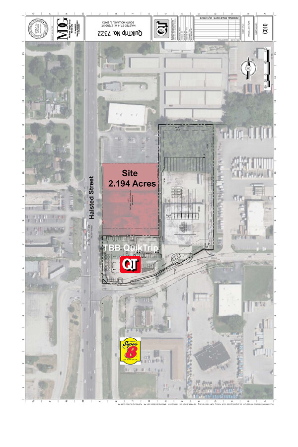
Property Record
16855 Halsted St, South Holland, IL 60473
NEARBY LISTINGS FOR SALE OR LEASE
-
-
-
No Photo
-
-
View all South Holland listings for sale on LoopNet.com
Property Detail
16855 Halsted St
Chicago-Naperville-Elgin, IL-IN-WI
Gateway South/Harvey
29-28-100-108-0000
Cook
Vacantlandnec
Illinois
X
1
17031C0734J
2.02 AC
2022
Near South Cook
2024
Chicago
827801
DEMOGRAPHICS near 16855 Halsted St
1 Mile
3 Mile
5 Mile
2024 Total Population
2,592
80,707
230,940
2029 Population
2,534
79,556
226,610
Pop Growth 2024-2029
(2.24%)
(1.43%)
(1.87%)
Average Age
39
41
40
2024 Total Households
923
29,283
84,316
HH Growth 2024-2029
(2.49%)
(1.72%)
(2.20%)
Median Household Inc
$55,000
$55,670
$57,121
Avg Household Size
2.80
2.70
2.60
2024 Avg HH Vehicles
2.00
2.00
2.00
Median Home Value
$99,140
$139,791
$144,998
Median Year Built
1958
1962
1965
Nearby Places
- Restaurants
- Banks
- Shops
- Fitness
- Groceries
PUBLIC TRANSPORTATION
COMMUTER RAIL
Hazel Crest Station (Metra Electric Line - Northeast Illinois Regional Commuter Railroad (Metra))
DRIVE
WALK
Distance
Hazel Crest Station (Metra Electric Line - Northeast Illinois Regional Commuter Railroad (Metra))
4 min
1.6 mi
Calumet Station (Metra Electric Line - Northeast Illinois Regional Commuter Railroad (Metra))
DRIVE
WALK
Distance
Calumet Station (Metra Electric Line - Northeast Illinois Regional Commuter Railroad (Metra))
5 min
2.0 mi
AIRPORT
Chicago Midway International
DRIVE
WALK
Distance
Chicago Midway International
29 min
19.2 mi
Freight Ports
Port Milwaukee
DRIVE
WALK
Distance
Port Milwaukee
135 min
112.7 mi
Nearby Properties
Address
Land Use
TOTAL SIZE
Lot Size
Zoning
Address
Land Use
TOTAL SIZE
Lot Size
Zoning
Address
Land Use
TOTAL SIZE
Lot Size
Zoning
1.45 AC
Address
Land Use
TOTAL SIZE
Lot Size
Zoning
6.19 AC
Address
Land Use
TOTAL SIZE
Lot Size
Zoning
244,665 SF
9.05 AC
Address
Land Use
TOTAL SIZE
Lot Size
Zoning
4.85 AC
Address
Land Use
TOTAL SIZE
Lot Size
Zoning
78,884 SF
5.60 AC
Address
Land Use
TOTAL SIZE
Lot Size
Zoning
60,864 SF
5.55 AC
Address
Land Use
TOTAL SIZE
Lot Size
Zoning
231,296 SF
10.91 AC
Address
Land Use
TOTAL SIZE
Lot Size
Zoning
196,125 SF
18.55 AC
Address
Land Use
TOTAL SIZE
Lot Size
Zoning
2.86 AC
Address
Land Use
TOTAL SIZE
Lot Size
Zoning
52,220 SF
6 AC
Address
Land Use
TOTAL SIZE
Lot Size
Zoning
125,535 SF
9.44 AC
Address
Land Use
TOTAL SIZE
Lot Size
Zoning
Address
Land Use
TOTAL SIZE
Lot Size
Zoning
Address
Land Use
TOTAL SIZE
Lot Size
Zoning
27,082 SF
0.69 AC
Address
Land Use
TOTAL SIZE
Lot Size
Zoning
44,189 SF
3.09 AC
Address
Land Use
TOTAL SIZE
Lot Size
Zoning
49,229 SF
1.31 AC
Address
Land Use
TOTAL SIZE
Lot Size
Zoning
180,139 SF
18.78 AC
Address
Land Use
TOTAL SIZE
Lot Size
Zoning
197,001 SF
22.75 AC
Address
Land Use
TOTAL SIZE
Lot Size
Zoning
38,111 SF
6.70 AC
Address
Land Use
TOTAL SIZE
Lot Size
Zoning
Address
Land Use
TOTAL SIZE
Lot Size
Zoning
115,250 SF
10.75 AC
Address
Land Use
TOTAL SIZE
Lot Size
Zoning
111,902 SF
8.60 AC
Address
Land Use
TOTAL SIZE
Lot Size
Zoning
233,490 SF
10.19 AC
Address
Land Use
TOTAL SIZE
Lot Size
Zoning
6.21 AC
Address
Land Use
TOTAL SIZE
Lot Size
Zoning
6.34 AC
Address
Land Use
TOTAL SIZE
Lot Size
Zoning
Address
Land Use
TOTAL SIZE
Lot Size
Zoning
0.34 AC
Address
Land Use
TOTAL SIZE
Lot Size
Zoning
5.42 AC
Address
Land Use
TOTAL SIZE
Lot Size
Zoning
The World's #1 Commercial Real Estate Marketplace
Connect with us
© 2025 CoStar Group
The information above has been obtained from sources believed reliable. While we do not doubt its accuracy we have not verified it and make no guarantee, warranty or representation about it. It is your responsibility to independently confirm its accuracy and completeness. Any projections, opinions, assumptions, or estimates used are for example only and do not represent the current or future performance of the property. The value of this transaction to you depends on tax and other factors which should be evaluated by your tax, financial, and legal advisors. You and your advisors should conduct a careful, independent investigation of the property to determine to your satisfaction the suitability of the property for your needs.