Property Record
16930 State Route 507 Se, Yelm, WA 98597
NEARBY LISTINGS FOR SALE OR LEASE
Property Detail
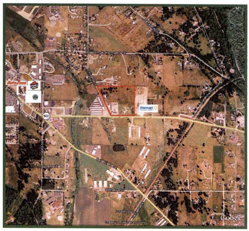
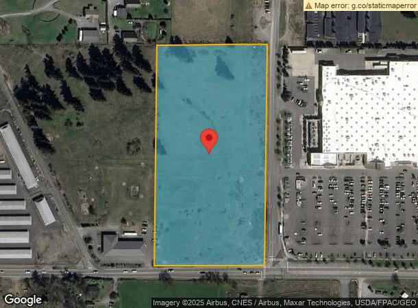
16930 State Route 507 Se
Olympia-Tumwater, WA
Mckenna Irrigated Tracts
64303100900
SECTION 29 TOWNSHIP 17 RANGE 2E PLAT MCKENNA IRRIGATED TRACTS BLK 31 LT 9 DOCUMENT 009/044 EX S 10F STATE HWY 5-H LESS ROW 4911071
Vacantlandnec
Thurston
X
Washington
53067C0362F
9
2024
7.12 AC
2024
Yelm/N Yelm
012412
Olympia
DEMOGRAPHICS near 16930 State Route 507 Se
1 Mile
3 Mile
5 Mile
2024 Total Population
2,919
18,114
25,003
2029 Population
3,031
18,891
25,927
Pop Growth 2024-2029
+ 3.84%
+ 4.29%
+ 3.70%
Average Age
35
37
38
2024 Total Households
991
5,991
8,425
HH Growth 2024-2029
+ 3.94%
+ 4.29%
+ 3.67%
Median Household Inc
$87,859
$82,718
$84,443
Avg Household Size
2.90
3.00
2.90
2024 Avg HH Vehicles
3.00
2.00
2.00
Median Home Value
$358,076
$371,333
$402,246
Median Year Built
1999
1995
1994
Nearby Places
- Restaurants
- Banks
- Shops
- Fitness
- Groceries
SALE & LEASE HISTORY
LISTING DATE
SALE/LEASE

Sep 24, 2016
For Sale
Jul 12, 2023
For Lease
Jul 12, 2023
For Sale
Nearby Properties
Address
Land Use
TOTAL SIZE
Lot Size
Zoning
Address
Land Use
TOTAL SIZE
Lot Size
Zoning
172,555 SF
36.60 AC
ID
Address
Land Use
TOTAL SIZE
Lot Size
Zoning
168,571 SF
9.34 AC
C-1
Address
Land Use
TOTAL SIZE
Lot Size
Zoning
191,444 SF
15.03 AC
C-3
Address
Land Use
TOTAL SIZE
Lot Size
Zoning
72,563 SF
7.35 AC
ID
Address
Land Use
TOTAL SIZE
Lot Size
Zoning
92,450 SF
4.31 AC
R-14
Address
Land Use
TOTAL SIZE
Lot Size
Zoning
55,078 SF
29.99 AC
ID
Address
Land Use
TOTAL SIZE
Lot Size
Zoning
44,133 SF
23.12 AC
ID
Address
Land Use
TOTAL SIZE
Lot Size
Zoning
49,446 SF
12.08 AC
C-1
Address
Land Use
TOTAL SIZE
Lot Size
Zoning
80,984 SF
4.99 AC
R-14
Address
Land Use
TOTAL SIZE
Lot Size
Zoning
36,903 SF
19.55 AC
RR1/5
Address
Land Use
TOTAL SIZE
Lot Size
Zoning
55,482 SF
4.27 AC
Address
Land Use
TOTAL SIZE
Lot Size
Zoning
81,291 SF
2.66 AC
C-1
Address
Land Use
TOTAL SIZE
Lot Size
Zoning
65,439 SF
4.96 AC
C-1
Address
Land Use
TOTAL SIZE
Lot Size
Zoning
56,040 SF
6.64 AC
C-1
Address
Land Use
TOTAL SIZE
Lot Size
Zoning
83,376 SF
1.36 AC
C-1
Address
Land Use
TOTAL SIZE
Lot Size
Zoning
34,688 SF
3.54 AC
C-1
Address
Land Use
TOTAL SIZE
Lot Size
Zoning
44,156 SF
9 AC
RAC
Address
Land Use
TOTAL SIZE
Lot Size
Zoning
35,506 SF
1.70 AC
MPC
Address
Land Use
TOTAL SIZE
Lot Size
Zoning
44,131 SF
5 AC
RRR1/5
Address
Land Use
TOTAL SIZE
Lot Size
Zoning
51,917 SF
4.83 AC
C-1
Address
Land Use
TOTAL SIZE
Lot Size
Zoning
68,044 SF
3.82 AC
C-1
Address
Land Use
TOTAL SIZE
Lot Size
Zoning
42,750 SF
5.04 AC
MPC
Address
Land Use
TOTAL SIZE
Lot Size
Zoning
39,559 SF
2.52 AC
C-1
Address
Land Use
TOTAL SIZE
Lot Size
Zoning
9,076 SF
11.95 AC
I
Address
Land Use
TOTAL SIZE
Lot Size
Zoning
59,480 SF
5 AC
C-3
Address
Land Use
TOTAL SIZE
Lot Size
Zoning
28,992 SF
3.09 AC
C-2
Address
Land Use
TOTAL SIZE
Lot Size
Zoning
38,409 SF
1.81 AC
C-1
Address
Land Use
TOTAL SIZE
Lot Size
Zoning
19,505 SF
0.34 AC
CBD
Address
Land Use
TOTAL SIZE
Lot Size
Zoning
22,467 SF
1.81 AC
C-1
Address
Land Use
TOTAL SIZE
Lot Size
Zoning
28,330 SF
2.38 AC
R-14
The World's #1 Commercial Real Estate Marketplace
Connect with us
© 2025 CoStar Group
The information above has been obtained from sources believed reliable. While we do not doubt its accuracy we have not verified it and make no guarantee, warranty or representation about it. It is your responsibility to independently confirm its accuracy and completeness. Any projections, opinions, assumptions, or estimates used are for example only and do not represent the current or future performance of the property. The value of this transaction to you depends on tax and other factors which should be evaluated by your tax, financial, and legal advisors. You and your advisors should conduct a careful, independent investigation of the property to determine to your satisfaction the suitability of the property for your needs.