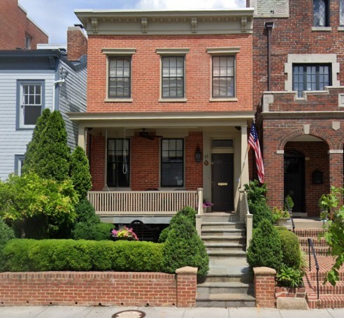
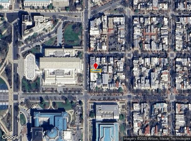
Property Record
17 2Nd St Ne, Washington, DC 20002

NEARBY LISTINGS FOR SALE OR LEASE
Property Detail
17 2Nd St Ne
Washington-Arlington-Alexandria, DC-VA-MD-WV
Capitol Hill
0759-0042
SQUARE 0759 LOT 0042 NBHD: CAPITOL HILL
Commercialnec
District of Columbia
X
District of Columbia
1100010019C
42
2024
0.05 AC
2024
Capitol Hill
008200
Washington, DC
2,743 SF
DEMOGRAPHICS near 17 2Nd St Ne
1 Mile
3 Mile
5 Mile
2024 Total Population
53,792
321,035
750,669
2029 Population
49,986
296,824
699,421
Pop Growth 2024-2029
(7.08%)
(7.54%)
(6.83%)
Average Age
36
36
37
2024 Total Households
28,337
160,079
351,139
HH Growth 2024-2029
(7.53%)
(8.39%)
(7.46%)
Median Household Inc
$140,742
$97,830
$92,062
Avg Household Size
1.80
1.90
2.00
2024 Avg HH Vehicles
1.00
1.00
1.00
Median Home Value
$834,695
$691,080
$617,383
Median Year Built
1986
1966
1963
Nearby Places
- Restaurants
- Banks
- Shops
- Fitness
- Groceries
PUBLIC TRANSPORTATION
TRANSIT/SUBWAY
Capitol South (Blue Line - Washington Metropolitan Area Transit Authority Metrorail (Metrorail), Orange Line - Washington Metropolitan Area Transit Authority Metrorail (Metrorail), Silver Line - Washington Metropolitan Area Transit Authority Metrorail (Metrorail))
DRIVE
WALK
Distance
Capitol South (Blue Line - Washington Metropolitan Area Transit Authority Metrorail (Metrorail), Orange Line - Washington Metropolitan Area Transit Authority Metrorail (Metrorail), Silver Line - Washington Metropolitan Area Transit Authority Metrorail (Metrorail))
2 min
11 min
0.6 mi
Eastern Market (Blue Line - Washington Metropolitan Area Transit Authority Metrorail (Metrorail), Orange Line - Washington Metropolitan Area Transit Authority Metrorail (Metrorail), Silver Line - Washington Metropolitan Area Transit Authority Metrorail (Metrorail))
DRIVE
WALK
Distance
Eastern Market (Blue Line - Washington Metropolitan Area Transit Authority Metrorail (Metrorail), Orange Line - Washington Metropolitan Area Transit Authority Metrorail (Metrorail), Silver Line - Washington Metropolitan Area Transit Authority Metrorail (Metrorail))
2 min
14 min
0.7 mi
Federal Center Sw (Blue Line - Washington Metropolitan Area Transit Authority Metrorail (Metrorail), Orange Line - Washington Metropolitan Area Transit Authority Metrorail (Metrorail), Silver Line - Washington Metropolitan Area Transit Authority Metrorail (Metrorail))
DRIVE
WALK
Distance
Federal Center Sw (Blue Line - Washington Metropolitan Area Transit Authority Metrorail (Metrorail), Orange Line - Washington Metropolitan Area Transit Authority Metrorail (Metrorail), Silver Line - Washington Metropolitan Area Transit Authority Metrorail (Metrorail))
3 min
20 min
1.1 mi
COMMUTER RAIL
Union Station (Brunswick Line - Maryland Area Regional Commuter Trains (The MARC), Camden Line - Maryland Area Regional Commuter Trains (The MARC), Fredericksburg Line - Maryland Area Regional Commuter Trains (The MARC), Manassas Line - Maryland Area Regional Commuter Trains (The MARC), Penn Line - Maryland Area Regional Commuter Trains (The MARC), Red Line - Maryland Area Regional Commuter Trains (The MARC))
DRIVE
WALK
Distance
Union Station (Brunswick Line - Maryland Area Regional Commuter Trains (The MARC), Camden Line - Maryland Area Regional Commuter Trains (The MARC), Fredericksburg Line - Maryland Area Regional Commuter Trains (The MARC), Manassas Line - Maryland Area Regional Commuter Trains (The MARC), Penn Line - Maryland Area Regional Commuter Trains (The MARC), Red Line - Maryland Area Regional Commuter Trains (The MARC))
3 min
12 min
0.7 mi
L'enfant (Fredericksburg Line - Virginia Railway Express, Manassas Line - Virginia Railway Express)
DRIVE
WALK
Distance
L'enfant (Fredericksburg Line - Virginia Railway Express, Manassas Line - Virginia Railway Express)
3 min
1.5 mi
AIRPORT
Ronald Reagan Washington Ntl
DRIVE
WALK
Distance
Ronald Reagan Washington Ntl
11 min
5.8 mi
Washington Dulles International
DRIVE
WALK
Distance
Washington Dulles International
47 min
29.5 mi
Baltimore/Washington International Thurgood Marshall
DRIVE
WALK
Distance
Baltimore/Washington International Thurgood Marshall
45 min
30.7 mi
Freight Ports
Port of Baltimore
DRIVE
WALK
Distance
Port of Baltimore
55 min
37.3 mi
SALE & LEASE HISTORY
LISTING DATE
SALE/LEASE

Oct 01, 2024
For Sale
Jun 14, 2023
For Sale
Nearby Properties
Address
Land Use
TOTAL SIZE
Lot Size
Zoning
Address
Land Use
TOTAL SIZE
Lot Size
Zoning
2,300,000 SF
1.60 AC
D-5-R
Address
Land Use
TOTAL SIZE
Lot Size
Zoning
187,127 SF
90.60 AC
UNZONED
Address
Land Use
TOTAL SIZE
Lot Size
Zoning
40,980 SF
373.22 AC
UNZONED
Address
Land Use
TOTAL SIZE
Lot Size
Zoning
1,121 SF
88.76 AC
GOV
Address
Land Use
TOTAL SIZE
Lot Size
Zoning
443,830 SF
70.25 AC
UNZONED
Address
Land Use
TOTAL SIZE
Lot Size
Zoning
142 AC
GOV
Address
Land Use
TOTAL SIZE
Lot Size
Zoning
533,778 SF
18.08 AC
UNZONED
Address
Land Use
TOTAL SIZE
Lot Size
Zoning
1,290,186 SF
8.99 AC
UNZONED
Address
Land Use
TOTAL SIZE
Lot Size
Zoning
3.71 AC
UNZONED
Address
Land Use
TOTAL SIZE
Lot Size
Zoning
63.89 AC
GOV
Address
Land Use
TOTAL SIZE
Lot Size
Zoning
19.46 AC
CG-4
Address
Land Use
TOTAL SIZE
Lot Size
Zoning
418.97 AC
MU-4,UNZON
Address
Land Use
TOTAL SIZE
Lot Size
Zoning
1,170,529 SF
10.82 AC
UNZONED
Address
Land Use
TOTAL SIZE
Lot Size
Zoning
262,673 SF
5.34 AC
D-7
Address
Land Use
TOTAL SIZE
Lot Size
Zoning
1,530,865 SF
6.04 AC
D-6,UNZONE
Address
Land Use
TOTAL SIZE
Lot Size
Zoning
6,500,000 SF
0.20 AC
S-3A
Address
Land Use
TOTAL SIZE
Lot Size
Zoning
2,369,428 SF
7.93 AC
MU-10,SEFC
Address
Land Use
TOTAL SIZE
Lot Size
Zoning
42.57 AC
GOV
Address
Land Use
TOTAL SIZE
Lot Size
Zoning
52.44 AC
UNZONED
Address
Land Use
TOTAL SIZE
Lot Size
Zoning
1,100,000 SF
2.13 AC
D-6
Address
Land Use
TOTAL SIZE
Lot Size
Zoning
1,336,013 SF
5.41 AC
D-5
Address
Land Use
TOTAL SIZE
Lot Size
Zoning
1,310,661 SF
3.38 AC
D-6
Address
Land Use
TOTAL SIZE
Lot Size
Zoning
2,455,000 SF
11.08 AC
MU-2
Address
Land Use
TOTAL SIZE
Lot Size
Zoning
1,545,768 SF
2.11 AC
D-7
Address
Land Use
TOTAL SIZE
Lot Size
Zoning
185,826 SF
9.40 AC
UNZONED
Address
Land Use
TOTAL SIZE
Lot Size
Zoning
130,083 SF
6.46 AC
UNZONED
Address
Land Use
TOTAL SIZE
Lot Size
Zoning
1,043,058 SF
4.03 AC
UNZONED
Address
Land Use
TOTAL SIZE
Lot Size
Zoning
1.57 AC
D-5
Address
Land Use
TOTAL SIZE
Lot Size
Zoning
2,058,692 SF
4.77 AC
UNZONED
Address
Land Use
TOTAL SIZE
Lot Size
Zoning
1,015,833 SF
1.60 AC
D-7
The World's #1 Commercial Real Estate Marketplace
Connect with us
© 2025 CoStar Group
The information above has been obtained from sources believed reliable. While we do not doubt its accuracy we have not verified it and make no guarantee, warranty or representation about it. It is your responsibility to independently confirm its accuracy and completeness. Any projections, opinions, assumptions, or estimates used are for example only and do not represent the current or future performance of the property. The value of this transaction to you depends on tax and other factors which should be evaluated by your tax, financial, and legal advisors. You and your advisors should conduct a careful, independent investigation of the property to determine to your satisfaction the suitability of the property for your needs.