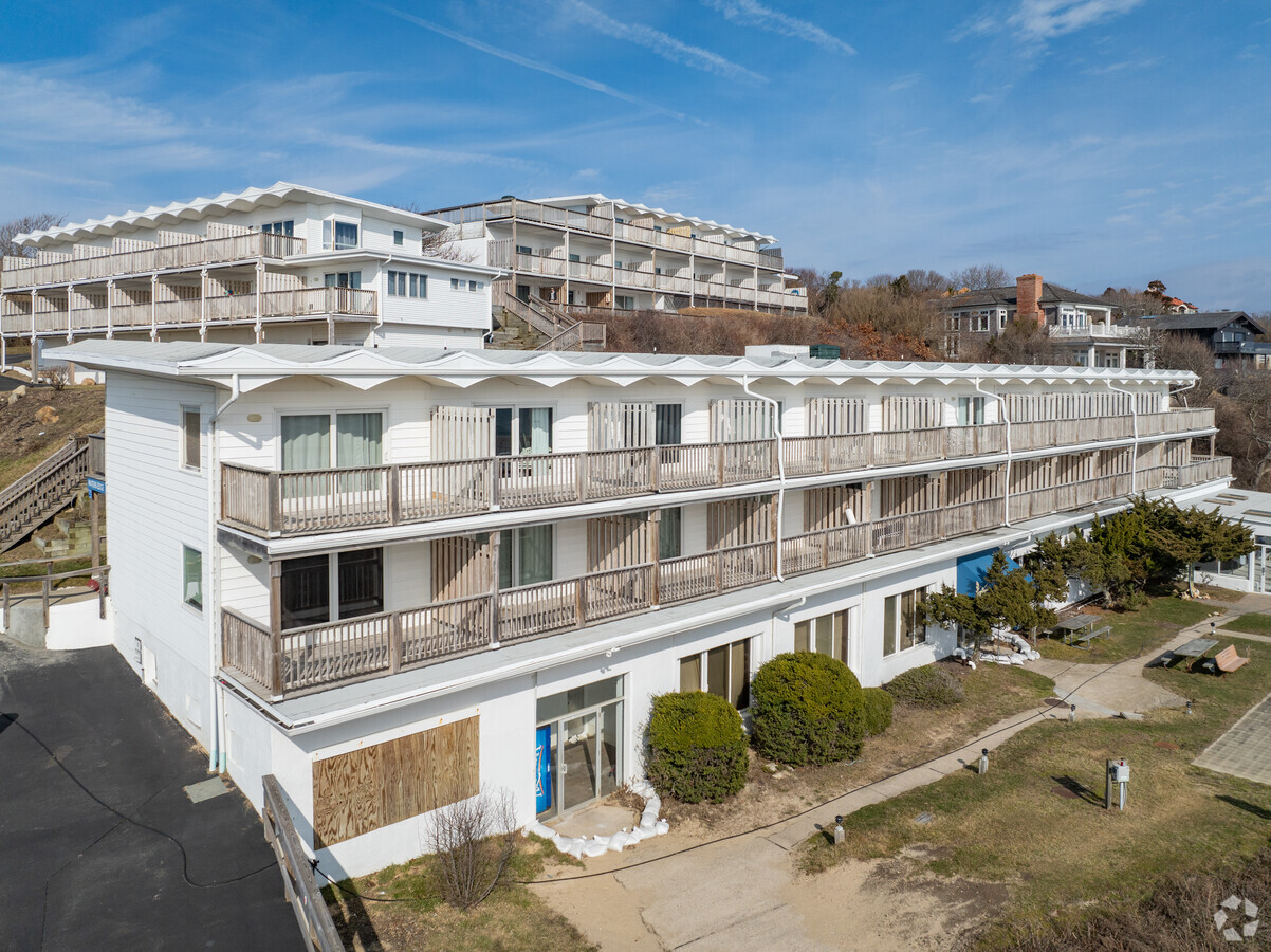
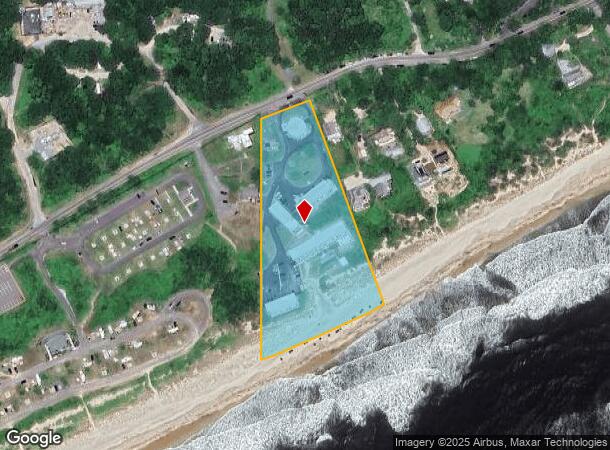
Property Record
170 Old Montauk Hwy, Montauk, NY 11954

NEARBY LISTINGS FOR SALE OR LEASE
-
-
View all Montauk listings for sale on LoopNet.com
Property Detail
170 Old Montauk Hwy
Nassau County-Suffolk County, NY
MTK HWY MATSON/ANDRADE ATLANTIC OC HITHER HL ST PKTC-235
0300-087-00-03-00-027-000
Suffolk
Transientlodging
New York
VE
27
36103C0244H
3.48 AC
2023
Suffolk
2023
Long Island (New York)
201007
DEMOGRAPHICS near 170 Old Montauk Hwy
1 Mile
3 Mile
5 Mile
2024 Total Population
162
1,615
5,562
2029 Population
175
1,711
5,898
Pop Growth 2024-2029
+ 8.02%
+ 5.94%
+ 6.04%
Average Age
47
47
46
2024 Total Households
69
688
2,326
HH Growth 2024-2029
+ 8.70%
+ 5.96%
+ 5.93%
Median Household Inc
$157,954
$154,774
$144,601
Avg Household Size
2.30
2.30
2.30
2024 Avg HH Vehicles
2.00
2.00
2.00
Median Home Value
$1,106,667
$1,099,286
$1,024,695
Median Year Built
1981
1980
1980
Nearby Places
- Restaurants
- Banks
- Shops
- Fitness
- Groceries
PUBLIC TRANSPORTATION
COMMUTER RAIL
Montauk Station (Montauk Branch - Long Island Rail Road)
DRIVE
WALK
Distance
Montauk Station (Montauk Branch - Long Island Rail Road)
13 min
6.5 mi
Amagansett Station (Montauk Branch - Long Island Rail Road)
DRIVE
WALK
Distance
Amagansett Station (Montauk Branch - Long Island Rail Road)
12 min
7.3 mi
Freight Ports
Port of New Haven
DRIVE
WALK
Distance
Port of New Haven
217 min
99.5 mi
Nearby Properties
Address
Land Use
TOTAL SIZE
Lot Size
Zoning
Address
Land Use
TOTAL SIZE
Lot Size
Zoning
10.61 AC
Address
Land Use
TOTAL SIZE
Lot Size
Zoning
Address
Land Use
TOTAL SIZE
Lot Size
Zoning
10.30 AC
Address
Land Use
TOTAL SIZE
Lot Size
Zoning
37.70 AC
Address
Land Use
TOTAL SIZE
Lot Size
Zoning
Address
Land Use
TOTAL SIZE
Lot Size
Zoning
40.49 AC
Address
Land Use
TOTAL SIZE
Lot Size
Zoning
9.30 AC
Address
Land Use
TOTAL SIZE
Lot Size
Zoning
2.01 AC
Address
Land Use
TOTAL SIZE
Lot Size
Zoning
3.60 AC
Address
Land Use
TOTAL SIZE
Lot Size
Zoning
7.35 AC
Address
Land Use
TOTAL SIZE
Lot Size
Zoning
0.89 AC
Address
Land Use
TOTAL SIZE
Lot Size
Zoning
8.87 AC
Address
Land Use
TOTAL SIZE
Lot Size
Zoning
2.64 AC
Address
Land Use
TOTAL SIZE
Lot Size
Zoning
Address
Land Use
TOTAL SIZE
Lot Size
Zoning
3.23 AC
Address
Land Use
TOTAL SIZE
Lot Size
Zoning
8.28 AC
Address
Land Use
TOTAL SIZE
Lot Size
Zoning
0.56 AC
Address
Land Use
TOTAL SIZE
Lot Size
Zoning
Address
Land Use
TOTAL SIZE
Lot Size
Zoning
0.28 AC
Address
Land Use
TOTAL SIZE
Lot Size
Zoning
1.10 AC
Address
Land Use
TOTAL SIZE
Lot Size
Zoning
19.80 AC
Address
Land Use
TOTAL SIZE
Lot Size
Zoning
4.73 AC
Address
Land Use
TOTAL SIZE
Lot Size
Zoning
1.04 AC
Address
Land Use
TOTAL SIZE
Lot Size
Zoning
Address
Land Use
TOTAL SIZE
Lot Size
Zoning
33.66 AC
Address
Land Use
TOTAL SIZE
Lot Size
Zoning
1.29 AC
Address
Land Use
TOTAL SIZE
Lot Size
Zoning
0.76 AC
Address
Land Use
TOTAL SIZE
Lot Size
Zoning
0.55 AC
Address
Land Use
TOTAL SIZE
Lot Size
Zoning
0.35 AC
Address
Land Use
TOTAL SIZE
Lot Size
Zoning
0.69 AC
The World's #1 Commercial Real Estate Marketplace
Connect with us
© 2025 CoStar Group
The information above has been obtained from sources believed reliable. While we do not doubt its accuracy we have not verified it and make no guarantee, warranty or representation about it. It is your responsibility to independently confirm its accuracy and completeness. Any projections, opinions, assumptions, or estimates used are for example only and do not represent the current or future performance of the property. The value of this transaction to you depends on tax and other factors which should be evaluated by your tax, financial, and legal advisors. You and your advisors should conduct a careful, independent investigation of the property to determine to your satisfaction the suitability of the property for your needs.