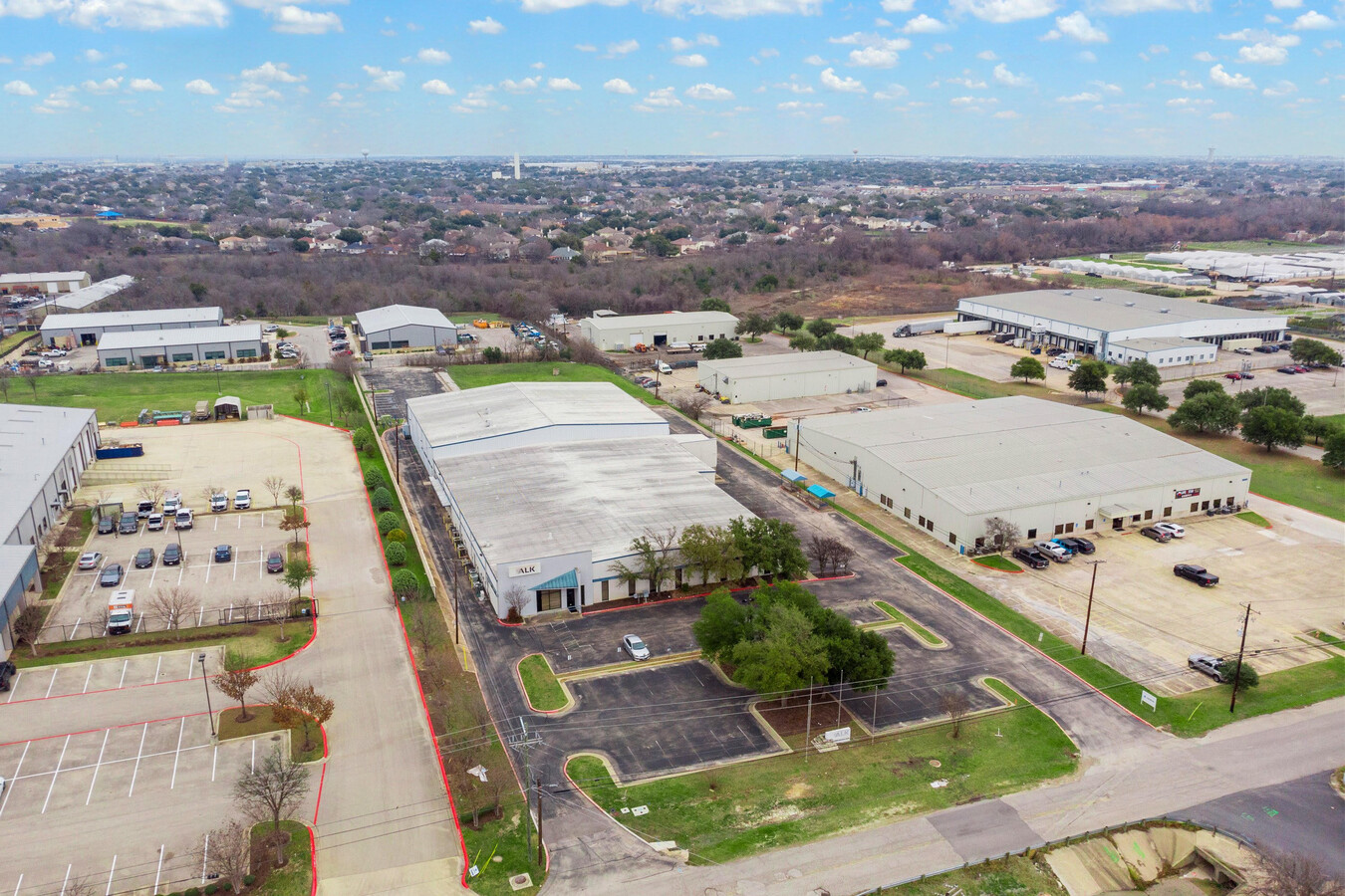
Property Record
1700 Royston Ln, Round Rock, TX 78664


Current Lease Availabilities
NEARBY LISTINGS FOR SALE OR LEASE
Property Detail
1700 Royston Ln
Austin-Round Rock, TX
Roberts George F Subd 2
279545
LOT 2 ROBERTS GEORGE F SUBD 2
Industrialgeneral
Travis
X
Texas
48491C0635F
2
2023
3.18 AC
2023
Far Northeast
046500
Austin
37,288 SF
DEMOGRAPHICS near 1700 Royston Ln
1 Mile
3 Mile
5 Mile
2024 Total Population
10,082
118,466
262,290
2029 Population
10,923
134,398
301,199
Pop Growth 2024-2029
+ 8.34%
+ 13.45%
+ 14.83%
Average Age
38
37
37
2024 Total Households
4,011
47,855
101,572
HH Growth 2024-2029
+ 8.90%
+ 14.34%
+ 15.27%
Median Household Inc
$75,709
$77,731
$83,532
Avg Household Size
2.50
2.40
2.50
2024 Avg HH Vehicles
2.00
2.00
2.00
Median Home Value
$267,950
$284,656
$316,360
Median Year Built
1998
2001
2001
Nearby Places
- Restaurants
- Banks
- Shops
- Fitness
- Groceries
PUBLIC TRANSPORTATION
AIRPORT
Austin-Bergstrom International
DRIVE
WALK
Distance
Austin-Bergstrom International
38 min
25.5 mi
Freight Ports
Calhoun Port
DRIVE
WALK
Distance
Calhoun Port
202 min
173.2 mi
Nearby Properties
Address
Land Use
TOTAL SIZE
Lot Size
Zoning
Address
Land Use
TOTAL SIZE
Lot Size
Zoning
2,089,779 SF
167.48 AC
Address
Land Use
TOTAL SIZE
Lot Size
Zoning
422,682 SF
95.18 AC
Address
Land Use
TOTAL SIZE
Lot Size
Zoning
565,886 SF
29.30 AC
Address
Land Use
TOTAL SIZE
Lot Size
Zoning
428,011 SF
25 AC
Address
Land Use
TOTAL SIZE
Lot Size
Zoning
466,256 SF
38.33 AC
Address
Land Use
TOTAL SIZE
Lot Size
Zoning
349,128 SF
18.24 AC
Address
Land Use
TOTAL SIZE
Lot Size
Zoning
470,992 SF
25.92 AC
Address
Land Use
TOTAL SIZE
Lot Size
Zoning
477,454 SF
22.28 AC
Address
Land Use
TOTAL SIZE
Lot Size
Zoning
326,015 SF
11.11 AC
Address
Land Use
TOTAL SIZE
Lot Size
Zoning
295,750 SF
21.46 AC
Address
Land Use
TOTAL SIZE
Lot Size
Zoning
283,866 SF
12.18 AC
Address
Land Use
TOTAL SIZE
Lot Size
Zoning
361,440 SF
19.35 AC
Address
Land Use
TOTAL SIZE
Lot Size
Zoning
618,605 SF
14.11 AC
PUD
Address
Land Use
TOTAL SIZE
Lot Size
Zoning
362,216 SF
19.72 AC
Address
Land Use
TOTAL SIZE
Lot Size
Zoning
344,286 SF
19.40 AC
Address
Land Use
TOTAL SIZE
Lot Size
Zoning
378,799 SF
9.03 AC
PUD
Address
Land Use
TOTAL SIZE
Lot Size
Zoning
426,415 SF
40 AC
Address
Land Use
TOTAL SIZE
Lot Size
Zoning
541,124 SF
60.16 AC
Address
Land Use
TOTAL SIZE
Lot Size
Zoning
306,387 SF
14.63 AC
Address
Land Use
TOTAL SIZE
Lot Size
Zoning
344,341 SF
19.19 AC
PUD
Address
Land Use
TOTAL SIZE
Lot Size
Zoning
543,958 SF
60.19 AC
Address
Land Use
TOTAL SIZE
Lot Size
Zoning
361,338 SF
20 AC
Address
Land Use
TOTAL SIZE
Lot Size
Zoning
379,953 SF
11.74 AC
PUD
Address
Land Use
TOTAL SIZE
Lot Size
Zoning
341,480 SF
16.35 AC
Address
Land Use
TOTAL SIZE
Lot Size
Zoning
273,462 SF
47.12 AC
Address
Land Use
TOTAL SIZE
Lot Size
Zoning
278,578 SF
14.94 AC
Address
Land Use
TOTAL SIZE
Lot Size
Zoning
216,198 SF
9.47 AC
Address
Land Use
TOTAL SIZE
Lot Size
Zoning
364,599 SF
20.41 AC
Address
Land Use
TOTAL SIZE
Lot Size
Zoning
338,958 SF
10.41 AC
PUD
Address
Land Use
TOTAL SIZE
Lot Size
Zoning
321,912 SF
15.76 AC
The World's #1 Commercial Real Estate Marketplace
Connect with us
© 2025 CoStar Group
The information above has been obtained from sources believed reliable. While we do not doubt its accuracy we have not verified it and make no guarantee, warranty or representation about it. It is your responsibility to independently confirm its accuracy and completeness. Any projections, opinions, assumptions, or estimates used are for example only and do not represent the current or future performance of the property. The value of this transaction to you depends on tax and other factors which should be evaluated by your tax, financial, and legal advisors. You and your advisors should conduct a careful, independent investigation of the property to determine to your satisfaction the suitability of the property for your needs.