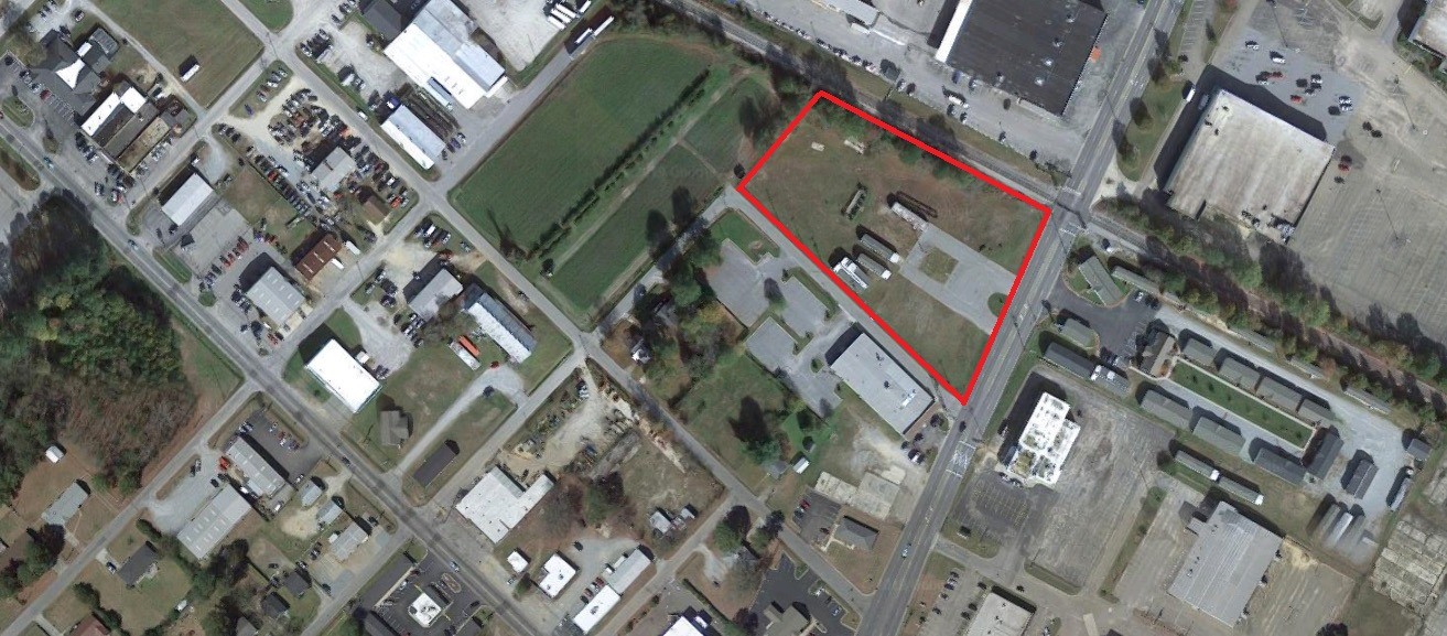
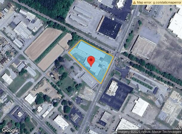
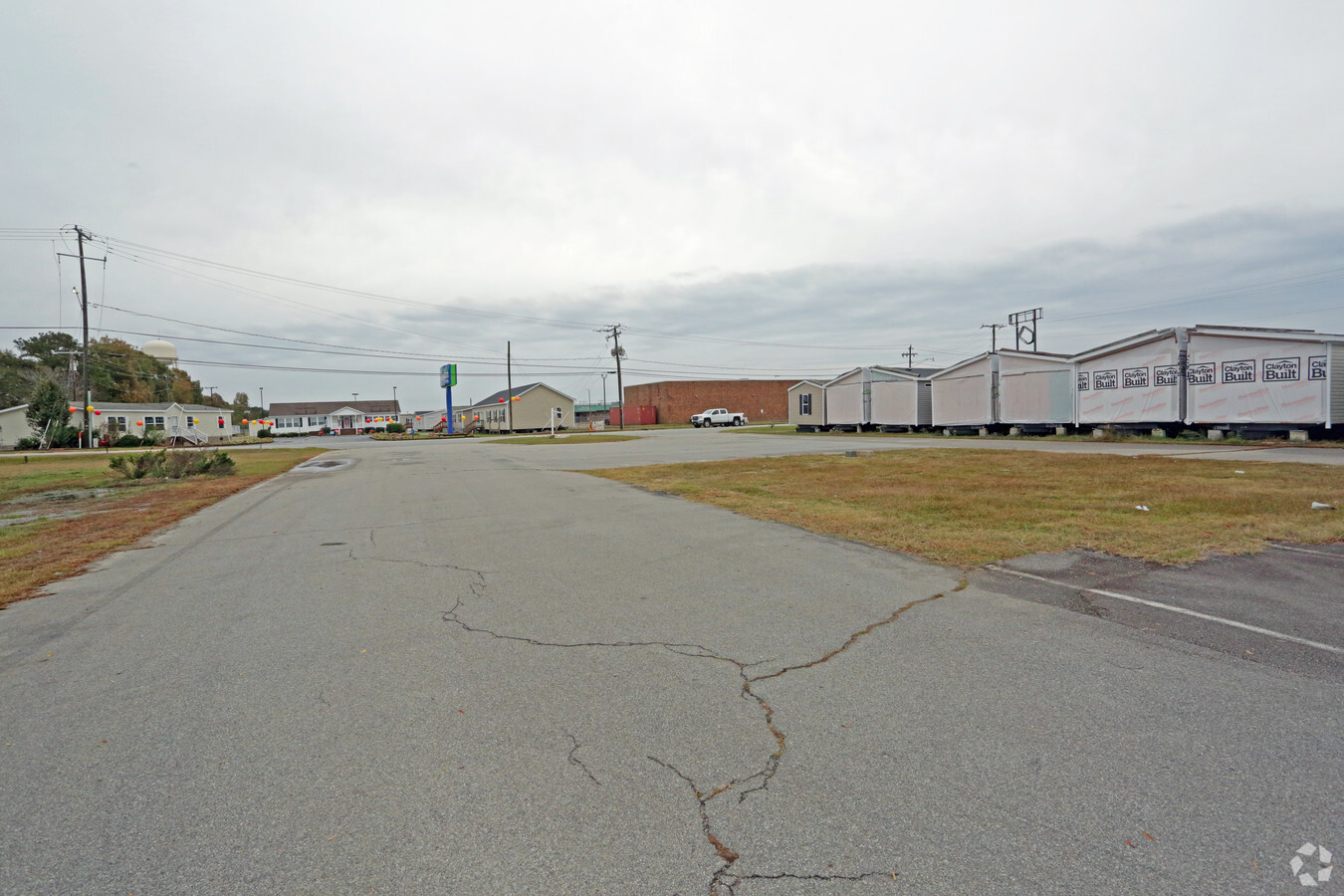
Property Record
1701 E 10Th St, Roanoke Rapids, NC 27870
NEARBY LISTINGS FOR SALE OR LEASE
Property Detail
1701 E 10Th St
09-06077
Map Showing Property Of Willis E Murprey
Commercialnec
SAL RR 10TH & NORTH ST
X
Halifax
3720399800J
North Carolina
2023
2.07 AC
2024
North Carolina Northeast Area
930400
Other Market Areas
17,620 SF
Roanoke Rapids, NC
DEMOGRAPHICS near 1701 E 10Th St
1 Mile
3 Mile
5 Mile
2024 Total Population
5,332
20,064
26,767
2029 Population
5,138
19,558
25,985
Pop Growth 2024-2029
(3.64%)
(2.52%)
(2.92%)
Average Age
43
41
42
2024 Total Households
2,489
8,540
11,483
HH Growth 2024-2029
(3.58%)
(2.51%)
(2.91%)
Median Household Inc
$36,872
$40,146
$38,730
Avg Household Size
2.10
2.30
2.30
2024 Avg HH Vehicles
2.00
2.00
2.00
Median Home Value
$132,749
$126,447
$115,464
Median Year Built
1980
1972
1976
Nearby Places
- Restaurants
- Banks
- Shops
- Fitness
- Groceries
SALE & LEASE HISTORY
LISTING DATE
SALE/LEASE

Sep 24, 2016
For Sale
Jul 15, 2019
For Sale
Nearby Properties
Address
Land Use
TOTAL SIZE
Lot Size
Zoning
Address
Land Use
TOTAL SIZE
Lot Size
Zoning
239,194 SF
48.24 AC
RRB5
Address
Land Use
TOTAL SIZE
Lot Size
Zoning
50,336 SF
113.40 AC
WELI1
Address
Land Use
TOTAL SIZE
Lot Size
Zoning
97,735 SF
21.37 AC
RRR8
Address
Land Use
TOTAL SIZE
Lot Size
Zoning
74,953 SF
107.43 AC
Address
Land Use
TOTAL SIZE
Lot Size
Zoning
94,328 SF
26.40 AC
RRR8
Address
Land Use
TOTAL SIZE
Lot Size
Zoning
203,628 SF
17.91 AC
RRB4
Address
Land Use
TOTAL SIZE
Lot Size
Zoning
11,283 SF
3.66 AC
Address
Land Use
TOTAL SIZE
Lot Size
Zoning
46,948 SF
2.31 AC
RRB4
Address
Land Use
TOTAL SIZE
Lot Size
Zoning
110,678 SF
11.34 AC
RRB4
Address
Land Use
TOTAL SIZE
Lot Size
Zoning
66,609 SF
2.60 AC
RRB4
Address
Land Use
TOTAL SIZE
Lot Size
Zoning
13,794 SF
11.34 AC
RRR
Address
Land Use
TOTAL SIZE
Lot Size
Zoning
28,316 SF
10.19 AC
RRB4
Address
Land Use
TOTAL SIZE
Lot Size
Zoning
87,165 SF
8.77 AC
RRB4
Address
Land Use
TOTAL SIZE
Lot Size
Zoning
14,000 SF
13.66 AC
RRB4
Address
Land Use
TOTAL SIZE
Lot Size
Zoning
75,392 SF
4.22 AC
RRR
Address
Land Use
TOTAL SIZE
Lot Size
Zoning
60,043 SF
1.58 AC
RRR6
Address
Land Use
TOTAL SIZE
Lot Size
Zoning
58,891 SF
2.65 AC
WELR8
Address
Land Use
TOTAL SIZE
Lot Size
Zoning
14,300 SF
10 AC
RRB4
Address
Land Use
TOTAL SIZE
Lot Size
Zoning
38,176 SF
6.20 AC
RRR6
Address
Land Use
TOTAL SIZE
Lot Size
Zoning
75,353 SF
10 AC
RRR6
Address
Land Use
TOTAL SIZE
Lot Size
Zoning
14,400 SF
4.83 AC
RRI2
Address
Land Use
TOTAL SIZE
Lot Size
Zoning
57,708 SF
2.55 AC
RRB4
Address
Land Use
TOTAL SIZE
Lot Size
Zoning
68,153 SF
20 AC
WELR8
Address
Land Use
TOTAL SIZE
Lot Size
Zoning
10,114 SF
4.45 AC
RRR6
Address
Land Use
TOTAL SIZE
Lot Size
Zoning
35,336 SF
10.21 AC
RRB4
Address
Land Use
TOTAL SIZE
Lot Size
Zoning
132,851 SF
35.37 AC
Address
Land Use
TOTAL SIZE
Lot Size
Zoning
47,641 SF
2.15 AC
RRB4
Address
Land Use
TOTAL SIZE
Lot Size
Zoning
74,222 SF
10.70 AC
RRB4
Address
Land Use
TOTAL SIZE
Lot Size
Zoning
Address
Land Use
TOTAL SIZE
Lot Size
Zoning
10,436 SF
4.92 AC
RRR6
The World's #1 Commercial Real Estate Marketplace
Connect with us
© 2025 CoStar Group
The information above has been obtained from sources believed reliable. While we do not doubt its accuracy we have not verified it and make no guarantee, warranty or representation about it. It is your responsibility to independently confirm its accuracy and completeness. Any projections, opinions, assumptions, or estimates used are for example only and do not represent the current or future performance of the property. The value of this transaction to you depends on tax and other factors which should be evaluated by your tax, financial, and legal advisors. You and your advisors should conduct a careful, independent investigation of the property to determine to your satisfaction the suitability of the property for your needs.