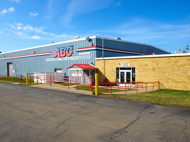
Property Record
1702 Wagner Ave, Erie, PA 16510

NEARBY LISTINGS FOR SALE OR LEASE
Property Detail
1702 Wagner Ave
Erie, PA
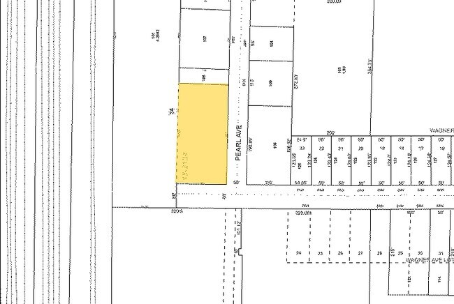
Wagner Avenue Lots Subdivision
15-021-033.0-202.00
1702 WAGNER AVE LOT A 4.55 AC NET
Warehouse
Erie
X
Pennsylvania
42049C0069D
a
2025
4.55 AC
2025
Greater Erie
001500
Erie
52,773 SF
DEMOGRAPHICS near 1702 Wagner Ave
1 Mile
3 Mile
5 Mile
2024 Total Population
11,293
67,457
118,365
2029 Population
11,166
66,671
117,091
Pop Growth 2024-2029
(1.12%)
(1.17%)
(1.08%)
Average Age
37
39
39
2024 Total Households
4,448
25,962
47,286
HH Growth 2024-2029
(1.26%)
(1.30%)
(1.18%)
Median Household Inc
$42,637
$45,297
$45,564
Avg Household Size
2.50
2.40
2.30
2024 Avg HH Vehicles
1.00
1.00
1.00
Median Home Value
$74,412
$103,651
$114,579
Median Year Built
1949
1956
1954
Nearby Places
Map Layers
Map Styles
 Street
 Aerial
- Restaurants
- Banks
- Shops
- Fitness
- Groceries
PUBLIC TRANSPORTATION
COMMUTER RAIL
Erie Amtrak Station (Lake Shore Limited - Amtrak)
DRIVE
WALK
Distance
Erie Amtrak Station (Lake Shore Limited - Amtrak)
10 min
3.8 mi
AIRPORT
Erie International/Tom Ridge Field
DRIVE
WALK
Distance
Erie International/Tom Ridge Field
21 min
9.6 mi
Freight Ports
Port of Toledo
DRIVE
WALK
Distance
Port of Toledo
262 min
219.0 mi
SALE & LEASE HISTORY
LISTING DATE
SALE/LEASE

May 22, 2018
For Sale
Nearby Properties
Address
Land Use
TOTAL SIZE
Lot Size
Zoning
Address
Land Use
TOTAL SIZE
Lot Size
Zoning
31,764 SF
46.83 AC
R3
Address
Land Use
TOTAL SIZE
Lot Size
Zoning
227,630 SF
343.90 AC
I1
Address
Land Use
TOTAL SIZE
Lot Size
Zoning
2.73 AC
C3
Address
Land Use
TOTAL SIZE
Lot Size
Zoning
12.27 AC
WM
Address
Land Use
TOTAL SIZE
Lot Size
Zoning
5 AC
RLB
Address
Land Use
TOTAL SIZE
Lot Size
Zoning
68,626 SF
86.88 AC
B1
Address
Land Use
TOTAL SIZE
Lot Size
Zoning
3,401 SF
3,161.16 AC
Address
Land Use
TOTAL SIZE
Lot Size
Zoning
92,635 SF
8.45 AC
B1
Address
Land Use
TOTAL SIZE
Lot Size
Zoning
8.60 AC
R2
Address
Land Use
TOTAL SIZE
Lot Size
Zoning
23.31 AC
C1
Address
Land Use
TOTAL SIZE
Lot Size
Zoning
18.55 AC
M1
Address
Land Use
TOTAL SIZE
Lot Size
Zoning
70,092 SF
10.78 AC
DR
Address
Land Use
TOTAL SIZE
Lot Size
Zoning
59,300 SF
16.25 AC
Address
Land Use
TOTAL SIZE
Lot Size
Zoning
2,352 SF
3 AC
WR
Address
Land Use
TOTAL SIZE
Lot Size
Zoning
9.38 AC
C1
Address
Land Use
TOTAL SIZE
Lot Size
Zoning
23.95 AC
DR
Address
Land Use
TOTAL SIZE
Lot Size
Zoning
118,270 SF
5.64 AC
R2A
Address
Land Use
TOTAL SIZE
Lot Size
Zoning
430,920 SF
1.77 AC
C3
Address
Land Use
TOTAL SIZE
Lot Size
Zoning
121,197 SF
7.58 AC
Address
Land Use
TOTAL SIZE
Lot Size
Zoning
39,572 SF
6.40 AC
RLB
Address
Land Use
TOTAL SIZE
Lot Size
Zoning
62.79 AC
R2B
Address
Land Use
TOTAL SIZE
Lot Size
Zoning
41,976 SF
6.50 AC
R2A
Address
Land Use
TOTAL SIZE
Lot Size
Zoning
158,708 SF
1.25 AC
C3
Address
Land Use
TOTAL SIZE
Lot Size
Zoning
4.76 AC
R3
Address
Land Use
TOTAL SIZE
Lot Size
Zoning
144,601 SF
2.03 AC
C3
Address
Land Use
TOTAL SIZE
Lot Size
Zoning
13,620 SF
1.21 AC
B1
Address
Land Use
TOTAL SIZE
Lot Size
Zoning
91,930 SF
10.18 AC
RLB
Address
Land Use
TOTAL SIZE
Lot Size
Zoning
5 AC
RLB
Address
Land Use
TOTAL SIZE
Lot Size
Zoning
4.94 AC
R3
Address
Land Use
TOTAL SIZE
Lot Size
Zoning
21,451 SF
13.98 AC
The World's #1 Commercial Real Estate Marketplace
Connect with us
© 2025 CoStar Group
The information above has been obtained from sources believed reliable. While we do not doubt its accuracy we have not verified it and make no guarantee, warranty or representation about it. It is your responsibility to independently confirm its accuracy and completeness. Any projections, opinions, assumptions, or estimates used are for example only and do not represent the current or future performance of the property. The value of this transaction to you depends on tax and other factors which should be evaluated by your tax, financial, and legal advisors. You and your advisors should conduct a careful, independent investigation of the property to determine to your satisfaction the suitability of the property for your needs.