Property Record
17100 Science Dr, Bowie, MD 20715
NEARBY LISTINGS FOR SALE OR LEASE
Property Detail
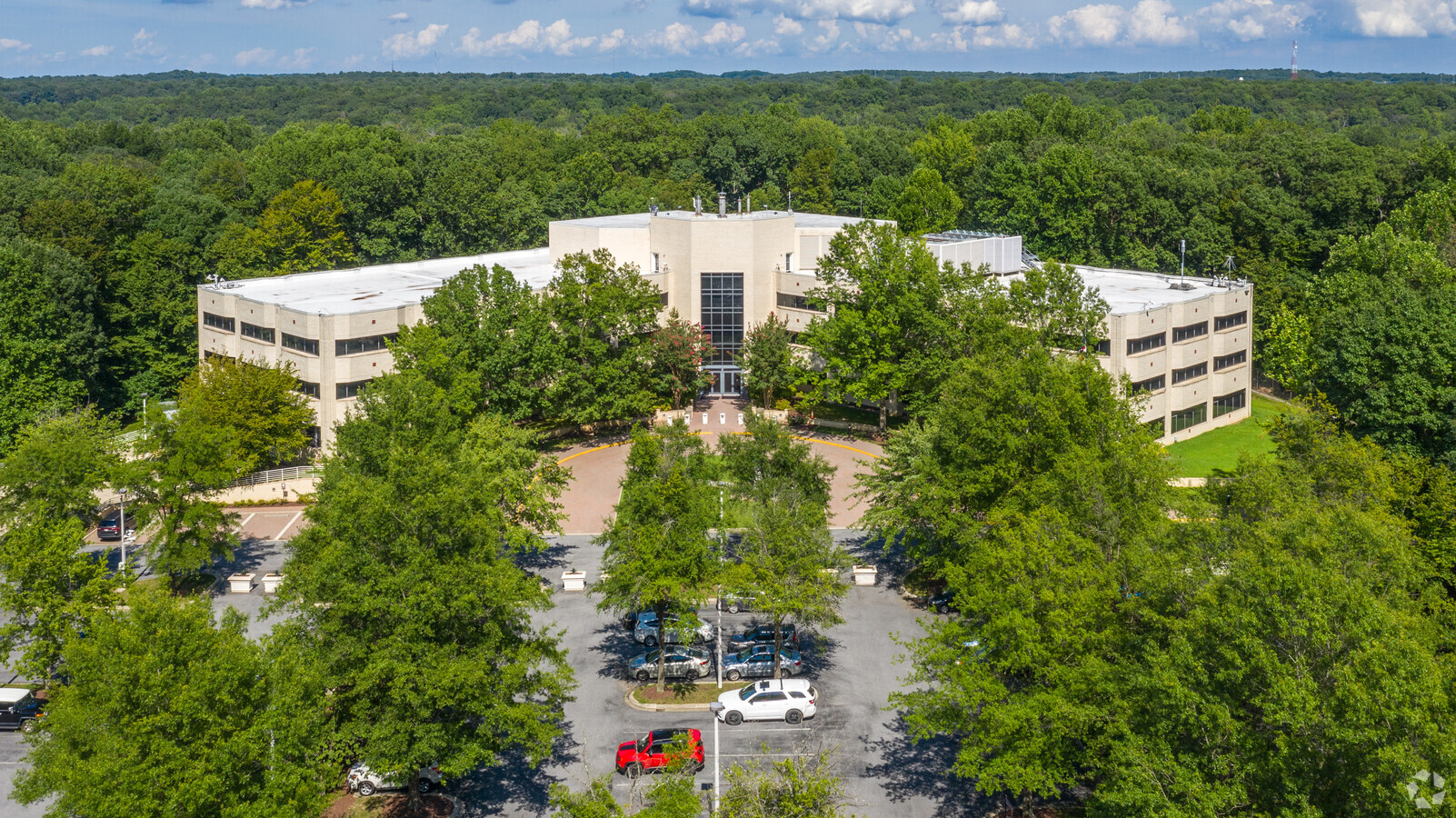
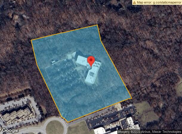
17100 Science Dr
07-0794479
PARCEL 2D
Officebuilding
Prince George's
A
Maryland
24033C0180E
14.21 AC
2024
Bowie
2024
Washington, DC
800504
Washington-Arlington-Alexandria, DC-VA-MD-WV
87,500 SF
DEMOGRAPHICS near 17100 Science Dr
1 Mile
3 Mile
5 Mile
2024 Total Population
1,443
42,404
110,618
2029 Population
1,430
41,433
109,773
Pop Growth 2024-2029
(0.90%)
(2.29%)
(0.76%)
Average Age
44
42
41
2024 Total Households
515
15,722
38,916
HH Growth 2024-2029
(1.17%)
(2.39%)
(0.69%)
Median Household Inc
$143,269
$121,361
$135,753
Avg Household Size
2.80
2.60
2.70
2024 Avg HH Vehicles
2.00
2.00
2.00
Median Home Value
$395,618
$392,435
$449,907
Median Year Built
1970
1976
1986
Nearby Places
- Restaurants
- Banks
- Shops
- Fitness
- Groceries
PUBLIC TRANSPORTATION
COMMUTER RAIL
Bowie State Marc Nb (PENN - WASHINGTON - Maryland Transit Administration)
DRIVE
WALK
Distance
Bowie State Marc Nb (PENN - WASHINGTON - Maryland Transit Administration)
16 min
6.9 mi
AIRPORT
Baltimore/Washington International Thurgood Marshall
DRIVE
WALK
Distance
Baltimore/Washington International Thurgood Marshall
34 min
21.5 mi
Ronald Reagan Washington Ntl
DRIVE
WALK
Distance
Ronald Reagan Washington Ntl
37 min
24.6 mi
Freight Ports
Port of Baltimore
DRIVE
WALK
Distance
Port of Baltimore
42 min
27.1 mi
Nearby Properties
Address
Land Use
TOTAL SIZE
Lot Size
Zoning
Address
Land Use
TOTAL SIZE
Lot Size
Zoning
278,982 SF
22.25 AC
LCD
Address
Land Use
TOTAL SIZE
Lot Size
Zoning
15.34 AC
LCD
Address
Land Use
TOTAL SIZE
Lot Size
Zoning
6.34 AC
TACE
Address
Land Use
TOTAL SIZE
Lot Size
Zoning
283,176 SF
30.51 AC
TACE
Address
Land Use
TOTAL SIZE
Lot Size
Zoning
286 SF
13.08 AC
RMF20
Address
Land Use
TOTAL SIZE
Lot Size
Zoning
338 SF
20.94 AC
TACE
Address
Land Use
TOTAL SIZE
Lot Size
Zoning
80,321 SF
11.78 AC
CGO
Address
Land Use
TOTAL SIZE
Lot Size
Zoning
287,439 SF
19.97 AC
CGO
Address
Land Use
TOTAL SIZE
Lot Size
Zoning
120,560 SF
9 AC
TACE
Address
Land Use
TOTAL SIZE
Lot Size
Zoning
159,944 SF
5.34 AC
C1
Address
Land Use
TOTAL SIZE
Lot Size
Zoning
122,290 SF
3.14 AC
TACE
Address
Land Use
TOTAL SIZE
Lot Size
Zoning
124,313 SF
12.70 AC
CGO
Address
Land Use
TOTAL SIZE
Lot Size
Zoning
170,641 SF
4.30 AC
IE
Address
Land Use
TOTAL SIZE
Lot Size
Zoning
166,720 SF
8.72 AC
TACE
Address
Land Use
TOTAL SIZE
Lot Size
Zoning
111,009 SF
11.43 AC
TACE
Address
Land Use
TOTAL SIZE
Lot Size
Zoning
140 SF
5.47 AC
TACE
Address
Land Use
TOTAL SIZE
Lot Size
Zoning
101,475 SF
5.59 AC
CGO
Address
Land Use
TOTAL SIZE
Lot Size
Zoning
8.38 AC
R22
Address
Land Use
TOTAL SIZE
Lot Size
Zoning
114,327 SF
14.44 AC
TACE
Address
Land Use
TOTAL SIZE
Lot Size
Zoning
79,939 SF
6.17 AC
LCD
Address
Land Use
TOTAL SIZE
Lot Size
Zoning
90,180 SF
6.48 AC
TACE
Address
Land Use
TOTAL SIZE
Lot Size
Zoning
124,984 SF
10.30 AC
TACE
Address
Land Use
TOTAL SIZE
Lot Size
Zoning
117,622 SF
10.93 AC
TACE
Address
Land Use
TOTAL SIZE
Lot Size
Zoning
175,036 SF
9.44 AC
TACE
Address
Land Use
TOTAL SIZE
Lot Size
Zoning
159,876 SF
13.62 AC
TACE
Address
Land Use
TOTAL SIZE
Lot Size
Zoning
65,928 SF
6.61 AC
TACE
Address
Land Use
TOTAL SIZE
Lot Size
Zoning
102,755 SF
7.61 AC
TACE
Address
Land Use
TOTAL SIZE
Lot Size
Zoning
129,800 SF
3.13 AC
LCD
Address
Land Use
TOTAL SIZE
Lot Size
Zoning
60,600 SF
6 AC
RR
Address
Land Use
TOTAL SIZE
Lot Size
Zoning
116,798 SF
12.80 AC
CGO
The World's #1 Commercial Real Estate Marketplace
Connect with us
© 2025 CoStar Group
The information above has been obtained from sources believed reliable. While we do not doubt its accuracy we have not verified it and make no guarantee, warranty or representation about it. It is your responsibility to independently confirm its accuracy and completeness. Any projections, opinions, assumptions, or estimates used are for example only and do not represent the current or future performance of the property. The value of this transaction to you depends on tax and other factors which should be evaluated by your tax, financial, and legal advisors. You and your advisors should conduct a careful, independent investigation of the property to determine to your satisfaction the suitability of the property for your needs.