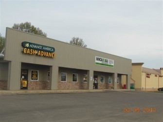
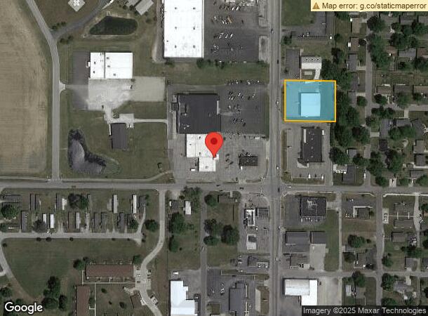
Property Record
1712 N Walnut St, Hartford City, IN 47348

NEARBY LISTINGS FOR SALE OR LEASE
Property Detail
1712 N Walnut St
Officebuilding
FR SW 2 23 10 .94 AC
X
Blackford
18009C0103C
Indiana
2023
0.94 AC
2023
Indiana North Area
975400
Other Market Areas
6,808 SF
05-03-02-303-070-000-006
DEMOGRAPHICS near 1712 N Walnut St
1 Mile
3 Mile
5 Mile
2024 Total Population
3,690
7,034
8,245
2029 Population
3,658
6,971
8,141
Pop Growth 2024-2029
(0.87%)
(0.90%)
(1.26%)
Average Age
42
42
43
2024 Total Households
1,611
3,032
3,538
HH Growth 2024-2029
(0.87%)
(0.89%)
(1.24%)
Median Household Inc
$39,048
$34,857
$39,582
Avg Household Size
2.20
2.30
2.30
2024 Avg HH Vehicles
2.00
2.00
2.00
Median Home Value
$72,480
$78,925
$86,805
Median Year Built
1957
1958
1958
Nearby Places
- Restaurants
- Banks
- Shops
- Fitness
- Groceries
Nearby Properties
Address
Land Use
TOTAL SIZE
Lot Size
Zoning
Address
Land Use
TOTAL SIZE
Lot Size
Zoning
2,880 SF
12.71 AC
ZO01
Address
Land Use
TOTAL SIZE
Lot Size
Zoning
236,260 SF
36.61 AC
ZO01
Address
Land Use
TOTAL SIZE
Lot Size
Zoning
33,720 SF
26.14 AC
ZO01
Address
Land Use
TOTAL SIZE
Lot Size
Zoning
280,295 SF
36 AC
ZO01
Address
Land Use
TOTAL SIZE
Lot Size
Zoning
22,060 SF
3.35 AC
ZO01
Address
Land Use
TOTAL SIZE
Lot Size
Zoning
25,713 SF
1.32 AC
ZO01
Address
Land Use
TOTAL SIZE
Lot Size
Zoning
154,104 SF
11.87 AC
ZO01
Address
Land Use
TOTAL SIZE
Lot Size
Zoning
26,281 SF
10 AC
ZO01
Address
Land Use
TOTAL SIZE
Lot Size
Zoning
121,443 SF
25.42 AC
ZO01
Address
Land Use
TOTAL SIZE
Lot Size
Zoning
5,920 SF
3.90 AC
ZO01
Address
Land Use
TOTAL SIZE
Lot Size
Zoning
57,750 SF
7 AC
ZO01
Address
Land Use
TOTAL SIZE
Lot Size
Zoning
24,860 SF
2.88 AC
ZO01
Address
Land Use
TOTAL SIZE
Lot Size
Zoning
118,468 SF
13.33 AC
ZO01
Address
Land Use
TOTAL SIZE
Lot Size
Zoning
13,455 SF
4.76 AC
ZO01
Address
Land Use
TOTAL SIZE
Lot Size
Zoning
53,845 SF
4.13 AC
ZO01
Address
Land Use
TOTAL SIZE
Lot Size
Zoning
10,845 SF
2.43 AC
ZO01
Address
Land Use
TOTAL SIZE
Lot Size
Zoning
20,680 SF
2.07 AC
ZO01
Address
Land Use
TOTAL SIZE
Lot Size
Zoning
1,519 SF
4.95 AC
ZO01
Address
Land Use
TOTAL SIZE
Lot Size
Zoning
3,704 SF
0.81 AC
ZO01
Address
Land Use
TOTAL SIZE
Lot Size
Zoning
51,200 SF
11.35 AC
ZO01
Address
Land Use
TOTAL SIZE
Lot Size
Zoning
86,600 SF
10 AC
ZO01
Address
Land Use
TOTAL SIZE
Lot Size
Zoning
5,032 SF
1.94 AC
ZO01
Address
Land Use
TOTAL SIZE
Lot Size
Zoning
96,573 SF
10.39 AC
ZO01
Address
Land Use
TOTAL SIZE
Lot Size
Zoning
10,662 SF
1.18 AC
ZO01
Address
Land Use
TOTAL SIZE
Lot Size
Zoning
3,000 SF
19.46 AC
ZO01
Address
Land Use
TOTAL SIZE
Lot Size
Zoning
2,184 SF
4 AC
ZO01
Address
Land Use
TOTAL SIZE
Lot Size
Zoning
104.68 AC
ZO01
Address
Land Use
TOTAL SIZE
Lot Size
Zoning
7,544 SF
1.22 AC
ZO01
Address
Land Use
TOTAL SIZE
Lot Size
Zoning
3,200 SF
24.70 AC
ZO01
Address
Land Use
TOTAL SIZE
Lot Size
Zoning
2.75 AC
ZO01
The World's #1 Commercial Real Estate Marketplace
Connect with us
© 2025 CoStar Group
The information above has been obtained from sources believed reliable. While we do not doubt its accuracy we have not verified it and make no guarantee, warranty or representation about it. It is your responsibility to independently confirm its accuracy and completeness. Any projections, opinions, assumptions, or estimates used are for example only and do not represent the current or future performance of the property. The value of this transaction to you depends on tax and other factors which should be evaluated by your tax, financial, and legal advisors. You and your advisors should conduct a careful, independent investigation of the property to determine to your satisfaction the suitability of the property for your needs.