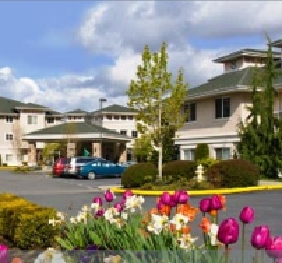
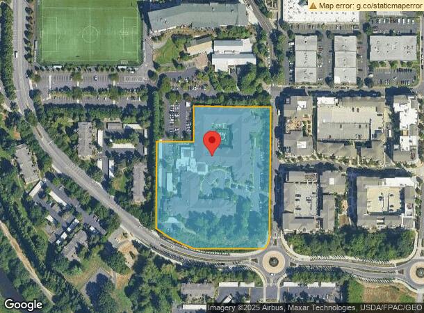
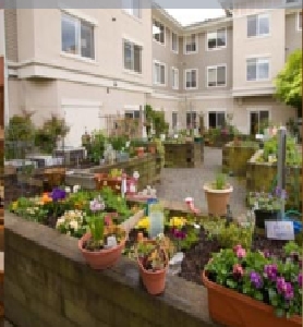
Property Record
17143 133Rd Ave Ne, Woodinville, WA 98072
NEARBY LISTINGS FOR SALE OR LEASE
Property Detail
17143 133Rd Ave Ne
Seattle-Tacoma-Bellevue, WA
Bla Bla-95-050
102605-9026
LOT A WOODINVILLE BLA #95-050 REC #9601319005 BEING POR W 435 FT OF NW 1/4 OF SW 1/4 LESS RDS & LESS FOR RDS PER RECS# 9711051491 & 20180209001051
Hospitalprivate
King
X
Washington
53033C0068H
a
2025
4.79 AC
2024
Town Center King County
032319
Seattle/Puget Sound
189,966 SF
DEMOGRAPHICS near 17143 133Rd Ave Ne
1 Mile
3 Mile
5 Mile
2024 Total Population
11,640
79,265
214,819
2029 Population
11,799
80,283
218,125
Pop Growth 2024-2029
+ 1.37%
+ 1.28%
+ 1.54%
Average Age
39
40
39
2024 Total Households
5,314
31,587
82,011
HH Growth 2024-2029
+ 1.54%
+ 1.33%
+ 1.50%
Median Household Inc
$111,579
$123,472
$137,087
Avg Household Size
2.20
2.40
2.60
2024 Avg HH Vehicles
2.00
2.00
2.00
Median Home Value
$772,662
$821,636
$850,392
Median Year Built
1991
1987
1987
Nearby Places
- Restaurants
- Banks
- Shops
- Fitness
- Groceries
PUBLIC TRANSPORTATION
AIRPORT
Seattle Paine Field International
DRIVE
WALK
Distance
Seattle Paine Field International
25 min
16.0 mi
Seattle-Tacoma International
DRIVE
WALK
Distance
Seattle-Tacoma International
40 min
28.7 mi
Freight Ports
Port of Seattle
DRIVE
WALK
Distance
Port of Seattle
35 min
24.5 mi
Nearby Properties
Address
Land Use
TOTAL SIZE
Lot Size
Zoning
Address
Land Use
TOTAL SIZE
Lot Size
Zoning
570,472 SF
17.39 AC
TL 3A
Address
Land Use
TOTAL SIZE
Lot Size
Zoning
50,400 SF
123.66 AC
C
Address
Land Use
TOTAL SIZE
Lot Size
Zoning
11.29 AC
R-AC, OP,
Address
Land Use
TOTAL SIZE
Lot Size
Zoning
2.60 AC
DN
Address
Land Use
TOTAL SIZE
Lot Size
Zoning
343,095 SF
39.09 AC
R 5,400A,
Address
Land Use
TOTAL SIZE
Lot Size
Zoning
295,920 SF
17.30 AC
R-18
Address
Land Use
TOTAL SIZE
Lot Size
Zoning
293,664 SF
38.51 AC
R 2800, OP
Address
Land Use
TOTAL SIZE
Lot Size
Zoning
190,512 SF
4.86 AC
CBD
Address
Land Use
TOTAL SIZE
Lot Size
Zoning
194,388 SF
1.65 AC
DC
Address
Land Use
TOTAL SIZE
Lot Size
Zoning
231,840 SF
22.82 AC
RMA 2.4
Address
Land Use
TOTAL SIZE
Lot Size
Zoning
226,192 SF
6.34 AC
CBD
Address
Land Use
TOTAL SIZE
Lot Size
Zoning
170,520 SF
1.92 AC
DN
Address
Land Use
TOTAL SIZE
Lot Size
Zoning
43,016 SF
10.33 AC
TL 2
Address
Land Use
TOTAL SIZE
Lot Size
Zoning
75,661 SF
30.54 AC
R 8400
Address
Land Use
TOTAL SIZE
Lot Size
Zoning
187,590 SF
17.20 AC
R 2800, OP
Address
Land Use
TOTAL SIZE
Lot Size
Zoning
220,523 SF
11.63 AC
BP
Address
Land Use
TOTAL SIZE
Lot Size
Zoning
185,400 SF
8.05 AC
RM 1.8
Address
Land Use
TOTAL SIZE
Lot Size
Zoning
158,220 SF
13.28 AC
RMA 2.4
Address
Land Use
TOTAL SIZE
Lot Size
Zoning
77,520 SF
4.14 AC
TL 3B
Address
Land Use
TOTAL SIZE
Lot Size
Zoning
122,766 SF
2 AC
GDC
Address
Land Use
TOTAL SIZE
Lot Size
Zoning
130,800 SF
2.28 AC
CBD
Address
Land Use
TOTAL SIZE
Lot Size
Zoning
182,875 SF
16.47 AC
R-AC, OP,
Address
Land Use
TOTAL SIZE
Lot Size
Zoning
204,428 SF
34.65 AC
R 9600
Address
Land Use
TOTAL SIZE
Lot Size
Zoning
119,470 SF
1.56 AC
DN
Address
Land Use
TOTAL SIZE
Lot Size
Zoning
126,522 SF
2.62 AC
CBD
Address
Land Use
TOTAL SIZE
Lot Size
Zoning
114,513 SF
2.35 AC
GDC
Address
Land Use
TOTAL SIZE
Lot Size
Zoning
113,880 SF
1.56 AC
GDC
Address
Land Use
TOTAL SIZE
Lot Size
Zoning
229,632 SF
37.61 AC
P/I
Address
Land Use
TOTAL SIZE
Lot Size
Zoning
194,954 SF
49.73 AC
PUBLIC/SEM
The World's #1 Commercial Real Estate Marketplace
Connect with us
© 2025 CoStar Group
The information above has been obtained from sources believed reliable. While we do not doubt its accuracy we have not verified it and make no guarantee, warranty or representation about it. It is your responsibility to independently confirm its accuracy and completeness. Any projections, opinions, assumptions, or estimates used are for example only and do not represent the current or future performance of the property. The value of this transaction to you depends on tax and other factors which should be evaluated by your tax, financial, and legal advisors. You and your advisors should conduct a careful, independent investigation of the property to determine to your satisfaction the suitability of the property for your needs.