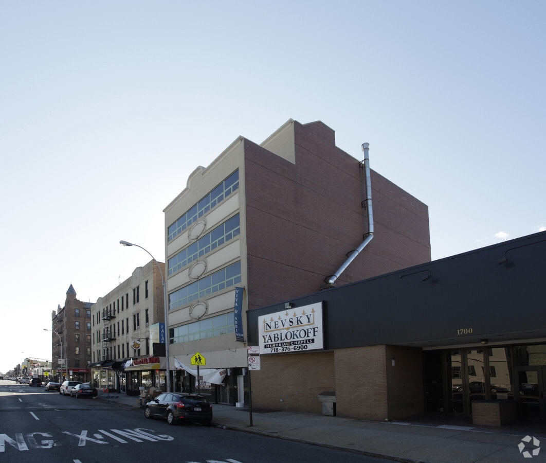
Property Record
1716 Coney Island Ave, Brooklyn, NY 11230
Current Lease Availabilities
NEARBY LISTINGS FOR SALE OR LEASE
Property Detail
1716 Coney Island Ave
06573-0040
DOCID-2016120701375002
Officebuilding
Kings
X
New York
3604970352F
40
2024
0.09 AC
2024
South Brooklyn
045400
Long Island (New York)
25,600 SF
New York-Jersey City-White Plains, NY-NJ
DEMOGRAPHICS near 1716 Coney Island Ave
1 Mile
3 Mile
5 Mile
2024 Total Population
137,617
1,023,799
1,816,818
2029 Population
130,781
951,766
1,693,824
Pop Growth 2024-2029
(4.97%)
(7.04%)
(6.77%)
Average Age
39
40
40
2024 Total Households
46,924
350,667
658,242
HH Growth 2024-2029
(5.36%)
(7.34%)
(7.07%)
Median Household Inc
$64,538
$64,940
$67,124
Avg Household Size
2.80
2.80
2.60
2024 Avg HH Vehicles
1.00
1.00
1.00
Median Home Value
$905,339
$782,102
$814,984
Median Year Built
1947
1948
1948
Nearby Places
- Restaurants
- Banks
- Shops
- Fitness
- Groceries
PUBLIC TRANSPORTATION
TRANSIT/SUBWAY
Avenue M (Q - New York MTA Subway (The Subway))
DRIVE
WALK
Distance
Avenue M (Q - New York MTA Subway (The Subway))
1 min
6 min
0.3 mi
Avenue N (F - New York MTA Subway (The Subway))
DRIVE
WALK
Distance
Avenue N (F - New York MTA Subway (The Subway))
2 min
13 min
0.7 mi
Kings Highway (B,Q Line) (B - New York MTA Subway (The Subway), Q - New York MTA Subway (The Subway))
DRIVE
WALK
Distance
Kings Highway (B,Q Line) (B - New York MTA Subway (The Subway), Q - New York MTA Subway (The Subway))
1 min
14 min
0.7 mi
Avenue J (Q - New York MTA Subway (The Subway))
DRIVE
WALK
Distance
Avenue J (Q - New York MTA Subway (The Subway))
2 min
15 min
0.8 mi
Avenue P (F - New York MTA Subway (The Subway))
DRIVE
WALK
Distance
Avenue P (F - New York MTA Subway (The Subway))
2 min
17 min
0.9 mi
COMMUTER RAIL
Nostrand Avenue Station (Far Rockaway Branch - Long Island Rail Road, Hempstead Branch - Long Island Rail Road, Long Beach Branch - Long Island Rail Road, West Hempstead Branch - Long Island Rail Road)
DRIVE
WALK
Distance
Nostrand Avenue Station (Far Rockaway Branch - Long Island Rail Road, Hempstead Branch - Long Island Rail Road, Long Beach Branch - Long Island Rail Road, West Hempstead Branch - Long Island Rail Road)
13 min
5.4 mi
Atlantic Terminal (Babylon Branch - Long Island Rail Road, City Terminal Zone - Long Island Rail Road, Hempstead Branch - Long Island Rail Road, West Hempstead Branch - Long Island Rail Road)
DRIVE
WALK
Distance
Atlantic Terminal (Babylon Branch - Long Island Rail Road, City Terminal Zone - Long Island Rail Road, Hempstead Branch - Long Island Rail Road, West Hempstead Branch - Long Island Rail Road)
12 min
5.5 mi
AIRPORT
John F Kennedy International
DRIVE
WALK
Distance
John F Kennedy International
23 min
13.6 mi
Laguardia
DRIVE
WALK
Distance
Laguardia
29 min
14.5 mi
Newark Liberty International
DRIVE
WALK
Distance
Newark Liberty International
34 min
20.4 mi
Freight Ports
NY - Red Hook Container Terminal
DRIVE
WALK
Distance
NY - Red Hook Container Terminal
10 min
5.8 mi
Nearby Properties
Address
Land Use
TOTAL SIZE
Lot Size
Zoning
Address
Land Use
TOTAL SIZE
Lot Size
Zoning
2,401,524 SF
20.78 AC
M3-1
Address
Land Use
TOTAL SIZE
Lot Size
Zoning
1,503,150 SF
20.47 AC
R5
Address
Land Use
TOTAL SIZE
Lot Size
Zoning
1,066,042 SF
10.45 AC
R4
Address
Land Use
TOTAL SIZE
Lot Size
Zoning
10,250 SF
773.50 AC
PARK
Address
Land Use
TOTAL SIZE
Lot Size
Zoning
965,600 SF
6.65 AC
R5
Address
Land Use
TOTAL SIZE
Lot Size
Zoning
1,061,228 SF
8.86 AC
R5
Address
Land Use
TOTAL SIZE
Lot Size
Zoning
1,073,920 SF
16.53 AC
R6
Address
Land Use
TOTAL SIZE
Lot Size
Zoning
335,800 SF
1.51 AC
R6
Address
Land Use
TOTAL SIZE
Lot Size
Zoning
54.78 AC
PARK
Address
Land Use
TOTAL SIZE
Lot Size
Zoning
785,450 SF
14.22 AC
R6
Address
Land Use
TOTAL SIZE
Lot Size
Zoning
61.60 AC
PARK
Address
Land Use
TOTAL SIZE
Lot Size
Zoning
371,139 SF
3.22 AC
R5
Address
Land Use
TOTAL SIZE
Lot Size
Zoning
226,429 SF
1.52 AC
R5B
Address
Land Use
TOTAL SIZE
Lot Size
Zoning
241,735 SF
1.99 AC
C8-4
Address
Land Use
TOTAL SIZE
Lot Size
Zoning
259,823 SF
11.47 AC
M1-1
Address
Land Use
TOTAL SIZE
Lot Size
Zoning
7,948 SF
65.50 AC
R4
Address
Land Use
TOTAL SIZE
Lot Size
Zoning
366,757 SF
0.74 AC
R7-1
Address
Land Use
TOTAL SIZE
Lot Size
Zoning
59,063 SF
21.56 AC
PARK
Address
Land Use
TOTAL SIZE
Lot Size
Zoning
247,400 SF
4.34 AC
C44A
Address
Land Use
TOTAL SIZE
Lot Size
Zoning
846,056 SF
20.71 AC
R5
Address
Land Use
TOTAL SIZE
Lot Size
Zoning
137,500 SF
2.13 AC
M1-1
Address
Land Use
TOTAL SIZE
Lot Size
Zoning
276,288 SF
0.73 AC
R8A
Address
Land Use
TOTAL SIZE
Lot Size
Zoning
356,000 SF
8.19 AC
R5
Address
Land Use
TOTAL SIZE
Lot Size
Zoning
387,706 SF
8 AC
C4-2
Address
Land Use
TOTAL SIZE
Lot Size
Zoning
393,092 SF
1.07 AC
R8A
Address
Land Use
TOTAL SIZE
Lot Size
Zoning
382,162 SF
1.65 AC
R7A
Address
Land Use
TOTAL SIZE
Lot Size
Zoning
221,704 SF
0.82 AC
R5B
Address
Land Use
TOTAL SIZE
Lot Size
Zoning
128,170 SF
0.87 AC
R7A
Address
Land Use
TOTAL SIZE
Lot Size
Zoning
822,192 SF
14.15 AC
R6
Address
Land Use
TOTAL SIZE
Lot Size
Zoning
470,000 SF
3.39 AC
R6
The World's #1 Commercial Real Estate Marketplace
Connect with us
© 2025 CoStar Group
The information above has been obtained from sources believed reliable. While we do not doubt its accuracy we have not verified it and make no guarantee, warranty or representation about it. It is your responsibility to independently confirm its accuracy and completeness. Any projections, opinions, assumptions, or estimates used are for example only and do not represent the current or future performance of the property. The value of this transaction to you depends on tax and other factors which should be evaluated by your tax, financial, and legal advisors. You and your advisors should conduct a careful, independent investigation of the property to determine to your satisfaction the suitability of the property for your needs.