Property Record
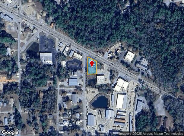
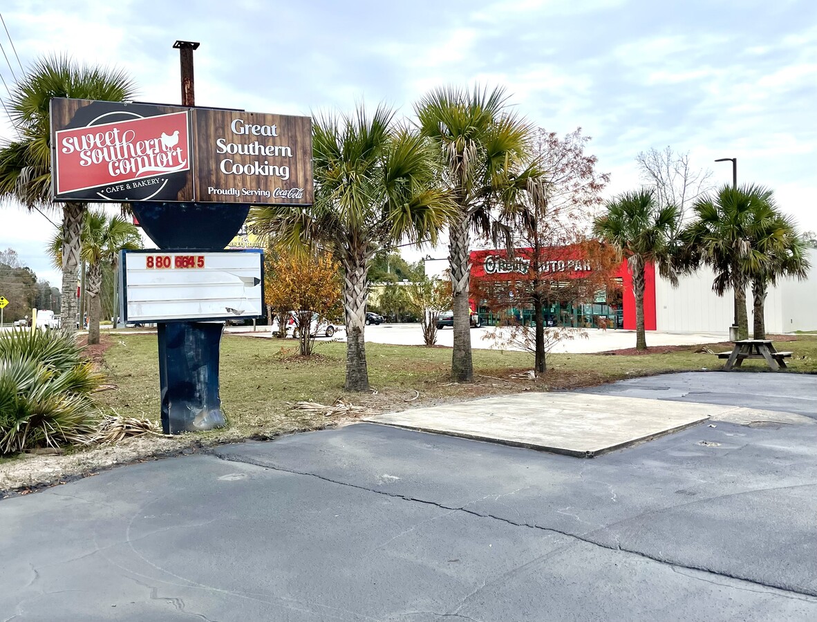
172 State Highway 20 E, Freeport, FL 32439

NEARBY LISTINGS FOR SALE OR LEASE
-
-
-
No Photo
-
View all Freeport listings for sale on LoopNet.com
Property Detail
172 State Highway 20 E
Crestview-Fort Walton Beach-Destin, FL
Town Of Freeport
15-1S-19-23040-010-003A
COM AT SW/C OF BLK 10 TOWN OF FREEPORT PB O-J, RUN N ALONG W SIDE OF SAID BLK 160FT TO POB, CONT N TO SLY R/W LINE OF SR 20, SELY ALONG R/W 110FT S 140FT, W 100FT TO POB OR 3327-2992
Restaurantbuilding
Walton
X
Florida
12131C0557H
3a
2023
0.36 AC
2024
Florida Panhandle Area
950502
Other Market Areas
3,456 SF
DEMOGRAPHICS near 172 State Highway 20 E
1 Mile
3 Mile
5 Mile
2024 Total Population
1,449
6,945
10,090
2029 Population
1,816
8,669
12,517
Pop Growth 2024-2029
+ 25.33%
+ 24.82%
+ 24.05%
Average Age
36
38
38
2024 Total Households
526
2,532
3,721
HH Growth 2024-2029
+ 25.67%
+ 25.24%
+ 24.35%
Median Household Inc
$53,500
$50,472
$49,568
Avg Household Size
2.70
2.70
2.60
2024 Avg HH Vehicles
2.00
2.00
2.00
Median Home Value
$269,078
$295,531
$283,494
Median Year Built
2008
2010
2007
Nearby Places
- Restaurants
- Banks
- Shops
- Fitness
- Groceries
PUBLIC TRANSPORTATION
AIRPORT
Eglin AFB/Destin-Ft Walton Beach
DRIVE
WALK
Distance
Eglin AFB/Destin-Ft Walton Beach
60 min
29.0 mi
Northwest Florida Beaches International
DRIVE
WALK
Distance
Northwest Florida Beaches International
43 min
31.4 mi
Freight Ports
Port of Panama City
DRIVE
WALK
Distance
Port of Panama City
60 min
42.0 mi
SALE & LEASE HISTORY
LISTING DATE
SALE/LEASE

Jan 03, 2024
For Sale
Nearby Properties
Address
Land Use
TOTAL SIZE
Lot Size
Zoning
Address
Land Use
TOTAL SIZE
Lot Size
Zoning
325,924 SF
13.94 AC
MUNI
Address
Land Use
TOTAL SIZE
Lot Size
Zoning
63,166 SF
9.06 AC
3310
Address
Land Use
TOTAL SIZE
Lot Size
Zoning
161,667 SF
26.97 AC
3310
Address
Land Use
TOTAL SIZE
Lot Size
Zoning
14,365 SF
100.36 AC
BYLAGR
Address
Land Use
TOTAL SIZE
Lot Size
Zoning
88.24 AC
3310
Address
Land Use
TOTAL SIZE
Lot Size
Zoning
31,217 SF
5.45 AC
3310
Address
Land Use
TOTAL SIZE
Lot Size
Zoning
20,275 SF
12.68 AC
MUNI
Address
Land Use
TOTAL SIZE
Lot Size
Zoning
12,472 SF
10.63 AC
Address
Land Use
TOTAL SIZE
Lot Size
Zoning
4,400 SF
6.04 AC
3310
Address
Land Use
TOTAL SIZE
Lot Size
Zoning
16,804 SF
2.07 AC
Address
Land Use
TOTAL SIZE
Lot Size
Zoning
10.84 AC
MUNI
Address
Land Use
TOTAL SIZE
Lot Size
Zoning
87,549 SF
11 AC
Address
Land Use
TOTAL SIZE
Lot Size
Zoning
30,164 SF
2.23 AC
3310
Address
Land Use
TOTAL SIZE
Lot Size
Zoning
306.09 AC
3310
Address
Land Use
TOTAL SIZE
Lot Size
Zoning
12,080 SF
3.12 AC
Address
Land Use
TOTAL SIZE
Lot Size
Zoning
17,730 SF
2.68 AC
Address
Land Use
TOTAL SIZE
Lot Size
Zoning
5,040 SF
36.94 AC
Address
Land Use
TOTAL SIZE
Lot Size
Zoning
9,475 SF
8.45 AC
3310
Address
Land Use
TOTAL SIZE
Lot Size
Zoning
38,148 SF
4.04 AC
3310
Address
Land Use
TOTAL SIZE
Lot Size
Zoning
25,532 SF
4.24 AC
Address
Land Use
TOTAL SIZE
Lot Size
Zoning
333.09 AC
3310
Address
Land Use
TOTAL SIZE
Lot Size
Zoning
59,516 SF
4.84 AC
MUNI
Address
Land Use
TOTAL SIZE
Lot Size
Zoning
16,297 SF
13.93 AC
Address
Land Use
TOTAL SIZE
Lot Size
Zoning
1,240 SF
99.84 AC
BYLAGR
Address
Land Use
TOTAL SIZE
Lot Size
Zoning
9,750 SF
7.60 AC
BAYN
Address
Land Use
TOTAL SIZE
Lot Size
Zoning
23,975 SF
1 AC
3310
Address
Land Use
TOTAL SIZE
Lot Size
Zoning
8.65 AC
3310
Address
Land Use
TOTAL SIZE
Lot Size
Zoning
15,076 SF
6 AC
Address
Land Use
TOTAL SIZE
Lot Size
Zoning
4,535 SF
1.09 AC
3310
The World's #1 Commercial Real Estate Marketplace
Connect with us
© 2025 CoStar Group
The information above has been obtained from sources believed reliable. While we do not doubt its accuracy we have not verified it and make no guarantee, warranty or representation about it. It is your responsibility to independently confirm its accuracy and completeness. Any projections, opinions, assumptions, or estimates used are for example only and do not represent the current or future performance of the property. The value of this transaction to you depends on tax and other factors which should be evaluated by your tax, financial, and legal advisors. You and your advisors should conduct a careful, independent investigation of the property to determine to your satisfaction the suitability of the property for your needs.