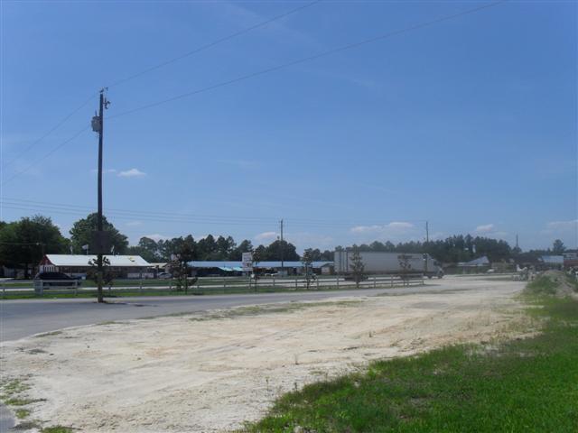
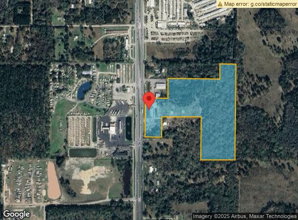
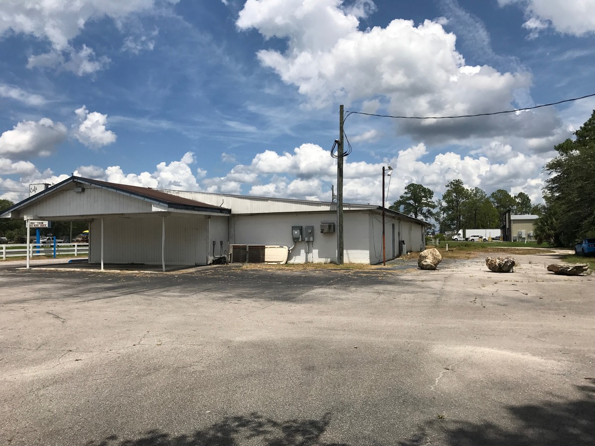
Property Record
17313 Ne Us Highway 301, Waldo, FL 32694

NEARBY LISTINGS FOR SALE OR LEASE
-
-
View all Waldo listings for sale on LoopNet.com
Property Detail
17313 Ne Us Highway 301
Gainesville, FL
Capstone Quarters
16970-000-000
Alachua
Sfr
Florida
A
25.02 AC
12007C0260E
Gainesville
1,649 SF
Other Market Areas
DEMOGRAPHICS near 17313 Ne Us Highway 301
1 Mile
3 Mile
5 Mile
2024 Total Population
103
1,575
3,774
2029 Population
106
1,646
3,940
Pop Growth 2024-2029
+ 2.91%
+ 4.51%
+ 4.40%
Average Age
42
43
43
2024 Total Households
46
654
1,541
HH Growth 2024-2029
+ 4.35%
+ 4.13%
+ 3.83%
Median Household Inc
$23,586
$37,500
$44,110
Avg Household Size
2.10
2.40
2.40
2024 Avg HH Vehicles
2.00
2.00
2.00
Median Home Value
$145,454
$144,973
$142,592
Median Year Built
1950
1980
1983
Nearby Places
- Restaurants
- Banks
- Shops
- Fitness
- Groceries
PUBLIC TRANSPORTATION
AIRPORT
Gainesville Regional
DRIVE
WALK
Distance
Gainesville Regional
22 min
13.8 mi
Freight Ports
Jacksonville Port
DRIVE
WALK
Distance
Jacksonville Port
75 min
59.2 mi
SALE & LEASE HISTORY
LISTING DATE
SALE/LEASE

Oct 03, 2017
For Sale
Nearby Properties
Address
Land Use
TOTAL SIZE
Lot Size
Zoning
Address
Land Use
TOTAL SIZE
Lot Size
Zoning
1,288 SF
18.43 AC
W301
Address
Land Use
TOTAL SIZE
Lot Size
Zoning
24,076 SF
2 AC
W301
Address
Land Use
TOTAL SIZE
Lot Size
Zoning
38,426 SF
7.16 AC
CC
Address
Land Use
TOTAL SIZE
Lot Size
Zoning
30,134 SF
3.41 AC
RESMED
Address
Land Use
TOTAL SIZE
Lot Size
Zoning
19,220 SF
2.84 AC
RESMED
Address
Land Use
TOTAL SIZE
Lot Size
Zoning
9,645 SF
4 AC
W301
Address
Land Use
TOTAL SIZE
Lot Size
Zoning
21,792 SF
39.70 AC
W301
Address
Land Use
TOTAL SIZE
Lot Size
Zoning
18,000 SF
0.89 AC
RESMED
Address
Land Use
TOTAL SIZE
Lot Size
Zoning
882 SF
79.62 AC
W301
Address
Land Use
TOTAL SIZE
Lot Size
Zoning
191 SF
7 AC
W301
Address
Land Use
TOTAL SIZE
Lot Size
Zoning
3,247 SF
2.01 AC
LIND
Address
Land Use
TOTAL SIZE
Lot Size
Zoning
3,339 SF
2.71 AC
COMM
Address
Land Use
TOTAL SIZE
Lot Size
Zoning
8,500 SF
1.94 AC
CC
Address
Land Use
TOTAL SIZE
Lot Size
Zoning
7,944 SF
199.93 AC
Address
Land Use
TOTAL SIZE
Lot Size
Zoning
7,865 SF
0.81 AC
RESMED
Address
Land Use
TOTAL SIZE
Lot Size
Zoning
13,640 SF
1.84 AC
W301
Address
Land Use
TOTAL SIZE
Lot Size
Zoning
9,012 SF
1.09 AC
C0MM
Address
Land Use
TOTAL SIZE
Lot Size
Zoning
7,000 SF
0.80 AC
COMM
Address
Land Use
TOTAL SIZE
Lot Size
Zoning
5,584 SF
1.05 AC
BH
Address
Land Use
TOTAL SIZE
Lot Size
Zoning
4.86 AC
Address
Land Use
TOTAL SIZE
Lot Size
Zoning
8,072 SF
1.09 AC
RESMED
Address
Land Use
TOTAL SIZE
Lot Size
Zoning
1,923 SF
4.04 AC
REC
Address
Land Use
TOTAL SIZE
Lot Size
Zoning
1,827 SF
110.26 AC
A
Address
Land Use
TOTAL SIZE
Lot Size
Zoning
3,908 SF
10.25 AC
Address
Land Use
TOTAL SIZE
Lot Size
Zoning
1,699 SF
1.28 AC
W301
Address
Land Use
TOTAL SIZE
Lot Size
Zoning
88.39 AC
A
Address
Land Use
TOTAL SIZE
Lot Size
Zoning
292.82 AC
A
Address
Land Use
TOTAL SIZE
Lot Size
Zoning
5,718 SF
10.79 AC
Address
Land Use
TOTAL SIZE
Lot Size
Zoning
1,440 SF
0.92 AC
C0MM
The World's #1 Commercial Real Estate Marketplace
Connect with us
© 2025 CoStar Group
The information above has been obtained from sources believed reliable. While we do not doubt its accuracy we have not verified it and make no guarantee, warranty or representation about it. It is your responsibility to independently confirm its accuracy and completeness. Any projections, opinions, assumptions, or estimates used are for example only and do not represent the current or future performance of the property. The value of this transaction to you depends on tax and other factors which should be evaluated by your tax, financial, and legal advisors. You and your advisors should conduct a careful, independent investigation of the property to determine to your satisfaction the suitability of the property for your needs.